
June 1st marks the official start of the 2023 Atlantic Hurricane Season which will continue through November. On May 25th, the National Oceanic and Atmospheric Administration (NOAA) published their outlook for the 2023 Atlantic hurricane season. NOAA predicts that the 2023 Atlantic basin hurricane season will be near-normal due in part to El Niño, and above-average Atlantic temperatures.
Forecasters at NOAA’s Climate Prediction Center, a division of the National Weather Service, are predicting near-normal hurricane activity in the Atlantic this year. NOAA’s outlook for the 2023 Atlantic hurricane season, which goes from June 1 to November 30, predicts a 40% chance of a near-normal season, a 30% chance of an above-normal season and a 30% chance of a below-normal season.
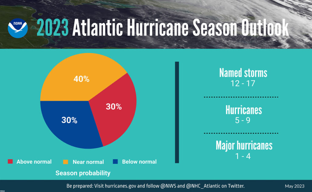
For the 2022 hurricane season, NOAA is forecasting a likely range of 12 to 17 named storms (winds of 39 mph or higher), of which 5 to 9 could become hurricanes (winds of 74 mph or higher), including 1 to 4 major hurricanes (category 3, 4 or 5; with winds of 111 mph or higher). NOAA provides these ranges with a 70% confidence.
“Thanks to the Commerce Department and NOAA’s critical investments this year in scientific and technological advancements in hurricane modeling, NOAA will be able to deliver even more accurate forecasts, helping ensure communities have the information they need to prepare for and respond to the destructive economic and ecological impacts of Atlantic hurricanes.”
Secretary of Commerce Gina M. Raimondo
The upcoming Atlantic hurricane season is expected to be less active than recent years, due to competing factors — some that suppress storm development and some that fuel it — driving this year’s overall forecast for a near-normal season.
After three hurricane seasons with La Nina present, NOAA scientists predict a high potential for El Niño to develop this summer, which can suppress Atlantic hurricane activity. El Niño’s potential influence on storm development could be offset by favorable conditions local to the tropical Atlantic Basin. Those conditions include the potential for an above-normal west African monsoon, which produces African easterly waves and seeds some of the stronger and longer-lived Atlantic storms, and warmer-than-normal sea surface temperatures in the tropical Atlantic Ocean and Caribbean Sea which creates more energy to fuel storm development. These factors are part of the longer term variability in Atlantic atmospheric and oceanic conditions that are conducive to hurricane development — known as the high-activity era for Atlantic hurricanes — which have been producing more active Atlantic hurricane seasons since 1995.
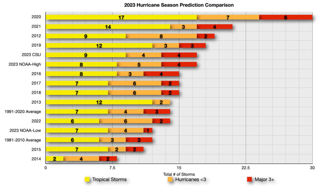
Colorado State University’s (CSU) Department of Atmospheric Sciences which published their report in April, is similar to NOAA’s outlook as they to anticipate the 2023 Atlantic basin hurricane season will be slightly below-average activity. The report for 2023 estimates about 6 hurricanes, 13 named storms, and 2 major hurricanes.
CSU anticipates that the 2023 Atlantic basin hurricane season will have slightly below-normal activity. According to the CSU forecast, current neutral ENSO conditions look fairly likely to transition to El Niño this summer/fall. However, there is considerable uncertainty as to how strong an El Niño would be, if it does develop. Sea surface temperatures in the eastern and central Atlantic are much warmer than normal, so if a robust El Niño does not develop, the potential still exists for a busy Atlantic hurricane season. Larger-than-normal uncertainty exists with this outlook. CSU forecasters anticipate a near-average probability for major hurricanes making landfall along the continental United States coastline and in the Caribbean. As is the case with all hurricane seasons, coastal residents are reminded that it only takes one hurricane making landfall to make it an active season for them. They should prepare the same for every season, regardless of how much activity is predicted
Below is a comparison of the NOAA and Colorado State University’s predictions along with the 1981-2010 long term average, 1991-2020 long term average, and final numbers for 2012-2022. As you can see, the 2023 NOAA high comes in well below the record setting 2020 season which had 30 named storms develop in the Atlantic Basin. CSU predictions are above the new long term average. NOAA’s low end predictions for total storms match the old long term average.
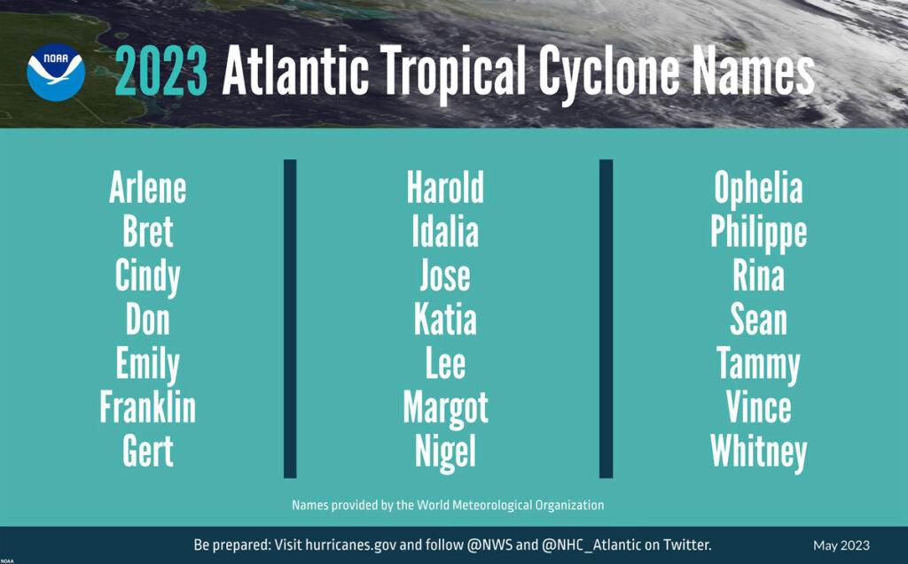
2023 Atlantic Basin Tropical Cyclone Names
NHC’s tropical cyclone advisory archive for the following potential named storms can be viewed here.
- Arlene
- Bret
- Cindy
- Don
- Emily
- Franklin
- Gert
- Harold
- Idalia
- Jose
- Katia
- Lee
- Margot
- Nigel
- Ophelia
- Philippe
- Rina
- Sean
- Tammy
- Vince
- Whitney
- Followed by the greek alphabet, if needed.
New for this year, NOAA will implement a series of upgraded and improvements to products and services that will improve hurricane forecasting during the 2023 season.
- The National Hurricane Center’s Tropical Weather Outlook graphic, which shows tropical cyclone formation potential, has expanded the forecast range from five to seven days.
- Over the last 10 years, flooding from tropical storm rainfall was the single deadliest hazard. To give communities more time to prepare, the Weather Prediction Center is extending the Excessive Rainfall Outlook an additional two days, now providing forecasts up to five days in advance. The outlook shows general areas at risk for flash flooding due to excessive rainfall.
- The National Weather Service will unveil a new generation of forecast flood inundation mapping for portions of Texas and portions of the Mid-Atlantic and Northeast in September 2023. These forecast maps will extend to the rest of the U.S. by 2026. Forecast flood inundation maps will show the extent of flooding at the street level.
NOAA will expand the capacity of its operational supercomputing system by 20%. This increase in computing capability will enable NOAA to improve and run more complex forecast models, including significant model upgrades this hurricane season:
- In late June, the Hurricane Analysis and Forecast System (HAFS) will become operational. HAFS will run this season in tandem with the currently operational Hurricane Weather Research and Forecast Model System and Hurricanes in a Multi-scale Ocean-coupled Non-hydrostatic model, but eventually will become NOAA’s primary hurricane model. Retrospective analysis of tropical storms and hurricanes from the 2020-2022 seasons show that this model has a 10-15% improvement in track forecasts over existing operational models. This new model was jointly created by NOAA’s Atlantic Oceanographic & Meteorological Laboratory Hurricane Modeling and Prediction Program and NOAA’s National Weather Service Environmental Modeling Center.
- The Probabilistic Storm Surge model upgrade on May 2, advances storm surge forecasting for the contiguous U.S. and new forecasts for surge, tide and waves for Puerto Rico and the U.S. Virgin Islands. Forecasters now have the ability to run the model for two storms simultaneously. This model provides forecasters with the likelihood, or probability, of various flooding scenarios including a near worst-case scenario to help communities prepare for all potential outcomes.
It is important to keep in mind that these annual forecasts are just predictions, not what will happen. Mother Nature can, and will do whatever she wants and even the best forecast models will be thrown for a loop. It is imperative to stay alert in the event a system develops and for those living in coastal areas to be prepared. NOAA’s outlook is for overall seasonal activity and is not a landfall forecast
We will continue to track tropical systems that have the potential to impact cruise itineraries, as well as frequent Caribbean and Bahamian ports of call. We strive to provide accurate and updated information, but ultimately the best source of up to date information on these systems the National Hurricane Center and your local National Weather Service offices. Basically, what I am saying is that we should not be used as official forecast information. The goal is to share the information from the NHC and how it relates or impacts it may have on sailings and ports of call.
We have been covering hurricane season since the website launched and have a dedicated Tropical Weather page.
Historical Hurricane Season Outlooks
- 2013 – NOAA Predicts an Above Average 2013 Atlantic Hurricane Season
- 2014 – NOAA Predicts Near to Below Normal 2014 Atlantic Hurricane Season
- 2015 – NOAA Predicts Below Normal 2015 Atlantic Hurricane Season
- 2016 – NOAA Predicts Near-Normal 2016 Atlantic Hurricane Season
- 2017 – NOAA Predicts Above-Normal 2017 Atlantic Hurricane Season
- 2018 – NOAA Predicts Near or Above-Normal 2018 Atlantic Hurricane Season
- 2019 – NOAA Predicts Near-Normal 2019 Atlantic Hurricane Season
- 2020 – NOAA Predicts an Above-Normal 2020 Atlantic Hurricane Season
- 2021 – NOAA Predicts an Above-Normal 2021 Atlantic Hurricane Season
- 2022 – NOAA Predicts an Above-Normal 2022 Atlantic Hurricane Season
- 2023 – NOAA Predicts an Near-Normal 2023 Atlantic Hurricane Season