
This week, the National Oceanic and Atmospheric Administration (NOAA) published their outlook for the 2013 Atlantic hurricane season which begins on June 1. NOAA’s outlook that this season would be an above average hurricane season came as no surprise after reading Colorado State University’s (CSU) predictions last month.
According to NOAA’s Climate Prediction Center, there is a 70% chance of 13 to 20 named storms with 7 to 11 of those becoming hurricanes with 3 to 6 major hurricanes (category 3 or higher).
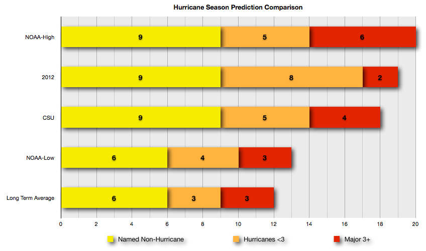
NOAA’s conservative estimates are slightly above the long term average. However, I would say this is not to be expected as the CSU and NOAA high estimates well exceed the long range average of 12 named storms, 6 hurricanes, and 3 major. When comparing the estimates from NOAA and CSU with last year’s actual numbers, the outlook seems to be well within reason.
NOAA points to three key climate factors that will come together to produce an active or extremely active 2013 hurricane season. These are:
- A continuation of the atmospheric climate pattern, which includes a strong west African monsoon, that is responsible for the ongoing era of high activity for Atlantic hurricanes that began in 1995;
- Warmer-than-average water temperatures in the tropical Atlantic Ocean and Caribbean Sea; and
- El Niño is not expected to develop and suppress hurricane formation.
“This year, oceanic and atmospheric conditions in the Atlantic basin are expected to produce more and stronger hurricanes,” said Gerry Bell, Ph.D., lead seasonal hurricane forecaster with NOAA’s Climate Prediction Center. “These conditions include weaker wind shear, warmer Atlantic waters and conducive winds patterns coming from Africa.”
In April, the National Weather Service (NWS) announced some policy changes to allow for hurricane warnings to remain in effect, or to be newly issued, for storms like Sandy that have become post-tropical. This added flexibility will allow forecasters to provide a continuous flow of forecast and warning information for evolving or continuing threats.
Later this summer, the NOAA will bring online a new supercomputer that will run an upgraded Hurricane Weather Research and Forecasting (HWRF) model that provides significantly enhanced depiction of storm structure and improved storm intensity forecast guidance. Additionally, NOAA will received real time Doppler radar data from NOAA’s Hurricane Operations Center Hurricane Hunter aircraft. This live data stream will enhance forecasters ability to analyze rapidly evolving storm conditions, and potentially improve the accuracy of the HWRF model forecasts up to 15%.