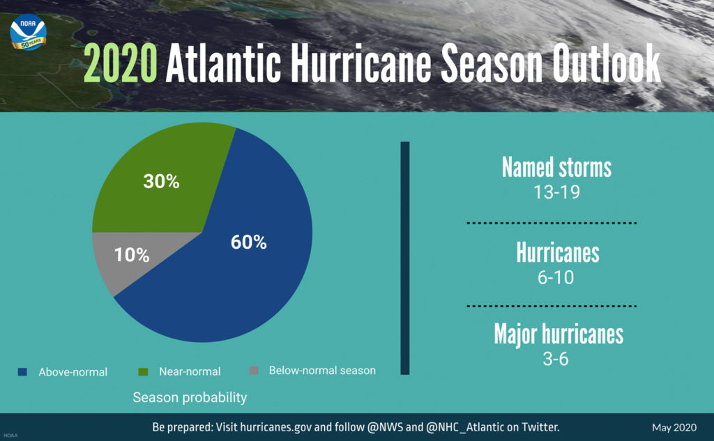
June 1st marks the official start of the 2020 Atlantic Hurricane Season which will continue through November. On May 21st, the National Oceanic and Atmospheric Administration (NOAA) published their outlook for the 2020 Atlantic hurricane season. NOAA predicts that the 2020 Atlantic basin hurricane season will be above-normal.
Forecasters predict a 40% chance of a near-normal season, a 60% chance of an above-normal season, a 30% chance of a near-normal season, and only a 10% chance of a below-normal season.
“NOAA’s analysis of current and seasonal atmospheric conditions reveals a recipe for an active Atlantic hurricane season this year,” said Neil Jacobs, Ph.D., acting NOAA administrator. “Our skilled forecasters, coupled with upgrades to our computer models and observing technologies, will provide accurate and timely forecasts to protect life and property.”
The 2020 outlook reflects several climate factors that are conducive to increased hurricane activity, including the ongoing high-activity era that has been in place since 1995. Forecasters are predicting ENSO neutral or La Niña conditions, along with warmer-than-average sea surface temperatures in the tropical Atlantic Ocean and Caribbean Sea, coupled with reduced vertical wind shear, weaker tropical Atlantic trade winds, and an enhanced west African monsoon.
The 2020 outlook reflects several climate factors driving the strong likelihood for above-normal activity in the Atlantic. El Nino Southern Oscillation (ENSO) conditions are expected to either remain neutral or to trend toward La Nina, meaning there will not be an El Nino present to suppress hurricane activity. Also, warmer-than-average sea surface temperatures in the tropical Atlantic Ocean and Caribbean Sea, coupled with reduced vertical wind shear, weaker tropical Atlantic trade winds, and an enhanced west African monsoon all increase the likelihood for an above-normal Atlantic hurricane season. Similar conditions have been producing more active seasons since the current high-activity era began in 1995.
For 2020, NOAA predicts a likely range of 13 to 19 named storms (winds of 39 mph or higher), of which 6 to 10 could become hurricanes (winds of 74 mph or higher), including 3 to 6 major hurricanes (category 3, 4 or 5; with winds of 111 mph or higher). NOAA provides these ranges with a 70% confidence. An average hurricane season produces 12 named storms, of which 6 become hurricanes, including 3 major hurricanes.
Colorado State University’s Department of Atmospheric Sciences which published their report in April, anticipates that the 2020 Atlantic basin hurricane season will have above-normal activity. The report for 2020 estimates about 8 hurricanes, 16 named storms, and 4 major hurricanes.
CSU anticipates the current warm neutral ENSO conditions appears likely to transition to cool neutral ENSO or potentially even weak La Niña conditions by this summer/fall. Sea surface temperatures averaged across the tropical Atlantic are somewhat above normal. Our Atlantic Multi-decadal Oscillation index is below its long-term average; however, most of the tropical Atlantic is warmer than normal. Colorado State University anticipates an above-average probability for major hurricanes making landfall along the continental United States coastline and in the Caribbean. As is the case with all hurricane seasons, coastal residents are reminded that it only takes one hurricane making landfall to make it an active season for them. They should prepare the same for every season, regardless of how much activity is predicted.
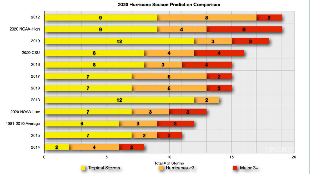
Below is a comparison of the NOAA and Colorado State University’s predictions along with the 1981-2010 average and final numbers for 2012-2019. As you can see, the 2020 NOAA high end lines up with the 2012 season for most named storms. CSU predictions are well above the long term average. Additionally, NOAA’s low end predictions are above the long term average.
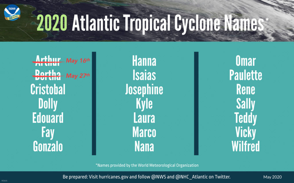
2020 Atlantic Basin Tropical Cyclone Names
- Arthur – Tropical Storm, May 16th
- Bertha – Tropical Storm, May 27th
- Cristobal
- Dolly
- Edouard
- Fay
- Gonzalo
- Hanna
- Isaias
- Josephine
- Kyle
- Laura
- Marco
- Nana
- Omar
- Paulette
- Rene
- Sally
- Teddy
- Vicky
- Wilfred
- Followed by the greek alphabet, if needed.
New for this year, NOAA is also launching new upgrades to products and tools that will further improve critical services during the hurricane season. This includes upgrades to the hurricane-specific Hurricane Weather Research and Forecast system (HWRF) and the Hurricanes in a Multi-scale Ocean coupled Non-hydrostatic (HMON) models. Overall, model accuracy should improve due to data from the COSMIC-2 satellites which provides data about air temperature, pressure and humidity in the tropical regions. Last but not least, NOAA and the U.S. Navy will deploy a fleet of autonomous diving hurricane gliders to observe conditions in the tropical Atlantic Ocean and Caribbean Sea in areas where hurricanes have historically traveled and intensified.
It is important to keep in mind that this annual forecast is a prediction, not what will happen. Mother Nature can, and will do whatever she wants and even the best forecast models will be thrown for a loop. It is imperative to stay alert in the event a system develops and for those living in coastal areas to be prepared.
We will continue to track tropical systems that have the potential to impact cruise itineraries, when they eventually return, as well as frequent Caribbean and Bahamian ports of call. We strive to provide accurate and updated information, but ultimately the best source of up to date information on these systems the National Hurricane Center and your local National Weather Service offices. Basically, what I am saying is that we should not be used as official forecast information. The goal is to share the information from the NHC and how it relates or impacts it may have on sailings and ports of call.
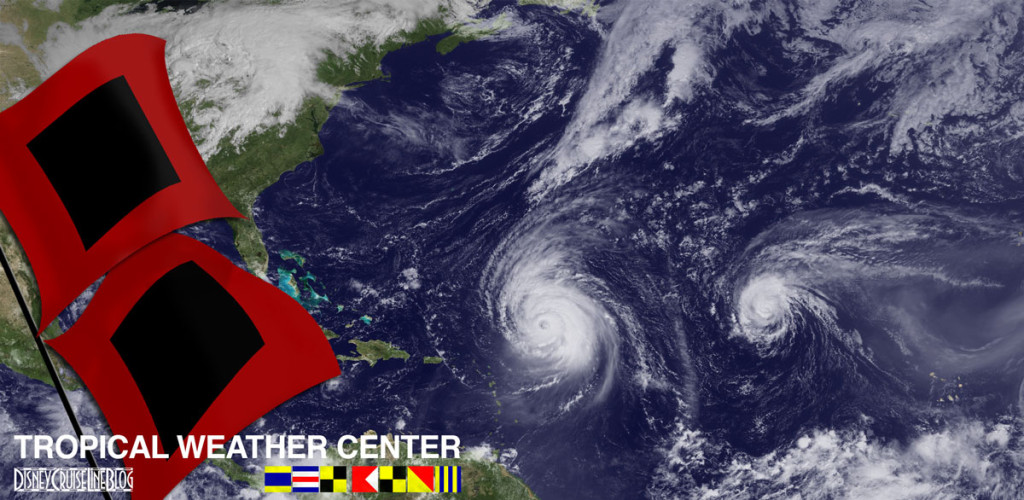
We have been covering hurricane season since the website launched and have a dedicated Tropical Weather page.


