
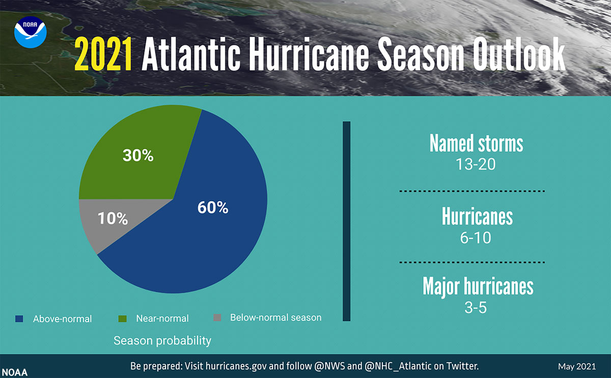
June 1st marks the official start of the 2021 Atlantic Hurricane Season which will continue through November. On May 20th, the National Oceanic and Atmospheric Administration (NOAA) published their outlook for the 2021 Atlantic hurricane season. NOAA predicts that the 2021 Atlantic basin hurricane season will be above-normal.
Forecasters predict a 60% chance of an above-normal season, a 30% chance of a near-normal season, and a 10% chance of a below-normal season. However, experts do not anticipate the historic level of storm activity seen in 2020.
“Although NOAA scientists don’t expect this season to be as busy as last year, it only takes one storm to devastate a community,” said Ben Friedman, acting NOAA administrator. “The forecasters at the National Hurricane Center are well-prepared with significant upgrades to our computer models, emerging observation techniques, and the expertise to deliver the life-saving forecasts that we all depend on during this, and every, hurricane season.”
El Nino Southern Oscillation (ENSO) conditions are currently in the neutral phase, with the possibility of the return of La Nina later in the hurricane season.
“ENSO-neutral and La Nina support the conditions associated with the ongoing high-activity era,” said Matthew Rosencrans, lead seasonal hurricane forecaster at NOAA’s Climate Prediction Center. “Predicted warmer-than-average sea surface temperatures in the tropical Atlantic Ocean and Caribbean Sea, weaker tropical Atlantic trade winds, and an enhanced west African monsoon will likely be factors in this year’s overall activity.”
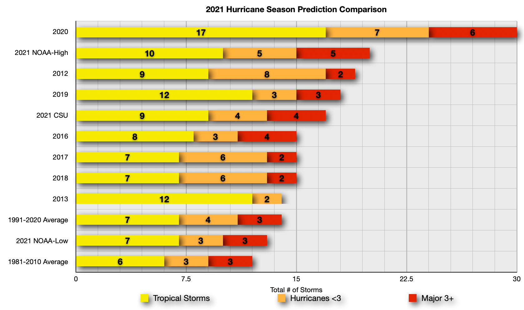
For 2021, NOAA predicts a likely range of 13 to 20 named storms (winds of 39 mph or higher), of which 6 to 10 could become hurricanes (winds of 74 mph or higher), including 3 to 5 major hurricanes (category 3, 4 or 5; with winds of 111 mph or higher). NOAA provides these ranges with a 70% confidence. An average hurricane season produces 12 named storms, of which 6 become hurricanes, including 3 major hurricanes.
Colorado State University’s Department of Atmospheric Sciences which published their report in April, is similar to NOAA’s outlook as they to anticipate the 2021 Atlantic basin hurricane season will have above-normal activity. The report for 2021 estimates about 8 hurricanes, 17 named storms, and 4 major hurricanes.
CSU anticipates the current weak La Niña conditions may transition to neutral ENSO by this summer/fall, but the odds of a significant El Niño seem unlikely. Sea surface temperatures averaged across the tropical Atlantic are currently near average, while subtropical Atlantic sea surface temperatures are warmer than normal. CSU anticipates an above-average probability for major hurricanes making landfall along the continental United States coastline and in the Caribbean.
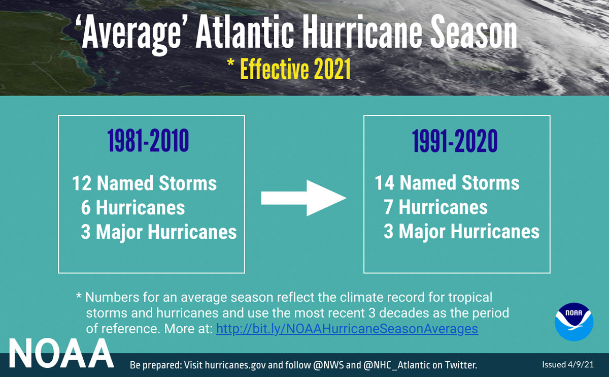
In early April, NOAA revised their definition of “Average” moving the 30-year average from 1981-2010 to 1991-2020. Effective this year, the updated averages for the Atlantic hurricane season have increased with 14 named storms and 7 hurricanes. The average for major hurricanes remains unchanged at 3.
Below is a comparison of the NOAA and Colorado State University’s predictions along with the new 1991-2020 average and final numbers for 2012-2020. As you can see, the 2021 NOAA high comes in well below the record setting 2020 season where we saw 30 named storms develop in the Atlantic Basin. CSU predictions are above the new long term average. NOAA’s low end predictions are sandwiched between the new and old long term average.
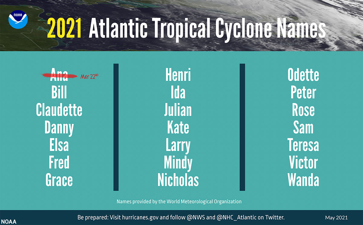
2021 Atlantic Basin Tropical Cyclone Names
- Ana – Tropical Storm – May 22, 2021
- Bill
- Claudette
- Danny
- Elsa
- Fred
- Grace
- Henri
- Ida
- Julian
- Kate
- Larry
- Mindy
- Nicholas
- Odette
- Peter
- Rose
- Sam
- Teresa
- Victor
- Wanda
- Followed by the greek alphabet, if needed.
New for this year, NOAA made several updates to products and services that will improve hurricane forecasting during the 2021 season.
- In March, NOAA upgraded the flagship Global Forecast System (GFS) to improve hurricane genesis forecasting and coupled GFS with a wave model extending ocean wave forecasts from 10 days out to 16 days. Additionally, Global Positioning Satellite Radio Occultation (GPS-RO) data are now included in the GFS model, providing an additional source of observations to strengthen overall model performance.
- Forecasters at the National Hurricane Center are now using an upgraded probabilistic storm surge model — known as P-Surge — which includes improved tropical cyclone wind structure and storm size information that offers better predictability and accuracy. This upgrade extends the lead time of P-Surge forecast guidance from 48 to 60 hours in situations where there is high confidence.
- NOAA’s Atlantic Oceanographic and Meteorological Laboratory will deploy its largest array of air and water uncrewed systems to gather data designed to help improve hurricane intensity forecasts and forecast models. New drones will be launched from NOAA Hurricane Hunter aircraft that will fly into the lower part of hurricanes, and in the ocean, saildrones, hurricane gliders, global drifters, and air-deployable technology — called ALAMO floats — will track various parts of the life cycle of tropical storms.
It is important to keep in mind that these annual forecasts are just predictions, not what will happen. Mother Nature can, and will do whatever she wants and even the best forecast models will be thrown for a loop. It is imperative to stay alert in the event a system develops and for those living in coastal areas to be prepared.
We will continue to track tropical systems that have the potential to impact cruise itineraries, when they eventually return, as well as frequent Caribbean and Bahamian ports of call. We strive to provide accurate and updated information, but ultimately the best source of up to date information on these systems the National Hurricane Center and your local National Weather Service offices. Basically, what I am saying is that we should not be used as official forecast information. The goal is to share the information from the NHC and how it relates or impacts it may have on sailings and ports of call.
We have been covering hurricane season since the website launched and have a dedicated Tropical Weather page.