June 1st marks the official start of the 2022 Atlantic Hurricane Season which will continue through November. On May 24th, the National Oceanic and Atmospheric Administration (NOAA) published their outlook for the 2022 Atlantic hurricane season. NOAA predicts that the 2022 Atlantic basin hurricane season will be above-normal due in part to the ongoing La Niña cycle resulting in above-average Atlantic temperatures.
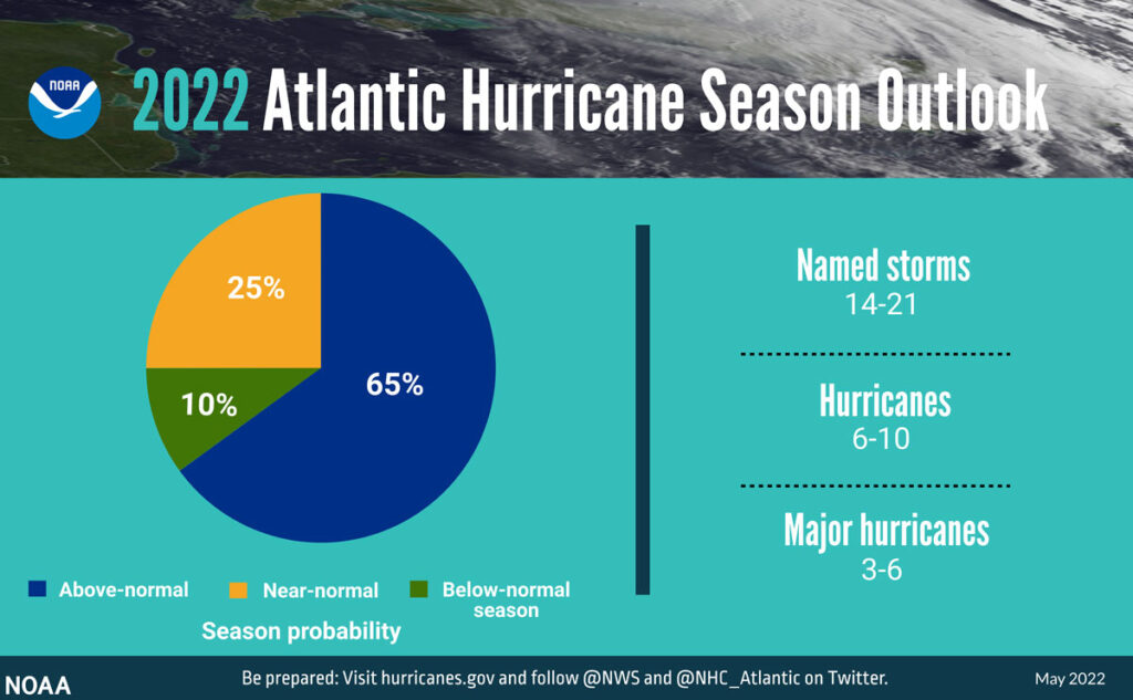
Forecasters at NOAA’s Climate Prediction Center, a division of the National Weather Service, are predicting above-average hurricane activity this year — which would make it the seventh consecutive above-average hurricane season. NOAA’s outlook for the 2022 Atlantic hurricane season predicts a 65% chance of an above-normal season, a 25% chance of a near-normal season and a 10% chance of a below-normal season.

For the 2022 hurricane season, NOAA is forecasting a likely range of 14 to 21 named storms (winds of 39 mph or higher), of which 6 to 10 could become hurricanes (winds of 74 mph or higher), including 3 to 6 major hurricanes (category 3, 4 or 5; with winds of 111 mph or higher). NOAA provides these ranges with a 70% confidence.
“Early preparation and understanding your risk is key to being hurricane resilient and climate-ready,” said Secretary of Commerce Gina M. Raimondo. “Throughout the hurricane season, NOAA experts will work around-the-clock to provide early and accurate forecasts and warnings that communities in the path of storms can depend on to stay informed.”
The increased activity anticipated this hurricane season is attributed to several climate factors, including the ongoing La Niña that is likely to persist throughout the hurricane season, warmer-than-average sea surface temperatures in the Atlantic Ocean and Caribbean Sea, weaker tropical Atlantic trade winds and an enhanced west African monsoon. An enhanced west African monsoon supports stronger African Easterly Waves, which seed many of the strongest and longest lived hurricanes during most seasons. The way in which climate change impacts the strength and frequency of tropical cyclones is a continuous area of study for NOAA scientists.
Colorado State University’s Department of Atmospheric Sciences which published their report in April, is similar to NOAA’s outlook as they to anticipate the 2022 Atlantic basin hurricane season will have above-normal activity. The report for 2022 estimates about 9 hurricanes, 19 named storms, and 4 major hurricanes.
CSU anticipates that the 2022 Atlantic basin hurricane season will have above-normal activity. Current weak La Niña conditions look fairly likely to transition to neutral ENSO by this summer/fall, but the odds of a significant El Niño seem unlikely. Sea surface temperatures averaged across the eastern and central tropical Atlantic are currently near average, while Caribbean and subtropical Atlantic sea surface temperatures are warmer than normal. We anticipate an above-average probability for major hurricanes making landfall along the continental United States coastline and in the Caribbean. As is the case with all hurricane seasons, coastal residents are reminded that it only takes one hurricane making landfall to make it an active season for them. They should prepare the same for every season, regardless of how much activity is predicted.
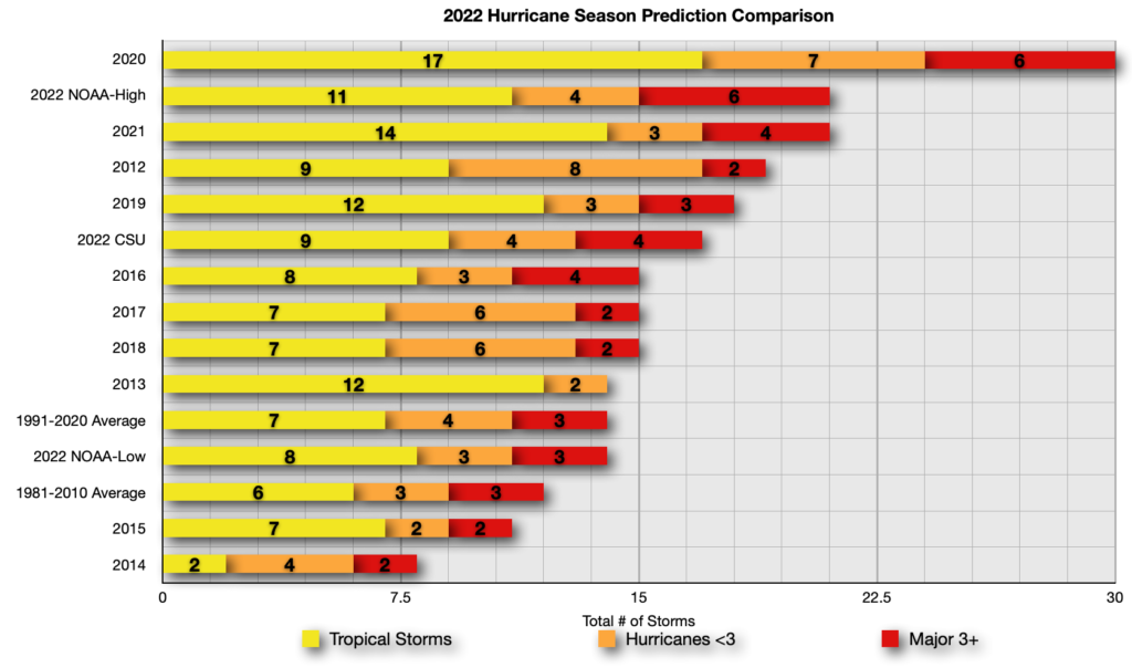
Below is a comparison of the NOAA and Colorado State University’s predictions along with the 1991-2020 average and final numbers for 2012-2021. As you can see, the 2022 NOAA high comes in well below the record setting 2020 season where we saw 30 named storms develop in the Atlantic Basin. CSU predictions are above the new long term average. NOAA’s low end predictions are sandwiched between the new and old long term average.

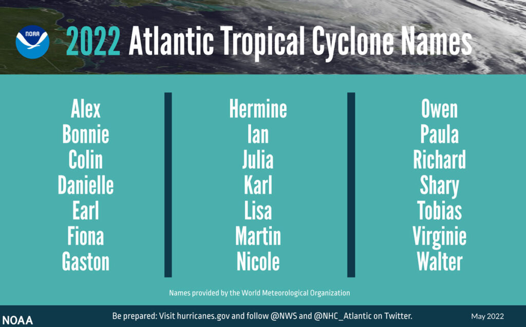
2022 Atlantic Basin Tropical Cyclone Names
- Alex
- Bonnie
- Colin
- Danielle
- Earl
- Fiona
- Gaston
- Hermine
- Ian
- Julia
- Karl
- Lisa
- Martin
- Nichole
- Owen
- Paula
- Richard
- Shary
- Tobias
- Virginie
- Walter
- Followed by the greek alphabet, if needed.

New for this year, NOAA made several updates to products and services that will improve hurricane forecasting during the 2022 season.
- To improve the understanding and prediction of how hurricanes intensify, NOAA’s Atlantic Oceanographic and Meteorological Lab and Pacific Marine Environmental Lab will operate five Saildrone uncrewed surface vehicles during the peak of the 2022 hurricane season and coordinate for the first time with uncrewed ocean gliders, small aircraft drone systems, and NOAA Hurricane Hunter aircraft to measure the ocean, atmosphere and areas where they meet.
- The Hurricane Weather Research and Forecast Modeling System and Hurricanes in a Multi-scale Ocean-coupled Non-hydrostatic model, which have shown significant skill improvements in terms of storm track and intensity forecasts, have been successfully transitioned to the newest version of the Weather and Climate Operational Supercomputing System, allowing for uninterrupted operational forecasts.
- The Excessive Rainfall Outlook (ERO) has been experimentally extended from three to five days of lead time, giving more notice of rainfall-related flash flooding risks from tropical storms and hurricanes. The ERO forecasts and maps the probability of intense rainfall that could lead to flash flooding within 25 miles of a given point.
- In June, NOAA will enhance an experimental graphic that depicts the Peak Storm Surge Forecast when storm surge watches or warnings are in effect. Upgrades include an updated disclaimer and color coding that illustrates the peak storm surge inundation forecast at the coast. This tool is currently only available in the Atlantic basin.
It is important to keep in mind that these annual forecasts are just predictions, not what will happen. Mother Nature can, and will do whatever she wants and even the best forecast models will be thrown for a loop. It is imperative to stay alert in the event a system develops and for those living in coastal areas to be prepared. NOAA’s outlook is for overall seasonal activity and is not a landfall forecast
We will continue to track tropical systems that have the potential to impact cruise itineraries, when they eventually return, as well as frequent Caribbean and Bahamian ports of call. We strive to provide accurate and updated information, but ultimately the best source of up to date information on these systems the National Hurricane Center and your local National Weather Service offices. Basically, what I am saying is that we should not be used as official forecast information. The goal is to share the information from the NHC and how it relates or impacts it may have on sailings and ports of call.
We have been covering hurricane season since the website launched and have a dedicated Tropical Weather page.
Historical Hurricane Season Outlooks
- 2013 – NOAA Predicts an Above Average 2013 Atlantic Hurricane Season
- 2014 – NOAA Predicts Near to Below Normal 2014 Atlantic Hurricane Season
- 2015 – NOAA Predicts Below Normal 2015 Atlantic Hurricane Season
- 2016 – NOAA Predicts Near-Normal 2016 Atlantic Hurricane Season
- 2017 – NOAA Predicts Above-Normal 2017 Atlantic Hurricane Season
- 2018 – NOAA Predicts Near or Above-Normal 2018 Atlantic Hurricane Season
- 2019 – NOAA Predicts Near-Normal 2019 Atlantic Hurricane Season
- 2020 – NOAA Predicts an Above-Normal 2020 Atlantic Hurricane Season
- 2021 – NOAA Predicts an Above-Normal 2021 Atlantic Hurricane Season
- 2022 – NOAA Predicts an Above-Normal 2022 Atlantic Hurricane Season


This indeed was very true, I mean, look at Florida. Hope the residents are keeping safe.