
Today, June 1st, marks the official start of the 2024 Atlantic Hurricane Season which will continue through November. On May 23rd, the National Oceanic and Atmospheric Administration (NOAA) published their outlook for the 2024 Atlantic hurricane season. NOAA predicts that the 2024 Atlantic basin hurricane season will be above-normal due in part to La Niña and warmer than average Atlantic Ocean surface temperatures.
Forecasters at NOAA’s Climate Prediction Center, a division of the National Weather Service, predict above-normal hurricane activity in the Atlantic basin this year. NOAA’s outlook for the 2024 Atlantic hurricane season, predicts an 85% chance of an above-normal season, a 10% chance of a near-normal season and a 5% chance of a below-normal season.
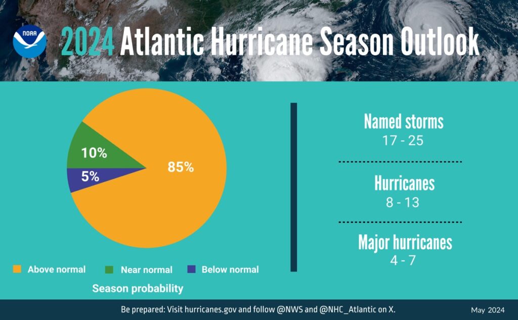
For the 2024 hurricane season, NOAA is forecasting a range of 17 to 25 total named storms (winds of 39 mph or higher). Of those, 8 to 13 are forecast to become hurricanes (winds of 74 mph or higher), including 4 to 7 major hurricanes (category 3, 4 or 5; with winds of 111 mph or higher). Forecasters have a 70% confidence in these ranges.
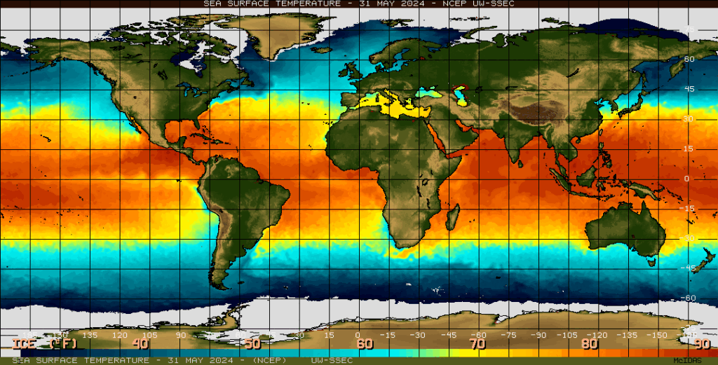
The upcoming Atlantic hurricane season is expected to have above-normal activity due to a confluence of factors, including near-record warm ocean temperatures in the Atlantic Ocean, development of La Nina conditions in the Pacific, reduced Atlantic trade winds and less wind shear, all of which tend to favor tropical storm formation.
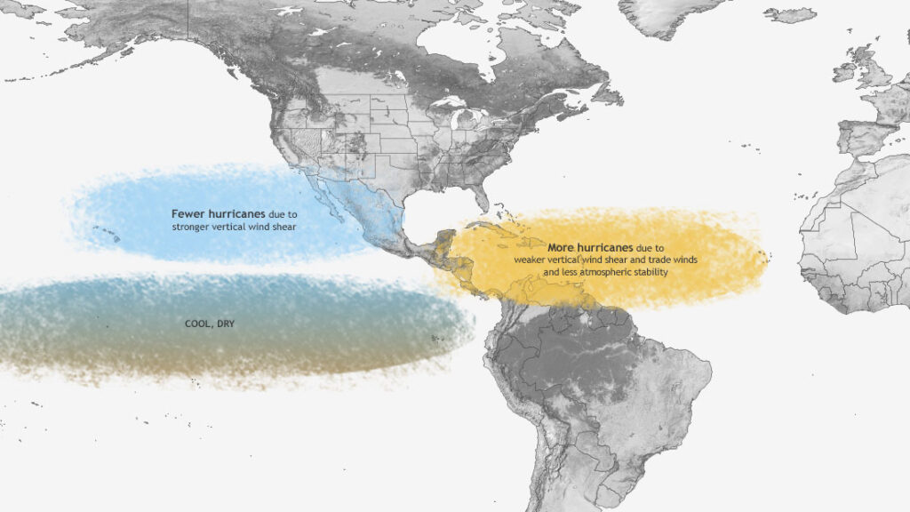
(Typical influence of La Niña on Pacific and Atlantic seasonal hurricane activity. Map by NOAA Climate.gov, based on originals by Gerry Bell.)
As one of the strongest El Ninos ever observed nears its end, NOAA scientists predict a quick transition to La Nina conditions, which are conducive to Atlantic hurricane activity because La Nina tends to lessen wind shear in the tropics.
At the same time, abundant oceanic heat content in the tropical Atlantic Ocean and Caribbean Sea creates more energy to fuel storm development.
This hurricane season also features the potential for an above-normal west African monsoon, which can produce African easterly waves that seed some of the strongest and longer-lived Atlantic storms. Finally, light trade winds allow hurricanes to grow in strength without the disruption of strong wind shear, and also minimize ocean cooling. Human-caused climate change is warming our ocean globally and in the Atlantic basin, and melting ice on land, leading to sea level rise, which increases the risk of storm surge. Sea level rise represents a clear human influence on the damage potential from a given hurricane.
Colorado State University’s (CSU) Department of Atmospheric Sciences which published their report in April, is similar to NOAA’s outlook as they to anticipate the 2024 Atlantic basin hurricane season to be “extremely active.” The report for 2024 estimates about 11 hurricanes, 23 named storms, and 5 major hurricanes. CSU’s report expects a well above-average probability for major hurricanes making landfall along the continental United States coastline and in the Caribbean.
According to the CSU forecast, the current El Niño conditions are likely to transition to La Niña conditions this summer/fall, leading to hurricane-favorable wind shear conditions. Sea surface temperatures in the eastern and central Atlantic are currently at record warm levels and are anticipated to remain well above average for the upcoming hurricane season. A warmer-than-normal tropical Atlantic provides a more conducive dynamic and thermodynamic environment for hurricane formation and intensification.
The Atlantic basin saw 20 named storms in 2023, which ranks fourth for the most-named storms in a year since 1950. Seven storms were hurricanes and three intensified to major hurricanes. An average season has 14 named storms, seven hurricanes and three major hurricanes.
Below is a comparison of the 2024 NOAA and Colorado State University’s predictions along with the 1981-2010 long term average, 1991-2020 long term average, and final numbers for 2012-2023.
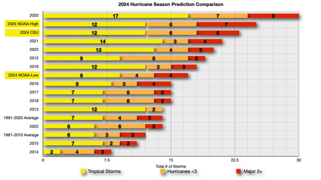
As you can see, the 2024 NOAA-High is just behind the record setting 2020 season which had 30 named storms develop in the Atlantic Basin. CSU predictions are just behind NOAA-High with NOAA’s low end predictions above the long term average.
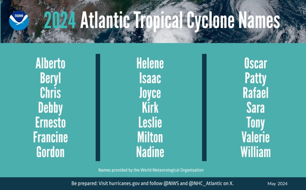
2024 Atlantic Basin Tropical Cyclone Names and Pronunciations
NHC’s tropical cyclone advisory archive for the following potential named storms can be viewed here. The name pronunciation is in parentheses. A full list of Atlantic basin tropical cyclone name pronunciations through 2029 can be found here.
- Alberto (al-BAIR-toe)
- Beryl (BEHR-ril)
- Chris (kris)
- Debby (DEH-bee)
- Ernesto (er-NES-toh)
- Francine (fran-SEEN)
- Gordon (GOR-duhn)
- Helene (heh-LEEN)
- Isaac (EYE-zik)
- Joyce (joyss)
- Kirk (kurk)
- Leslie (LEHZ-lee)
- Milton (MIL-ton)
- Nadine (nay-DEEN)
- Oscar (AHS-kur)
- Patty (PAT-ee)
- Rafael (Rah-fah-EL)
- Sara (SAIR-uh)
- Tony (TOH-nee)
- Valerie (VAH-lur-ee)
- William (Will-yum)
- Followed by the greek alphabet, if needed.
For this year, NOAA will implement improvements to its forecast communications, decision support and storm recovery efforts this season. These include:
- The National Hurricane Center (NHC) will expand its offering of Spanish language text products to include all Public Advisories, the Tropical Cyclone Discussion, the Tropical Cyclone Update and Key Messages in the Atlantic basin.
- Beginning on or around August 15, NHC will start to issue an experimental version of the forecast cone graphic that includes a depiction of inland tropical storm and hurricane watches and warnings in effect for the continental U.S. Research indicates that the addition of inland watches and warnings to the cone graphic will help communicate inland hazards during tropical cyclone events without overcomplicating the current version of the graphic.
- This season, the NHC will be able to issue U.S. tropical cyclone watches and warnings with regular or intermediate public advisories. This means that if updates to watches and warnings for storm surge or winds are needed, the NHC will be able to notify the public in an intermediate advisory instead of having to wait for the next full advisory issued every 6 hours.
“With another active hurricane season approaching, NOAA’s commitment to keeping every American informed with life-saving information is unwavering,” said NOAA Administrator Rick Spinrad, Ph.D. “AI-enabled language translations and a new depiction of inland wind threats in the forecast cone are just two examples of the proactive steps our agency is taking to meet our mission of saving lives and protecting property.”
“Severe weather and emergencies can happen at any moment, which is why individuals and communities need to be prepared today,” said FEMA Deputy Administrator Erik A. Hooks. “Already, we are seeing storms move across the country that can bring additional hazards like tornadoes, flooding and hail. Taking a proactive approach to our increasingly challenging climate landscape today can make a difference in how people can recover tomorrow.”
It is important to keep in mind that these annual forecasts are just predictions, not what will happen. Mother Nature can, and will do whatever she wants and even the best forecast models will be thrown for a loop. It is imperative to stay alert in the event a system develops and for those living in coastal areas to be prepared. NOAA’s outlook is for overall seasonal activity and is not a landfall forecast. The majority of coverage focuses on the landfalls, but these systems can also impact the cruise industry causing ships to alter itineraries, and change course to avoid the forecast track and associated rough seas.
We will continue to track tropical systems that have the potential to impact cruise itineraries, as well as frequent Caribbean and Bahamian ports of call. We strive to provide accurate and updated information, but ultimately the best source of up to date information on these systems the National Hurricane Center and your local National Weather Service offices. Basically, what I am saying is that we should not be used as official forecast information. The goal is to share the information from the NHC and how it relates or impacts it may have on sailings and ports of call.
We have been covering hurricane season since the website launched and have a dedicated Tropical Weather page.
Historical Hurricane Season Outlooks
- 2013 – NOAA Predicts an Above Average 2013 Atlantic Hurricane Season
- 2014 – NOAA Predicts Near to Below Normal 2014 Atlantic Hurricane Season
- 2015 – NOAA Predicts Below Normal 2015 Atlantic Hurricane Season
- 2016 – NOAA Predicts Near-Normal 2016 Atlantic Hurricane Season
- 2017 – NOAA Predicts Above-Normal 2017 Atlantic Hurricane Season
- 2018 – NOAA Predicts Near or Above-Normal 2018 Atlantic Hurricane Season
- 2019 – NOAA Predicts Near-Normal 2019 Atlantic Hurricane Season
- 2020 – NOAA Predicts an Above-Normal 2020 Atlantic Hurricane Season
- 2021 – NOAA Predicts an Above-Normal 2021 Atlantic Hurricane Season
- 2022 – NOAA Predicts an Above-Normal 2022 Atlantic Hurricane Season
- 2023 – NOAA Predicts an Near-Normal 2023 Atlantic Hurricane Season
- 2024 – NOAA Predicts an Above-Normal 2024 Atlantic Hurricane Season
Got to justify there jobs. 79 years of hurricanes wrong more than right.
They have only been doing seasonal outlooks for maybe the last 25 years. If you you look at the last 10 years, NOAA and CSU have been pretty accurate. https://www.wfla.com/weather/tracking-the-tropics/tracking-the-tropics-how-accurate-are-hurricane-season-forecasts/#:~:text=Turns%20out%2C%20the%20preseason%20forecasts,storms%20for%20that%20same%20period.
I think people get caught up in the sensationalized over-hype articles that pop up as a result of these outlooks.