
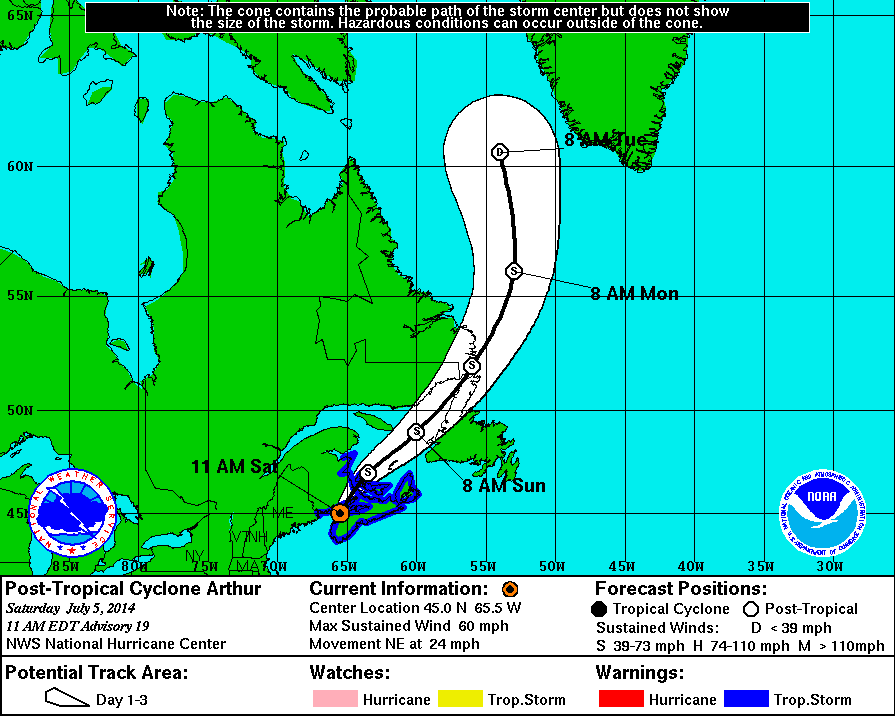
11 AM Update | NHC Issues Final Advisory – Canadian Hurricane Centre To Issue Future Statements
As Arthur continues to bring strong winds and heavy faints over portions of southeastern Canada through tonight. The National Hurricane Center issued the final advisory on Arthur this hour and all future statements will be issued by the Canadian Hurricane Centre. Arthur is moving northeast at 24 mph with maximum sustained winds of 60 mph with a minimum pressure of 983 mb. Gale force winds are extending outward 205 miles.
Arthur is expected to weaken over the next couple of days. Tropical storm warnings are in effect in Canada, pictured below in blue.
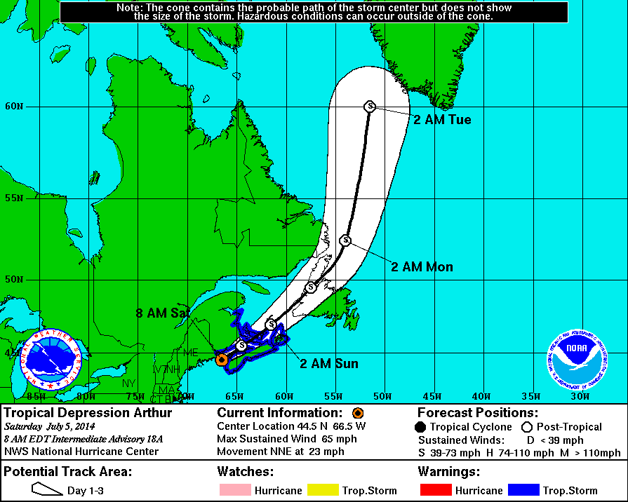
8 AM Update | Arthur Becomes a Post-Tropical Cyclone
As Arthur races north-northeast at 23 mph, he continues to degrade. NHC recently downgraded the system to a post-tropical cyclone. Arthur is located about 50 miles north-northwest of Yarmouth, Nova Scotia with maximum sustained winds of 65 mph and a central pressure at 983 mb. Gale force winds are extending 16o miles from the center and a gust of 54 mph was reported at Luneburg, Nova Scotia.
Arthur is expected to weaken over the next couple of days as well as a decrease in forward speed. Tropical storm warnings are in effect in Canada, pictured below in blue.
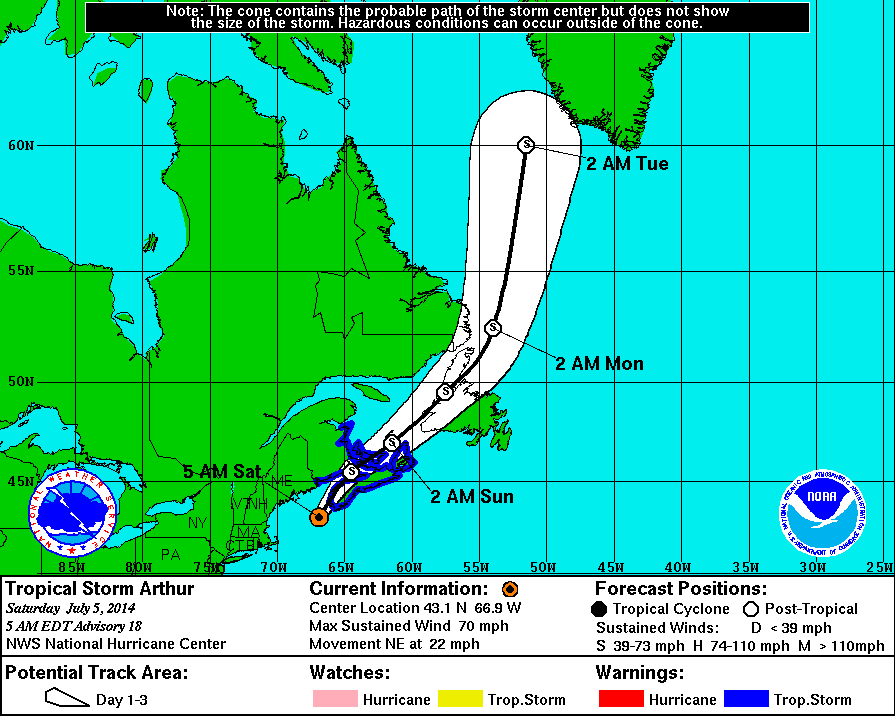
5 AM Update | Hurricane Arthur Weakens to a Tropical Storm Near Nova Scotia
Hurricane Arthur is no more. Arthur has weakened back to a tropical storm with maximum sustained winds of 70 mph and a pressure increase to 981 mb. Arthur’s tropical storm force winds are reaching 160 from the center. Presently, TS Arthur is located 65 miles southwest of Yarmouth, Nova Scotia.
Tropical Cyclone History | Arthur
This table contains the NHC’s statistics for the tropical cyclone from each advisory.
| Date | Time (EST) | Classification | Max Winds (mph) | Movement/Speed | Pressure (mb) |
| June 28 | — | Invest 91L | |||
| June 30 | 11 PM | Tropical Depression | 35 | SW at 2 mph | 1009 |
| July 1 | 2 AM | 35 | SW at 2 mph | 1009 | |
| 5 AM | 35 | W at 2 mph | 1008 | ||
| 8 AM | 35 | Stationary | 1007 | ||
| 11 AM | Tropical Storm | 40 | NW at 2 mph | 1007 | |
| 2 PM | 40 | NW at 5 mph | 1007 | ||
| 5 PM | 50 | NW at 2 mph | 1003 | ||
| 8 PM | 50 | Stationary | 1003 | ||
| 11 PM | 50 | N at 2 mph | 1003 | ||
| July 2 | 2 AM | 60 | N at 4 mph | 1001 | |
| 5 AM | 60 | N at 6 mph | 996 | ||
| 8 AM | 60 | N at 6 mph | 998 | ||
| 11 AM | 60 | N at 7 mph | 997 | ||
| 2 PM | 60 | N at 7 mph | 997 | ||
| 5 PM | 70 | N at 7 mph | 992 | ||
| 8 PM | 70 | N at 8 mph | 990 | ||
| 11 PM | 70 | N at 8 mph | 988 | ||
| July 3 | 2 AM | 70 | N at 8 mph | 988 | |
| 5 AM | Hurricane Category 1 |
75 | N at 9 mph | 985 | |
| 8 AM | 80 | NNE at 9 mph | 983 | ||
| 11 AM | 90 | NNE at 10 mph | 981 | ||
| 2 PM | 90 | NNE at 13 mph | 980 | ||
| 5 PM | 90 | NNE at 13 mph | 977 | ||
| 7 PM | 90 | NNE at 15 mph | 977 | ||
| 8 PM | 90 | NNE at 15 mph | 997 | ||
| 9 PM | Hurricane Category 2 |
100 | NNE at 15 mph | 976 | |
| 11 PM | 100 | NE at 18 mph | 976 | ||
| July 4 | 1 AM | 100 | NE at 18 mph | 976 | |
| 3 AM | 100 | NE at 22 mph | 973 | ||
| 7 AM | 100 | NE at 23 mph | 973 | ||
| 11 AM | Hurricane | 90 | NE at 24 mph | 976 | |
| 2 PM | 90 | NE at 25 mph | 977 | ||
| 5 PM | 80 | NE at 26 mph | 979 | ||
| 11 PM | 75 | NE at 31 mph | 976 | ||
| July 5 | 2 AM | 75 | NE at 31 mph | 981 | |
| 5 AM | Tropical Storm | 70 | NE at 22 mph | 981 | |
| 8 AM | Post-Tropical Cyclone | 65 | NNE at 23 mph | 983 | |
| 11 AM | 60 | NE at 24 mph | 983 | ||