
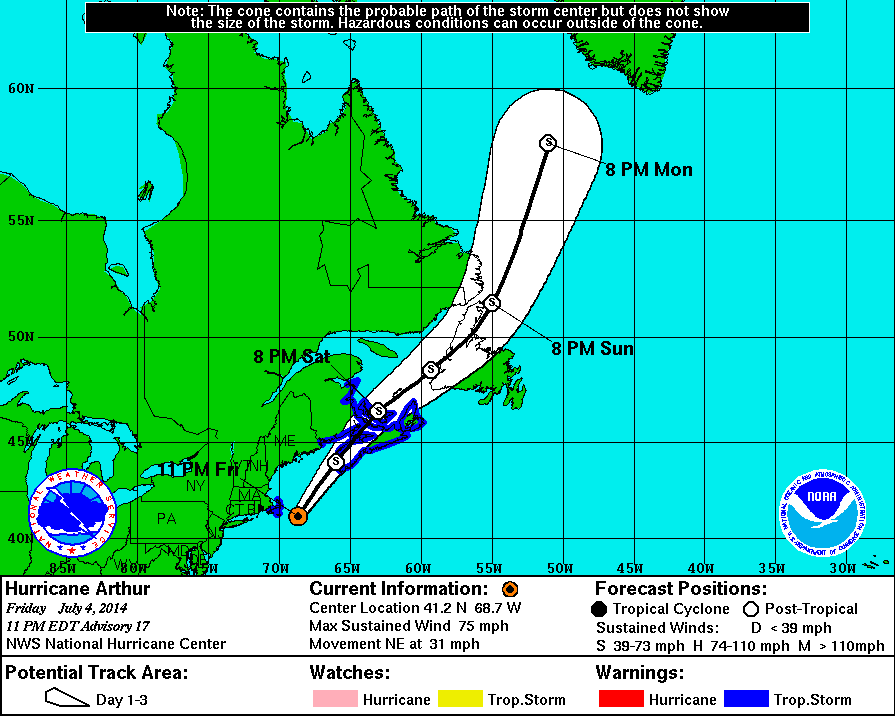
11 PM Update | Arthur Barely a Hurricane – TS Conditions over Nantucket
Hurricane Arthur barely at hurricane strength with maximum sustained winds of 75 mph and a minimum central pressure of 976 mb. Arthur is located 75 miles east-southeast of Chatham, Massachusetts moving towards the northeast at 31 mph. Hurricane force winds are extending 70 miles out with tropical storm force winds reaching 160 from the center.
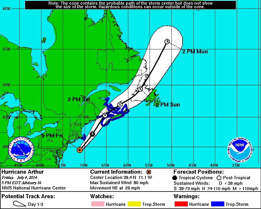
5 PM Update | Tropical Storm Force Winds Expected over Cape Cod & Nantucket Later Tonight
Hurricane Arthur is 170 miles south-southwest of Chatham, Massachusetts heading northeast at 26 mph. Arthur is weakening, but is still a category 1 hurricane with maximum sustained winds of 80 mph and a pressure of 979 mb. Arthur is over water, hurricane force winds are extending 70 miles out with tropical storm force winds reaching 160 from the center.
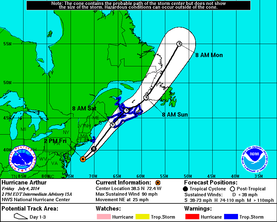
2 PM Update | Arthur Passing Well East of Mid-Atlantic Coast
Hurricane Arthur is about 100 miles east-southeast of Ocean City, Maryland heading northeast at 24 mph. Arthur is now a category 1 hurricane with maximum sustained winds of 90 mph and a pressure of 977 mb. Arthur is over water, hurricane force winds are extending 40 miles out with tropical storm force winds reaching 125 from the center.
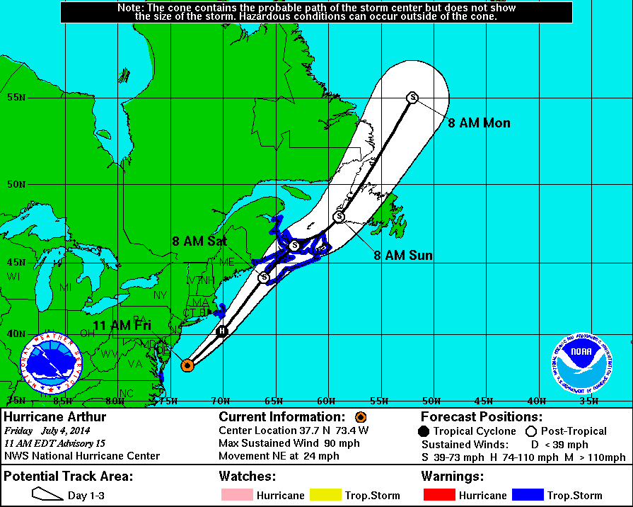
11 AM Update | All Warnings in North Carolina Discontinued
Hurricane Arthur is about 100 miles east-southeast of Ocean City, Maryland heading northeast at 24 mph. Arthur is now a category 1 hurricane with maximum sustained winds of 90 mph and a pressure of 976 mb. Arthur is over water, hurricane force winds are extending 40 miles out with tropical storm force winds reaching 125 from the center.
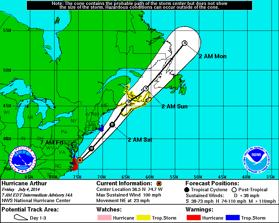
7 AM Update | Arthur Strengthens to Category 2 Hurricane
Hurricane Arthur is back over the Atlantic ocean about 65 miles east-northeast of Kitty Hawk, North Carolina heading northeast at 23 mph. Arthur remains a category 2 hurricane with maximum sustained winds of 100 mph and a pressure of 973 mb. Arthur is expected to increase forward speed over the next two days along the forecast track. Although Arthur is over water, hurricane force winds are extending 40 miles out with tropical storm force winds reaching 125 from the center.
Arthur’s forecast track has him skirting the New England coast and looks to loose steam late Saturday night as it makes another landfall in Nova Scotia. Model runs suggest it will degrade to a post-tropical storm by early Sunday morning.
Tropical Cyclone History | Arthur
This table contains the NHC’s statistics for the tropical cyclone from each advisory.
| Date | Time (EST) | Classification | Max Winds (mph) | Movement/Speed | Pressure (mb) |
| June 28 | — | Invest 91L | |||
| June 30 | 11 PM | Tropical Depression | 35 | SW at 2 mph | 1009 |
| July 1 | 2 AM | 35 | SW at 2 mph | 1009 | |
| 5 AM | 35 | W at 2 mph | 1008 | ||
| 8 AM | 35 | Stationary | 1007 | ||
| 11 AM | Tropical Storm | 40 | NW at 2 mph | 1007 | |
| 2 PM | 40 | NW at 5 mph | 1007 | ||
| 5 PM | 50 | NW at 2 mph | 1003 | ||
| 8 PM | 50 | Stationary | 1003 | ||
| 11 PM | 50 | N at 2 mph | 1003 | ||
| July 2 | 2 AM | 60 | N at 4 mph | 1001 | |
| 5 AM | 60 | N at 6 mph | 996 | ||
| 8 AM | 60 | N at 6 mph | 998 | ||
| 11 AM | 60 | N at 7 mph | 997 | ||
| 2 PM | 60 | N at 7 mph | 997 | ||
| 5 PM | 70 | N at 7 mph | 992 | ||
| 8 PM | 70 | N at 8 mph | 990 | ||
| 11 PM | 70 | N at 8 mph | 988 | ||
| July 3 | 2 AM | 70 | N at 8 mph | 988 | |
| 5 AM | Hurricane Category 1 |
75 | N at 9 mph | 985 | |
| 8 AM | 80 | NNE at 9 mph | 983 | ||
| 11 AM | 90 | NNE at 10 mph | 981 | ||
| 2 PM | 90 | NNE at 13 mph | 980 | ||
| 5 PM | 90 | NNE at 13 mph | 977 | ||
| 7 PM | 90 | NNE at 15 mph | 977 | ||
| 8 PM | 90 | NNE at 15 mph | 997 | ||
| 9 PM | Hurricane Category 2 |
100 | NNE at 15 mph | 976 | |
| 11 PM | 100 | NE at 18 mph | 976 | ||
| July 4 | 1 AM | 100 | NE at 18 mph | 976 | |
| 3 AM | 100 | NE at 22 mph | 973 | ||
| 7 AM | 100 | NE at 23 mph | 973 | ||
| 11 AM | Hurricane | 90 | NE at 24 mph | 976 | |
| 2 PM | 90 | NE at 25 mph | 977 | ||
| 5 PM | 80 | NE at 26 mph | 979 | ||
| 11 PM | 75 | NE at 31 mph | 976 | ||