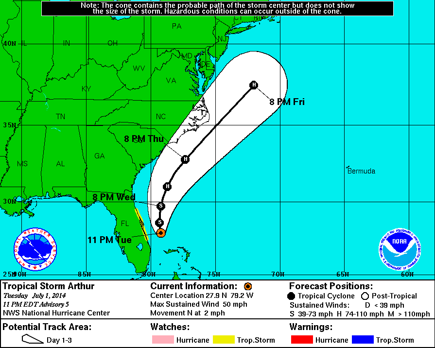
11 PM Update | Tropical Storm Arthur Drifting Northward
Tropical Storm Arthur continues to hang out off the east coast of Florida approximately 90 miles east-southeast of Cape Canaveral, but is now slowly moving north at 2 mph. Maximum sustained winds are still clocking in at 50 mph. Tropical storm force winds are extending outward 70 miles from the center of TS Arthur. The minimum central pressure is holding at 1003 mb.
There are no changes to the tropical storm watch which remains in effect along the east coast of Florida from Fort Pierce to Flagler Beach. The TS watch includes includes Port Canaveral but as of now is still open for business as usual.
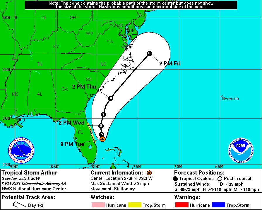
8 PM Intermediate Update | Tropical Storm Arthur Strengthening
Tropical Storm Arthur continues to hang out off the east coast of Florida approximately 90 miles east-southeast of Cape Canaveral. Maximum sustained winds are still clocking in at 50 mph with a 61 mph gust being recorded on Grand Bahama Island. The tropical storm force winds are extending outward 70 miles from the center of TS Arthur. The minimum central pressure is holding at 1003 mb.
There are no changes to the tropical storm watch which remains in effect along the east coast of Florida from Fort Pierce to Flagler Beach. The TS watch includes includes Port Canaveral but as of now is still open for business as usual.
Tropical Storm Arthur is presently stationary, but is expected to slowly drift towards the northwest at 2 mph later tonight followed by a turn to the north on Wednesday. The center of Arthur is expect to remain offshore along the forecast track below.
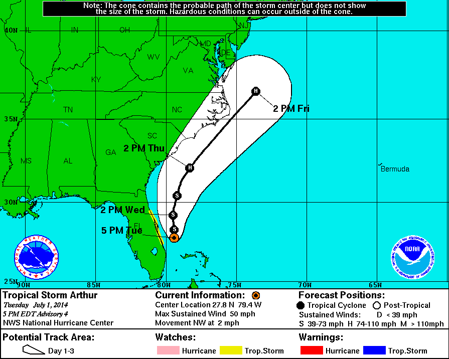
5 PM Update | Tropical Storm Arthur Strengthening
Tropical Storm Arthur is stronger than anticipated at this hour. Air Force Reserve recon flight recorded maximum sustained winds of 50 mph with a minimum low pressure of 1003 mb. Real time recon data showed some readings as sub-1000 mb with near hurricane force winds, but we will defer to the experts at NHC and stay with the official numbers for now. Tropical Storm Arthur’s TS force winds are extended outward 70 miles from the center of circulation which is presently located approximately 85 miles east-southeast of Cape Canaveral. Gusts on Grand Bahama Island have reached 51 mph. The forecast cone has narrowed and is no longer brushing the east coast of Florida.
The Air Force Reserve Hurricane Hunters and NOAA are both still collecting data in the region. NHC forecast shows Arthur strengthening into a hurricane on Wednesday.
Although TS Arthur is strengthening, the tropical storm watch is unchanged and remains in effect for the east coast of Florida from Fort Pierce north to Flagler Beach. This TS Storm watch does include Port Canaveral. Port Canaveral is open for business as usual per their automated telephone system.
Rain is expected to be in the range of 1-3 inches in eastern Florida with isolated areas receiving up to 5 inches.
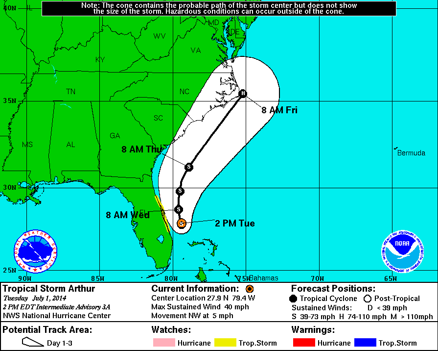
2 PM Intermediate Update | Tropical Storm Arthur Becoming Better Organized
Tropical Storm Arthur is gradually becoming better organized this afternoon, and is now moving northwest at 5 mph. Presently, the system is located about 80 miles east-southeast of Cape Canaveral, Florida. Maximum sustained winds remain at 40 mph with a reported gust of 44 mph on Grand Bahama Island. The pressure is holding at 1007 mb. The forecast track remains the same as the 11 AM update.
The Air Force Reserve Hurricane Hunters’ afternoon flight is in progress and should be within range of Tropical Storm Arthur in about an hour to provide real time observational data for the 5 PM update.
The tropical storm watch is unchanged and remains in effect for the east coast of Florida from Fort Pierce north to Flagler Beach. This TS Storm watch does include Port Canaveral. Tropical storm conditions are possible within the watch are by the end of the day on Tuesday. Port Canaveral is open for business as usual per their automated telephone system.
11 AM Update | Tropical Depression One Intensifies into Tropical Storm Arthur
Tropical Depression One is now Tropical Storm Arthur. Over the last 3 hours, the system has intensified into a tropical storm and is now moving towards the northwest at 2 mph. Presently, the system is still located about 95 miles southeast of Cape Canaveral, Florida. The winds have picked up to 40 mph while the pressure is holding at 1007 mb. 48 mph gusts have been recorded on Grand Bahama Island.
The forecast track suggests TS Arthur will continue on the current heading through tonight, then turn toward the north. The system is expected to remain offshore an move east of the east-central coast of Florida during the next 24 hours and pass was of northeastern Florida by Wednesday night. NHC does mention that the forecast track remains the same as earlier, but this could change depending on how the TS moves this afternoon.
The tropical storm watch is unchanged and remains in effect for the east coast of Florida from Fort Pierce north to Flagler Beach. This TS Storm watch does include Port Canaveral. Tropical storm conditions are possible within the watch are by the end of the day on Tuesday. Port Canaveral is open for business as usual per their automated telephone system.
8 AM Intermediate Update | Tropical Depression One Stationary Off Central Florida Coast
Tropical Depression One Expected to Develop into Tropical Storm Arthur
Over the last three hours, Tropical Depression One’s forward motion has decreased and is now sitting stationary about 95 miles southeast of Cape Canaveral, Florida. TD One continues to produce maximum sustained winds of 35 mph with a pressure of 1007 mb. There has been little change in organization over the early morning hours.
The system is still expected to move to the northwest later today followed by a turn to the north on Wednesday. Observations from Grand Bahama Island have reported sustained winds of 37 mph with gusts up to 43 mph.
The tropical storm watch issued late last night remains in effect for the east coast of Florida from Fort Pierce north to Flagler Beach. This TS Storm watch does include Port Canaveral. Tropical storm conditions are possible within the watch are by the end of the day on Tuesday. I called the port and at this time Port Canaveral is open for business as usual.
July 1, 2014
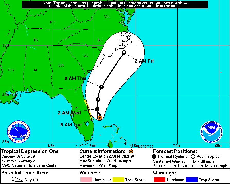
5 AM Update | Tropical Depression One Likely to Develop into Tropical Storm Arthur Today
Overnight Tropical Depression One has shifted a little to the west and is presently located 95 miles southeast of Cape Canaveral, Florida. TD One continues to produce maximum sustained winds of 35 mph and is moving west at 2 mph with a pressure of 1008 mb. There has been little change in organization over the early morning hours.
The tropical storm watch issued late last night remains in effect for the east coast of Florida from Fort Pierce north to Flagler Beach. This TS Storm watch does include Port Canaveral. Tropical storm conditions are possible within the watch are by the end of the day on Tuesday. I called the port and at this time Port Canaveral is open for business as usual.
The environmental conditions in the area are favorable for intensification as the system is expected to make a turn the northeast. The future forecast suggests the system will intensify into a tropical storm later today off the East Coast of Florida. The official forecast from the National Hurricane Center show further intensification to hurricane strength as its tracks towards the east coast of North Carolina.
The system is expected to bring rain across east-central and northeastern portions of Florida from 1-3 inches to isolated areas with 5 inches of liquid sunshine. The Bahamas are expected to see rainfall amounts in the 2-4 inch range with up to 6 inches in isolated areas.
Tropical Depression One – Spaghetti Models

Current GOES-Floater Visible Satellite Image

GOES – Tropical Cyclone Arthur Visible Satellite Loop
Tropical Cyclone History
This table contains the NHC’s statistics for the tropical cyclone from each advisory.
| Date | Time (EST) | Classification | Max Winds (mph) | Movement/Speed | Pressure (mb) |
| June 28 | — | Invest 91L | |||
| June 30 | 11 PM | Tropical Depression | 35 | SW at 2 mph | 1009 |
| July 1 | 2 AM | 35 | SW at 2 mph | 1009 | |
| 5 AM | 35 | W at 2 mph | 1008 | ||
| 8 AM | 35 | Stationary | 1007 | ||
| 11 AM | Tropical Storm | 40 | NW at 2 mph | 1007 | |
| 2 PM | 40 | NW at 5 mph | 1007 | ||
| 5 PM | 50 | NW at 2 mph | 1003 | ||
| 8 PM | 50 | Stationary | 1003 | ||
| 11 PM | 50 | N at 2 mph | 1003 | ||



Looks like it’s going to be out of the Dreams way before it comes home Thursday. Maybe the people on board will at least get one good day at sea before they head back. It looked like pretty much a washout for them today at CastAway Cay.