
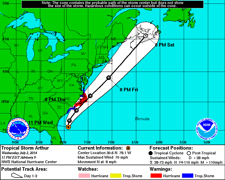
11 PM Update | Tropical Storm Arthur Pressure Continues to Drop
Tropical Storm Arthur continues to strengthen, but is still not at hurricane strength. Arthur is producing maximum sustained winds of 70 mph with a central pressure dropping to 988 mb. Tropical storm force winds have expanded to 90 miles from the center. TS Arthur is now located 380 miles southwest of Cape Hatteras, North Carolina and moving north at 8 mph.
Tropical Storm Arthur is expected to become the first hurricane of the 2014 season tomorrow.
There are no changes to the tropical storm warning, hurricane warning, or the hurricane watch that were updated at 5 PM. There is a mandatory evacuation order in place for Hatteras Island according to the Dare County, North Carolina’s website.
The Dare County Control Group has issued a mandatory evacuation order for residents and visitors on Hatteras Island beginning at 5:00 a.m., Thursday, July 3, 2014. After 5:00 a.m. Thursday, no access will be allowed to Hatteras Island.
Current Watches & Warnings
Hurricane Warning is in effect (below in red):
- Surf City north to Duck
- Eastern Albemarle Sound
- Pamlico Sound
Hurricane Watch is in effect (below in pink):
- Little River Inlet to South Surf City
Tropical Storm Warning is in effect (below in blue):
- South Santee River, South Carolina to south of Surf City, North Carolina
- North of Duck, North Carolina to Cape Charles Light, Virginia (not include Chesapeake Bay)
- Western Albemarle Sound
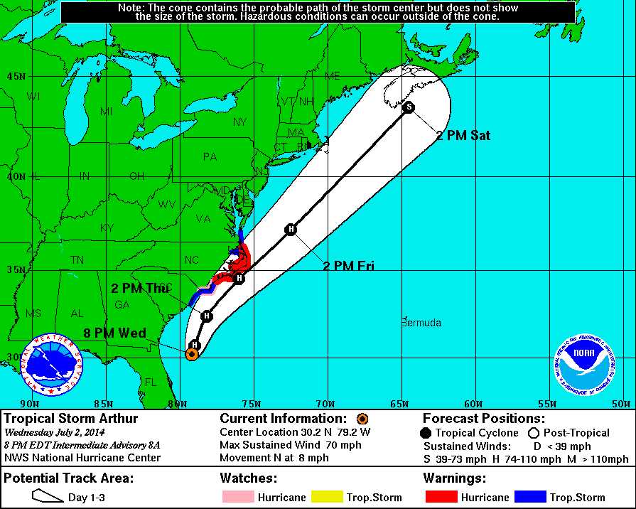
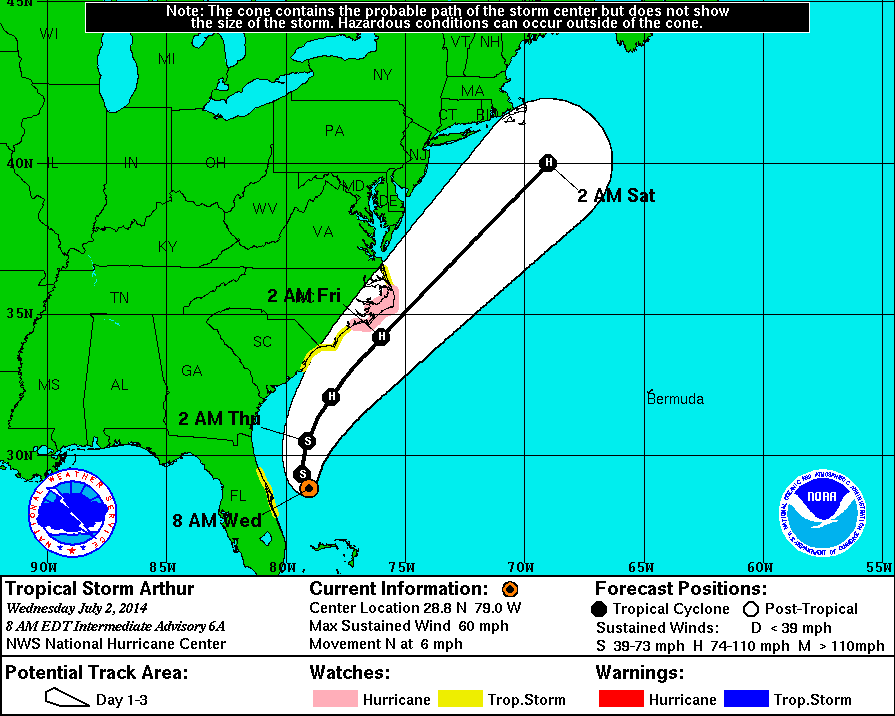
8 PM Intermediate Update | Tropical Storm Arthur Just Below Hurricane Strength
Tropical Storm Arthur continues to strengthen, and is just below hurricane strength with maximum sustained winds of 70 mph and a central pressure dropping to 990 mb. Tropical storm force winds continue to extend 80 miles from the center. TS Arthur is now located 405 miles south-southwest of Cape Hatteras, North Carolina and moving north at 8 mph.
Tropical Storm Arthur is expected to strengthen into a hurricane either later tonight or tomorrow as he changes course to the northeast with an increase in forward speed.
There are no changes to the tropical storm warning, hurricane warning, or the hurricane watch that were updated at 5 PM. There is a mandatory evacuation order in place for Hatteras Island according to the Dare County, North Carolina’s website.
The Dare County Control Group has issued a mandatory evacuation order for residents and visitors on Hatteras Island beginning at 5:00 a.m., Thursday, July 3, 2014. After 5:00 a.m. Thursday, no access will be allowed to Hatteras Island.
Current Watches & Warnings
Hurricane Warning is in effect (below in red):
- Surf City north to Duck
- Eastern Albemarle Sound
- Pamlico Sound
Hurricane Watch is in effect (below in pink):
- Little River Inlet to South Surf City
Tropical Storm Warning is in effect (below in blue):
- South Santee River, South Carolina to south of Surf City, North Carolina
- North of Duck, North Carolina to Cape Charles Light, Virginia (not include Chesapeake Bay)
- Western Albemarle Sound
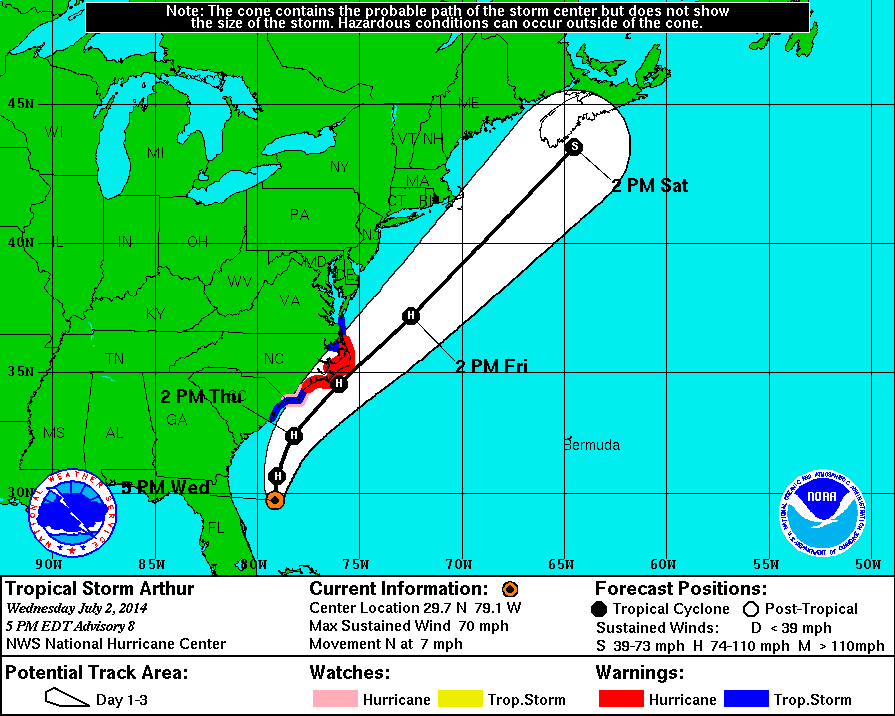
5 PM Update | Tropical Storm Arthur Nearing Hurricane Strength
Tropical Storm Arthur is strengthening, and is near hurricane strength this evening with maximum sustained winds of 70 mph and a central pressure remains at 992 mb. Tropical storm force winds continue to extend 80 miles from the center. TS Arthur is located 435 miles south-southwest of Cape Hatteras, North Carolina and moving north at 7 mph.
Tropical Storm Arthur is expected to strengthen into a hurricane either tonight or tomorrow and change course to the northeast with an increase in forward speed.
There are some changes to the watches and warnings at this hour. A hurricane warning has been issued for the North Carolina coast from Surf City north to Duck including Pamlico and Eastern Albemarle Sounds. A tropical storm warning has been issued from South Santee River, South Carolina to south of Surf City, North Carolina and from north of Duck, North Carolina to Cape Charles Light, Virginia and for Western Albemarle Sound. This does not include Chesapeake Bay. A hurricane watch has been issued in North Carolina from Little River Inlet to South Surf City.
Current Watches & Warnings
Hurricane Warning is in effect (below in red):
- Surf City north to Duck
- Eastern Albemarle Sound
- Pamlico Sound
Hurricane Watch is in effect (below in pink):
- Little River Inlet to South Surf City
Tropical Storm Warning is in effect (below in blue):
- South Santee River, South Carolina to south of Surf City, North Carolina
- North of Duck, North Carolina to Cape Charles Light, Virginia (not include Chesapeake Bay)
- Western Albemarle Sound
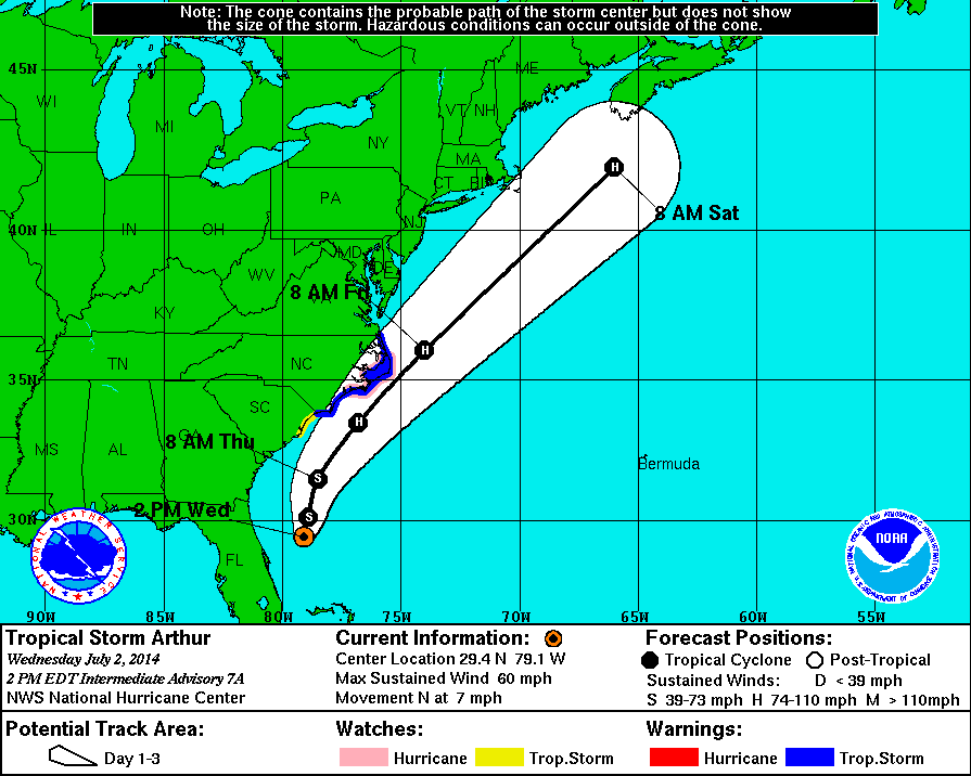
2 PM Intermediate Update | Tropical Storm Arthur Expected to Move Well East of North Coast Florida Tonight
Tropical Storm Arthur’s minimum central pressure remains at 997 mb with winds holding at 60 mph. Tropical storm force winds continue to extend 80 miles from the center. TS Arthur is located 110 miles east-northeast of Cape Canaveral, Florida moving north at 7 mph.
A USAF recon flight is in progress to gather some real time data for the 5 PM update.
There are no changes so far this afternoon to the tropical storm watch, tropical storm warning, and the hurricane watch.
Current Watches & Warnings
Tropical Storm Warning is in effect (below in blue):
- Little River Inlet, North Carolina to the North Carolina/Virginia boarder
- Eastern Albemarle Sound
- Pamlico Sound
Hurricane Watch is in effect (below in pink):
- Bogue Inlet to Oregon Inlet, North Carolina
- Pamlico Sound
Tropical Storm Watch is in effect (below in yellow):
- South of Little River Inlet, North Carolina to South Santee River, South Carolina
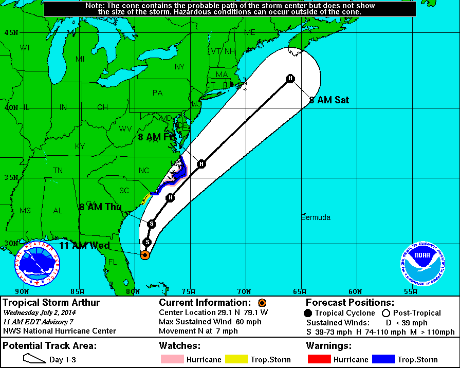
11 AM Update | Tropical Storm Watch Discontinued for East Coast of Florida – TS Warning Issued For North Carolina Coast
Tropical Storm Arthur’s minimum central pressure was recorded by both recon flights at 997 mb with winds holding at 60 mph with tropical storm force winds reaching 80 miles. Presently, Arthur is located 105 miles east-northeast of Cape Canaveral, Florida moving north at 7 mph.
Arthur is expected to continue north today before making a turn toward the north-northeast tonight. On Thursday, Arthur appears to pick up forward speed on a northeast heading. The timeline has been moved up and Arthur could potentially reach hurricane strength by Thursday.
The tropical storm warning which has been in effect for the east coast of Florida has been discontinued. However, a new tropical storm watch has been issued from Little River Inlet, North Carolina to the North Carolina/Virginia boarder.
Current Watches & Warnings
Tropical Storm Warning is in effect (below in blue):
- Little River Inlet, North Carolina to the North Carolina/Virginia boarder
- Eastern Albemarle Sound
- Pamlico Sound
Hurricane Watch is in effect (below in pink):
- Bogue Inlet to Oregon Inlet, North Carolina
- Pamlico Sound
Tropical Storm Watch is in effect (below in yellow):
- South of Little River Inlet, North Carolina to South Santee River, South Carolina
8 AM Intermediate Update | Hurricane Hunters and NOAA Planes Closely Monitoring TS Arthur
Tropical Storm Arthur’s minimum central pressure increased slightly over the last 3 hours to 998 mb. Arthur is presently located 100 miles east-northeast of Cape Canaveral, Florida moving north at 6 mph. Maximum sustained winds remain near 60 mph with TS force winds extending out 80 miles. A NOAA bout located just east of Arthur’s center recorded winds of 47 mph with a gust of 63 mph.
The spaghetti models are in agreement with the official track from NHC shown in the graphic below. Arthur is expected to continue north today before making a turn toward the north-northeast tonight. On Thursday, TS Arthur appears to pick up forward speed on a northeast heading and potentially reach hurricane strength Friday morning.
Current Watches & Warnings
Hurricane Watch is in effect (below in pink):
- Bogue Inlet to Oregon Inlet, North Carolina
- Pamlico Sound
Tropical Storm Watch is in effect (below in yellow):
- East Coast of Florida from Sebastian Inlet to Flagler Beach
- South Santee River, South Carolina to South of Bouge Inlet, North Carolina
- North of Oregon Inlet, North Carolina to North Carolina/Virginia boarder
- Eastern Albemarle Sound
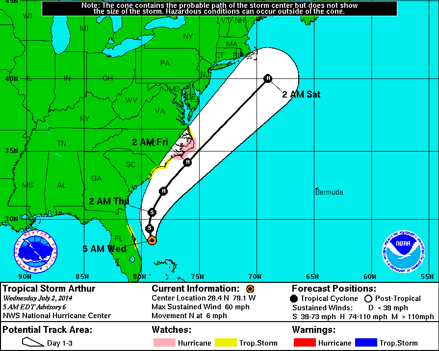
5 AM Update | Hurricane Watch issued for Part of North Carolina Coast

Tropical Storm Arthur’s minimum central pressure continues to drop and is now sub-1000 mb at 996 mb a sure sign of strengthening. Arthur is presently located 90 miles east of Cape Canaveral, Florida and is moving north at 6 mph. Maximum sustained winds are clocking 60 mph with a reach of 80 miles.
The tropical storm watch (yellow in the the graphic below) in Florida has been adjusted along the east coast and is now in effect from Sebastian Inlet north to Flagler Beach. The TS watch includes includes Port Canaveral but as of now is still open for business as usual.
A new tropical storm watch (yellow in the the graphic below) has been issued from South Santee River in South Carolina north to Bough Inlet, North Carolina as well as from Oregon Inlet, North Carolina to the Virginia boarder.
A new hurricane watch (pink in the the graphic below) is in effect from Bouge Inlet, North Carolina to Oregon Inlet, North Carolina.
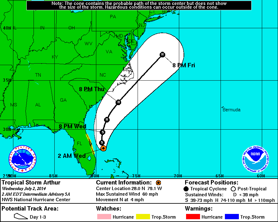
2 AM Intermediate Update | Tropical Storm Arthur Stronger as he Moves North

Tropical Storm Arthur’s forward motion north has picked up to 4 mph and is now about 95 miles east-southeast of Cape Canaveral, Florida. TS Arthur is becoming stronger with pressure dropping to 1001 mb. Arthur is producing maximum sustained winds of 60 mph tropical storm force winds extending outward 70 miles.
There are no changes to the tropical storm watch which remains in effect along the east coast of Florida from Fort Pierce to Flagler Beach. The TS watch includes includes Port Canaveral but as of now is still open for business as usual.
Tropical Cyclone History
This table contains the NHC’s statistics for the tropical cyclone from each advisory.
| Date | Time (EST) | Classification | Max Winds (mph) | Movement/Speed | Pressure (mb) |
| June 28 | — | Invest 91L | |||
| June 30 | 11 PM | Tropical Depression | 35 | SW at 2 mph | 1009 |
| July 1 | 2 AM | 35 | SW at 2 mph | 1009 | |
| 5 AM | 35 | W at 2 mph | 1008 | ||
| 8 AM | 35 | Stationary | 1007 | ||
| 11 AM | Tropical Storm | 40 | NW at 2 mph | 1007 | |
| 2 PM | 40 | NW at 5 mph | 1007 | ||
| 5 PM | 50 | NW at 2 mph | 1003 | ||
| 8 PM | 50 | Stationary | 1003 | ||
| 11 PM | 50 | N at 2 mph | 1003 | ||
| July 2 | 2 AM | 60 | N at 4 mph | 1001 | |
| 5 AM | 60 | N at 6 mph | 996 | ||
| 8 AM | 60 | N at 6 mph | 998 | ||
| 11 AM | 60 | N at 7 mph | 997 | ||
| 2 PM | 60 | N at 7 mph | 997 | ||
| 5 PM | 70 | N at 7 mph | 992 | ||
| 8 PM | 70 | N at 8 mph | 990 | ||
| 11 PM | 70 | N at 8 mph | 988 | ||