
11:30 PM Update | Hurricane Arthur makes Landfall
The eye of Hurricane Arthur made landfall over the Shackleford Banks between Cape Lookout and Beaufort, North Carolina. The NOAA weather station at Cape Lookout recorded winds of 77 mph and a gust of 101 mph. Arthur overall is producing 100 mph winds and is moving northeast at 18 mph.
The eye of #Arthur is approx 30 miles wide pic.twitter.com/NqOtR4uj14
— Scott Sanders (@TheDCLBlog) July 4, 2014
9 PM Update | Arthur Strengthens to Category 2 Hurricane
The eye of Hurricane Arthur is nearing the coast of North Carolina approximately 35 miles south of Cape Fear and is moving north-northeast at 13 mph. Arthur is producing maximum sustained winds of 90 mph with higher gusts. The recon flights recorded a minimum central pressure of 976 mb with hurricane force winds extending outward 35 miles and tropical storm force winds field out to 150 miles from the center.
There are changes to the watches and warnings currently in effect. The hurricane watch has been discontinued south of Surf City to Little River Inlet. The tropical storm warning has been discontinued south of Little River Inlet.
Current Watches & Warnings
Hurricane Warning is in effect (below in red):
- Surf City, NC to North Carolina/Virginia border
- Eastern Albemarle Sound
- Pamlico Sound
Tropical Storm Warning is in effect (below in blue):
- Little River Inlet to south of Surf City, North Carolina
- The North Carolina/Virginia border to Cape Charles Light, Virginia including the mouth of the Chesapeake Bay
- Western Albemarle Sound
- Nantucket
- Cape Code from Provincetown to Chatham
Tropical Storm Watch is in effect (below in yellow):
- Nova Scotia from Port Maitland to Point Aconi

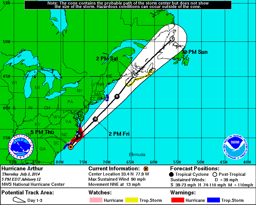
5 PM Update | Eye of Hurricane Arthur Nearing North Carolina Coast
The eye of Hurricane Arthur is nearing the coast of North Carolina approximately 35 miles south of Cape Fear and is moving north-northeast at 13 mph. Arthur is producing maximum sustained winds of 90 mph with higher gusts. The recon flights recorded a minimum central pressure of 980 mb and have determined that hurricane force winds expanded outward to 35 miles while tropical storm force winds field has expanded to 150 miles from the center.
For the most part, the models in agreement on the track up the east coast. NHC expects Arthur to strengthen into a category 2 hurricane by the time he passes near or over the North Carolina coast. A gradual weakening is expected to begin on Friday and is expected to become a post-tropical cyclone on Saturday.
There are changes to the tropical storm warning, hurricane warning, or the hurricane watch currently in effect. A tropical storm warning has been issued fro Nantucket island and for Cape Code from Provincetown to Chatham. Canada has issued a tropical storm watch for Nova Scotia from Port Maitland east and northward to Point Aconi.
Current Watches & Warnings
Hurricane Warning is in effect (below in red):
- Surf City north to North Carolina/Virginia border
- Eastern Albemarle Sound
- Pamlico Sound
Hurricane Watch is in effect (below in pink):
- Little River Inlet to South Surf City
Tropical Storm Warning is in effect (below in blue):
- South Santee River, South Carolina to south of Surf City, North Carolina
- The North Carolina/Virginia border to Cape Charles Light, Virginia including the mouth of the Chesapeake Bay
- Western Albemarle Sound
- Nantucket
- Cape Code from Provincetown to Chatham
Tropical Storm Watch is in effect (below in yellow):
- Nova Scotia from Port Maitland to Point Aconi
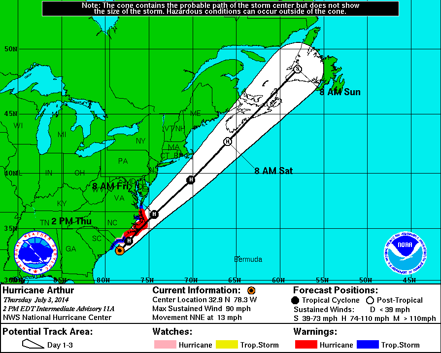
2 PM Intermediate Update | Hurricane Arthur Continues to Strengthen with TS Wind Reach Expanding
Hurricane Arthur causing conditions to deteriorate along the coast of North Carolina. Arthur is producing maximum sustained winds of 90 mph with higher gusts. The recon flights recorded a minimum central pressure of 980 mb and have determined that hurricane force winds extend outward 25 miles while tropical storm force winds field has expanded to 115 miles from the center. Hurricane Arthur is now located 70 miles south-southwest of Cape Fear, North Carolina and is moving north-northeast at 13 mph.
There are no changes to the tropical storm warning, hurricane warning, or the hurricane watch currently in effect. There is a mandatory evacuation order in place for Hatteras Island according to the Dare County, North Carolina’s website.
The Dare County Control Group has issued a mandatory evacuation order for residents and visitors on Hatteras Island beginning at 5:00 a.m., Thursday, July 3, 2014. After 5:00 a.m. Thursday, no access will be allowed to Hatteras Island.
Current Watches & Warnings
Hurricane Warning is in effect (below in red):
- Surf City north to North Carolina/Virginia border
- Eastern Albemarle Sound
- Pamlico Sound
Hurricane Watch is in effect (below in pink):
- Little River Inlet to South Surf City
Tropical Storm Warning is in effect (below in blue):
- South Santee River, South Carolina to south of Surf City, North Carolina
- The North Carolina/Virginia border to Cape Charles Light, Virginia including the mouth of the Chesapeake Bay
- Western Albemarle Sound
11 AM Update | Hurricane Arthur Continues to Strengthen with TS Wind Reach Expanding
Hurricane Arthur continues to strengthened this morning and the category 1 hurricane is now producing maximum sustained winds of 90 mph with higher gusts. The recon flights recorded a minimum central pressure of 981 mb and have determined that hurricane force winds extend outward 25 miles while tropical storm force winds field has expanded to 115 miles from the center. Hurricane Arthur is now located 260 miles southwest of Cape Hatteras, North Carolina and is moving north-northeast at 10 mph.
There are no changes to the tropical storm warning, hurricane warning, or the hurricane watch currently in effect. There is a mandatory evacuation order in place for Hatteras Island according to the Dare County, North Carolina’s website.
The Dare County Control Group has issued a mandatory evacuation order for residents and visitors on Hatteras Island beginning at 5:00 a.m., Thursday, July 3, 2014. After 5:00 a.m. Thursday, no access will be allowed to Hatteras Island.
Current Watches & Warnings
Hurricane Warning is in effect (below in red):
- Surf City north to North Carolina/Virginia border
- Eastern Albemarle Sound
- Pamlico Sound
Hurricane Watch is in effect (below in pink):
- Little River Inlet to South Surf City
Tropical Storm Warning is in effect (below in blue):
- South Santee River, South Carolina to south of Surf City, North Carolina
- The North Carolina/Virginia border to Cape Charles Light, Virginia including the mouth of the Chesapeake Bay
- Western Albemarle Sound
Today, Hurricane Arthur is expected to turn to the northeast and increase in forward speed. Arthur is forecast to continue to increase forward speed overnight and into Friday. The core of Hurricane Arthur is expected to approach the coast within the hurricane warning area tonight. Arthur is forecasted to reach category 2 status when it passes over or near the North Carolina coast before he begins to weaken Friday night and is expected to become post-tropical on Saturday.

8 AM Intermediate Update | Hurricane Arthur Continues to Strengthen
Hurricane Arthur continues to strengthened this morning and the category 1 hurricane is now producing maximum sustained winds of 80 mph with an recorded minimum central pressure of 983 mb. Hurricane force winds extend outward 25 miles while tropical storm force winds have a reach of 90 miles from the center. Hurricane Arthur is now located 300 miles southwest of Cape Hatteras, North Carolina and has changed it’s heading to the north-northeast moving at 9 mph.
There are no changes to the tropical storm warning, hurricane warning, or the hurricane watch currently in effect. There is a mandatory evacuation order in place for Hatteras Island according to the Dare County, North Carolina’s website.
The Dare County Control Group has issued a mandatory evacuation order for residents and visitors on Hatteras Island beginning at 5:00 a.m., Thursday, July 3, 2014. After 5:00 a.m. Thursday, no access will be allowed to Hatteras Island.
Current Watches & Warnings
Hurricane Warning is in effect (below in red):
- Surf City north to North Carolina/Virginia border
- Eastern Albemarle Sound
- Pamlico Sound
Hurricane Watch is in effect (below in pink):
- Little River Inlet to South Surf City
Tropical Storm Warning is in effect (below in blue):
- South Santee River, South Carolina to south of Surf City, North Carolina
- The North Carolina/Virginia border to Cape Charles Light, Virginia including the mouth of the Chesapeake Bay
- Western Albemarle Sound
Today, Hurricane Arthur is expected to turn to the northeast and increase in forward speed. Arthur is forecast to increase forward speed overnight and into Friday. The core of Hurricane Arthur is expected to approach the coast within the hurricane warning area tonight.
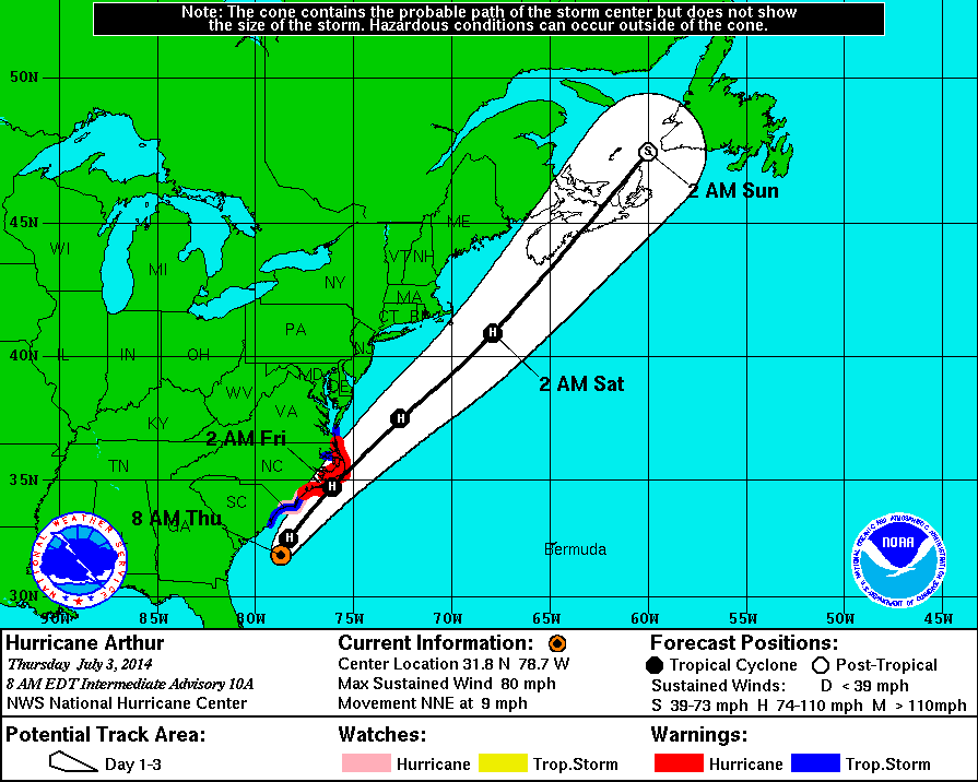
5 AM Update | Arthur Strengthens to a Hurricane
Tropical Storm Arthur has strengthened into the first hurricane of the season. Category 1 Hurricane Arthur is producing maximum sustained winds of 75 mph with an recorded minimum central pressure of 985 mb. Hurricane force winds extend outward 25 miles while tropical storm force winds have a reach of 90 miles from the center. Hurricane Arthur is now located 340 miles southwest of Cape Hatteras, North Carolina and moving north at 9 mph.
Hurricane Arthur is expected to move near the North Carolina Outer Banks later tonight.
There are some changes to the tropical storm warning, hurricane warning, or the hurricane watch that were issued on Tuesday afternoon. The hurricane warning has been extended northward from Duck, North Carolina to the North Carolina/Virginia border.
Additionally, there is a mandatory evacuation order in place for Hatteras Island according to the Dare County, North Carolina’s website.
The Dare County Control Group has issued a mandatory evacuation order for residents and visitors on Hatteras Island beginning at 5:00 a.m., Thursday, July 3, 2014. After 5:00 a.m. Thursday, no access will be allowed to Hatteras Island.
Current Watches & Warnings
Hurricane Warning is in effect (below in red):
- Surf City north to North Carolina/Virginia border
- Eastern Albemarle Sound
- Pamlico Sound
Hurricane Watch is in effect (below in pink):
- Little River Inlet to South Surf City
Tropical Storm Warning is in effect (below in blue):
- South Santee River, South Carolina to south of Surf City, North Carolina
- The North Carolina/Virginia border to Cape Charles Light, Virginia including the mouth of the Chesapeake Bay
- Western Albemarle Sound
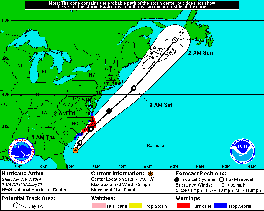
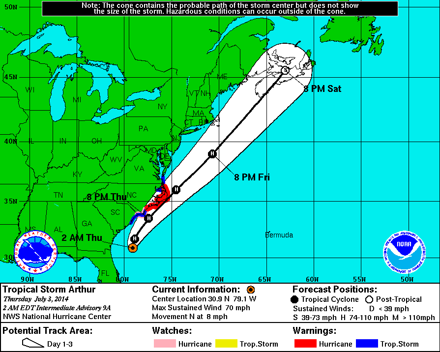
2 AM Intermediate Update | Tropical Storm Arthur Near Hurricane Strength

Tropical Storm Arthur continues to strengthen, but is still not at hurricane strength. Arthur is producing maximum sustained winds of 70 mph with an estimated minimum central pressure of 988 mb. Tropical storm force winds have expanded to 90 miles from the center. TS Arthur is now located 365 miles southwest of Cape Hatteras, North Carolina and moving north at 8 mph.
Tropical Storm Arthur is expected to become the first hurricane of the 2014 season tomorrow.
There are no changes to the tropical storm warning, hurricane warning, or the hurricane watch that were updated at 5 PM. There is amandatory evacuation order in place for Hatteras Island according to the Dare County, North Carolina’s website.
The Dare County Control Group has issued a mandatory evacuation order for residents and visitors on Hatteras Island beginning at 5:00 a.m., Thursday, July 3, 2014. After 5:00 a.m. Thursday, no access will be allowed to Hatteras Island.
Current Watches & Warnings
Hurricane Warning is in effect (below in red):
- Surf City north to Duck
- Eastern Albemarle Sound
- Pamlico Sound
Hurricane Watch is in effect (below in pink):
- Little River Inlet to South Surf City
Tropical Storm Warning is in effect (below in blue):
- South Santee River, South Carolina to south of Surf City, North Carolina
- North of Duck, North Carolina to Cape Charles Light, Virginia (not include Chesapeake Bay)
- Western Albemarle Sound
Tropical Cyclone History
This table contains the NHC’s statistics for the tropical cyclone from each advisory.
| Date | Time (EST) | Classification | Max Winds (mph) | Movement/Speed | Pressure (mb) |
| June 28 | — | Invest 91L | |||
| June 30 | 11 PM | Tropical Depression | 35 | SW at 2 mph | 1009 |
| July 1 | 2 AM | 35 | SW at 2 mph | 1009 | |
| 5 AM | 35 | W at 2 mph | 1008 | ||
| 8 AM | 35 | Stationary | 1007 | ||
| 11 AM | Tropical Storm | 40 | NW at 2 mph | 1007 | |
| 2 PM | 40 | NW at 5 mph | 1007 | ||
| 5 PM | 50 | NW at 2 mph | 1003 | ||
| 8 PM | 50 | Stationary | 1003 | ||
| 11 PM | 50 | N at 2 mph | 1003 | ||
| July 2 | 2 AM | 60 | N at 4 mph | 1001 | |
| 5 AM | 60 | N at 6 mph | 996 | ||
| 8 AM | 60 | N at 6 mph | 998 | ||
| 11 AM | 60 | N at 7 mph | 997 | ||
| 2 PM | 60 | N at 7 mph | 997 | ||
| 5 PM | 70 | N at 7 mph | 992 | ||
| 8 PM | 70 | N at 8 mph | 990 | ||
| 11 PM | 70 | N at 8 mph | 988 | ||
| July 3 | 2 AM | 70 | N at 8 mph | 988 | |
| 5 AM | Hurricane | 75 | N at 9 mph | 985 | |
| 8 AM | 80 | NNE at 9 mph | 983 | ||
| 11 AM | 90 | NNE at 10 mph | 981 | ||
| 2 PM | 90 | NNE at 13 mph | 980 | ||
| 5 PM | 90 | NNE at 13 mph | 977 | ||
| 7 PM | 90 | NNE at 15 mph | 977 | ||
| 8 PM | 90 | NNE at 15 mph | 997 | ||
| 9 PM | 100 | NNE at 15 mph | 976 | ||
| 11 PM | 100 | NE at 18 mph | 976 | ||