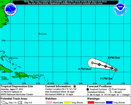
11 PM Update | Erin Weakens to a Tropical Depression… Again
Well, Erin seems like another one of those storms that is intent on hovering between classifications. Erin is now a tropical depression for the second time and should continue to weaken through Sunday. Monday, Erin should become a remnant low…
5 PM Update | Erin Barely Maintaining Tropical Storm Status
Tropical Storm Erin is moving northwest at 13 mph with max winds of 40 mph. The estimated minimum central pressure of 1006 mb. The latest forecast has Erin weakening to a tropical depression within 12 hours and fully dissipating by Tuesday.
11 PM Update | Erin Remains a Weak Tropical Storm
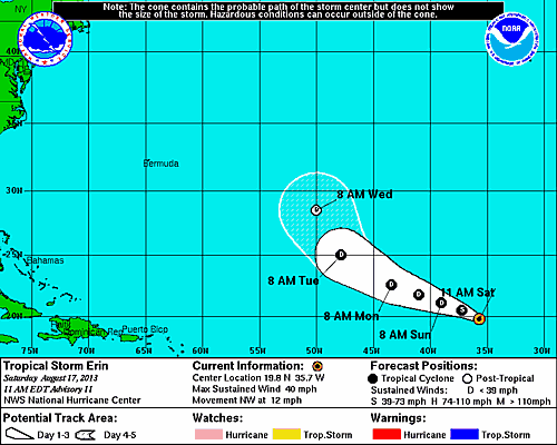
Tropical Storm Erin continues to hold her found this morning, barely… Erin has slowed and changed course, she is now moving to the northwest at 12 mph. Erin’s maximum sustained winds remain at 40 mph as does the estimated minimum central pressure of 1006 mb.
The notable change this morning is the NHC’s official track with is now more in tune with the global consensus near the end of the forecast period. Gradual weakening is expected to occur this weekend. The forecast now shows Tropical Storm Erin weakening to a remnant low in about 4 days and dissipating on Wednesday.
5 AM Update | Erin Remains a Tropical Storm
Tropical Storm Erin did not change much overnight. After a slight detour, Erin is again moving to the west-northwest at 15 mph with maximum sustained winds of 40 mph and pressure is holding at 1006 mb. It is notable, that tropical storm force winds are extending outward up to 70 miles from the center of circulation. TS Erin’s forward movement will begin to slow down in over the next couple of days. Erin is expected to maintain tropical storm status today and begin to weaken on Sunday.
The official forecast track has shifted to the north once again as models continue to show Tropical Storm Erin staying well away from land and cruise ships!
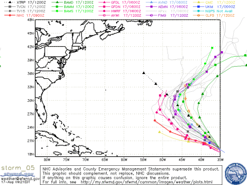
The official forecast from NHC show Erin weakening to a depression again in a few days and further to a remnant low in four days. However, the majority of the global models are suggesting that Erin will dissipate earlier than expected.
Current GOES-Floater Visible Satellite Image

Tropical Storm/Depression Erin | System History
This table contains the NHC’s statistics for the tropical cyclone from each advisory.
| Date | Time (EST) | Classification | Max Winds (mph) | Movement/Speed | Pressure (mb) |
| Aug 14 | 11 PM | Tropical Depression | 35 | WNW at 14 mph | 1008 |
| Aug 15 | 5 AM | 35 | WNW at 16 mph | 1007 | |
| 8 AM* | Tropical Storm | 40 | WNW at 16 mph | 1006 | |
| 11 AM | 40 | WNW at 15 mph | 1006 | ||
| 5 PM | 40 | WNW at 14 mph | 1006 | ||
| 11 PM | 40 | WNW at 15 mph | 1007 | ||
| Aug 16 | 5 AM | 40 | WNW at 16 mph | 1007 | |
| 11 AM | Tropical Depression | 35 | WNW at 17 mph | 1008 | |
| 5 PM | 35 | WNW at 17 mph | 1008 | ||
| 11 PM | Tropical Storm | 40 | NW at 15 mph | 1006 | |
| Aug 17 | 5 AM | 40 | WNW at 14 mph | 1006 | |
| 11 AM | 40 | NW at 12 mph | 1006 | ||
| 5 PM | 40 | NW at 13 mph | 1006 | ||
| 11 PM | Tropical Depression | 35 | WNW at 12 mph | 1008 |
Invest 92L | Gulf of Mexico
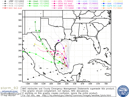
Elsewhere, we are continuing to monitor Invest 92L in the Gulf of Mexico near the Yucatan Peninsula. The National Hurricane Center has it as a 40% (medium) chance for development during the next couple days and a 50% (medium) chance over the next five days. The low pressure system remains poorly organized with thunderstorms located to the north and northeast of the low. Conditions could become more favorable for development over the next few days. Winds are currently estimated at 30 mph with a pressure of 1010 mb. The jet stream is dipping low into the Gulf of Mexico. As a result it looks to keep the Invest 92L headed to the the Gulf coast of Mexico and or Texas. Additionally, the jet stream is pulling moisture away from the low which is why there are strong thunderstorms to the north and northeast of the low.
The latest intensity forecasts do suggest hat Invest 92L could be at tropical storm strength in a couple days. The spaghetti models for Invest 92L are a little more in agreement today, although still a there is some uncertainty.


