
With the peak of hurricane season still ahead of us, the tropics are beginning to come alive. Just this past week we monitored a system in the Gulf of Mexico, that (thankfully) never amounted to anything serious, and we are finally winding down our discussion of Tropical Depression Erin. Now, we have an all new area to keep an eye on this week, Invest 94L. We mentioned a tropical wave has emerged off the coast of Africa. In a previous update we suggested that Erin may be paving the way for this next system, and as of this morning it’s being investigated by the NHC.
Invest 94L
The National Hurricane Center’s morning update a new area of interest, a tropical wave that has emerged off the coast of Africa. Invest 94L is now listed a a low chance (10%) for development over the next couple days, but that chance increases to 30% for tropical cyclone development over the next 5 days.
The afternoon update still has Invest 94L as a 10% chance for the next two days and has dropped the 5-day percentage to 20%.
UPDATE Monday 8/19/13 | NHC no longer has this area under investigation. Tropics are quiet.
Tropical Depression Erin
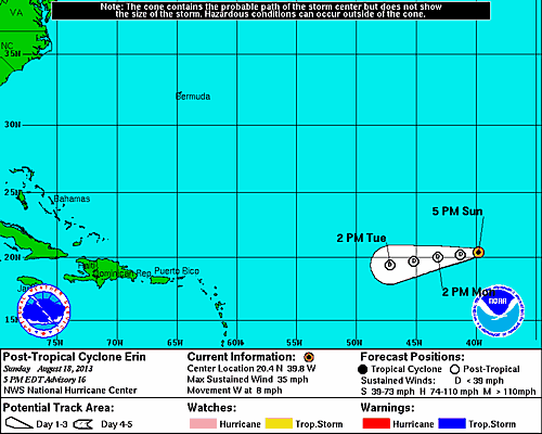
5 PM Update | Post-Tropical Cyclone | Erin Degenerates into Remnant Low (LAST UPDATE)
Tropical Depression Erin degenerated into a remnant low this afternoon. Erin should loser her identity early in the week. Unlike Dorian, Erin is moving into an area of dry air which will not be conducive for regeneration.
11 AM Update | Erin Continuing to Lose Steam
Tropical Depression Erin continues to loose momentum, and will soon be a remnant low according to the latest forecast from the National Hurricane Center. Erin is now moving west at 10 mph with maximum sustained winds of 35 mph.
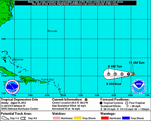
Satellite imagery continues to show a circulation, but is devoid of any convection. There is however, a patch of thunderstorms about 15o miles north of her center. The forecast discussion admits they are being generous with her current intensity. Erin is now on the clock and should be gone within the next 24 hours.
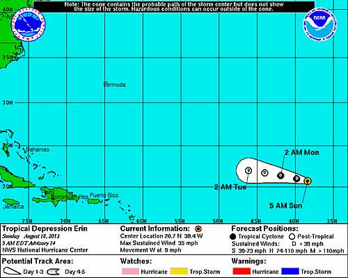
5 AM Update | Erin Loosing Steam
Tropical Depression Erin’s time is numbered. TD Erin movement is becoming slower and slower, now heading west at 9 mph. Here winds are estimated to be 35 mph and her pressure has increased to 1008 mb. The general track is expected to continue, but she will gradually be weakening to a remnant low on Monday. The visible satellite still shows circulation, but the storms are well to the north-northeast.
Tropical Storm/Depression Erin | System History
This table contains the NHC’s statistics for the tropical cyclone from each advisory.
| Date | Time (EST) | Classification | Max Winds (mph) | Movement/Speed | Pressure (mb) |
| Aug 14 | 11 PM | Tropical Depression | 35 | WNW at 14 mph | 1008 |
| Aug 15 | 5 AM | 35 | WNW at 16 mph | 1007 | |
| 8 AM* | Tropical Storm | 40 | WNW at 16 mph | 1006 | |
| 11 AM | 40 | WNW at 15 mph | 1006 | ||
| 5 PM | 40 | WNW at 14 mph | 1006 | ||
| 11 PM | 40 | WNW at 15 mph | 1007 | ||
| Aug 16 | 5 AM | 40 | WNW at 16 mph | 1007 | |
| 11 AM | Tropical Depression | 35 | WNW at 17 mph | 1008 | |
| 5 PM | 35 | WNW at 17 mph | 1008 | ||
| 11 PM | Tropical Storm | 40 | NW at 15 mph | 1006 | |
| Aug 17 | 5 AM | 40 | WNW at 14 mph | 1006 | |
| 11 AM | 40 | NW at 12 mph | 1006 | ||
| 5 PM | 40 | NW at 13 mph | 1006 | ||
| 11 PM | Tropical Depression | 35 | WNW at 12 mph | 1008 | |
| Aug 18 | 5 AM | 35 | W at 9 mph | 1008 | |
| 11 AM | 35 | W at 10 mph | 1008 | ||
| 5 PM | DEGENERATED REMNANT LOW | ||||