
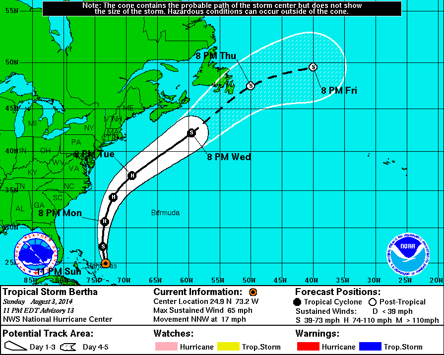
11 PM Update | Tropical Storm Bertha Quickly Strengthening
Bertha is now 190 east of Eleuthera Island and is rapidly strenghting. She is now moving north-northwest at 17 with maximum sustained winds jumping up to 65 mph with a reach of 160 from the center, primarily to the east. Pressure has also dropped to 1007 mb. Berta appears to be on track to reach hurricane status sooner than expected. but will likely remain in open waters.
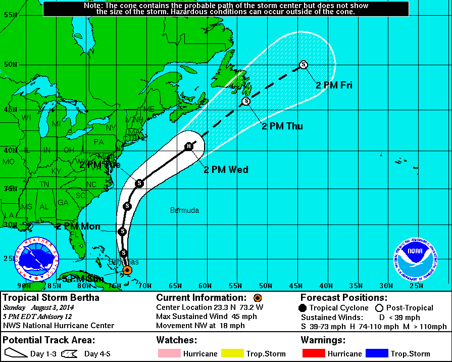
5 PM Update | Tropical Storm Bertha Moving Away From Southeastern Bahamas
The big news this hour is that all tropical storm watches and warnings have been discontinued!
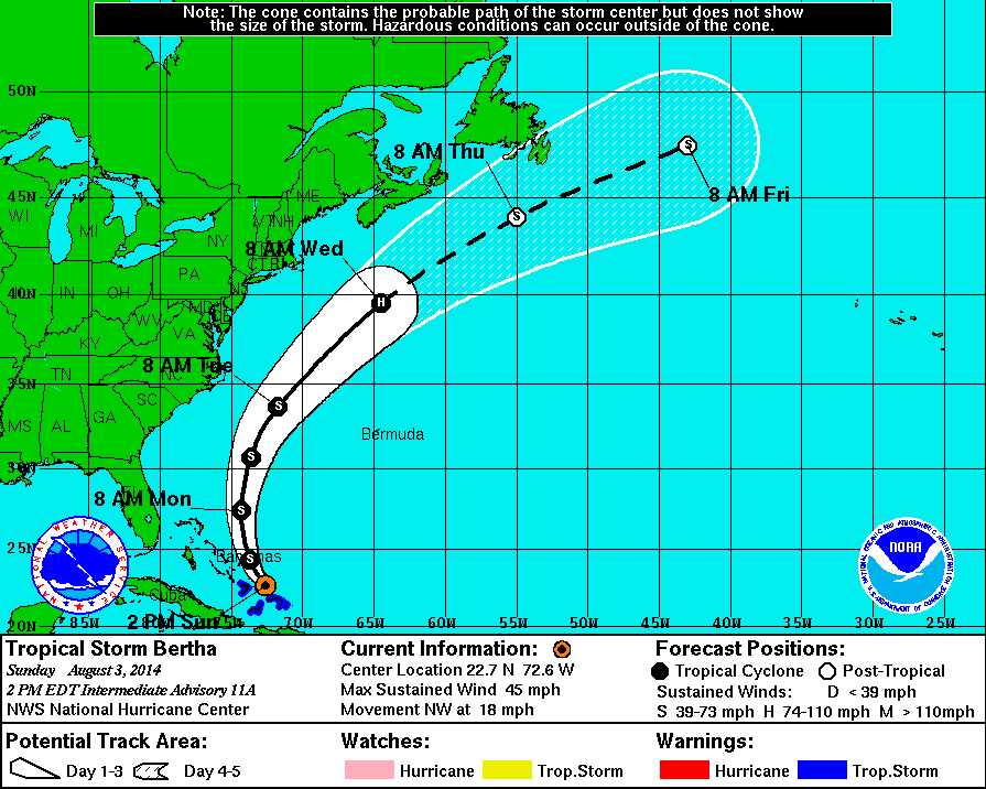
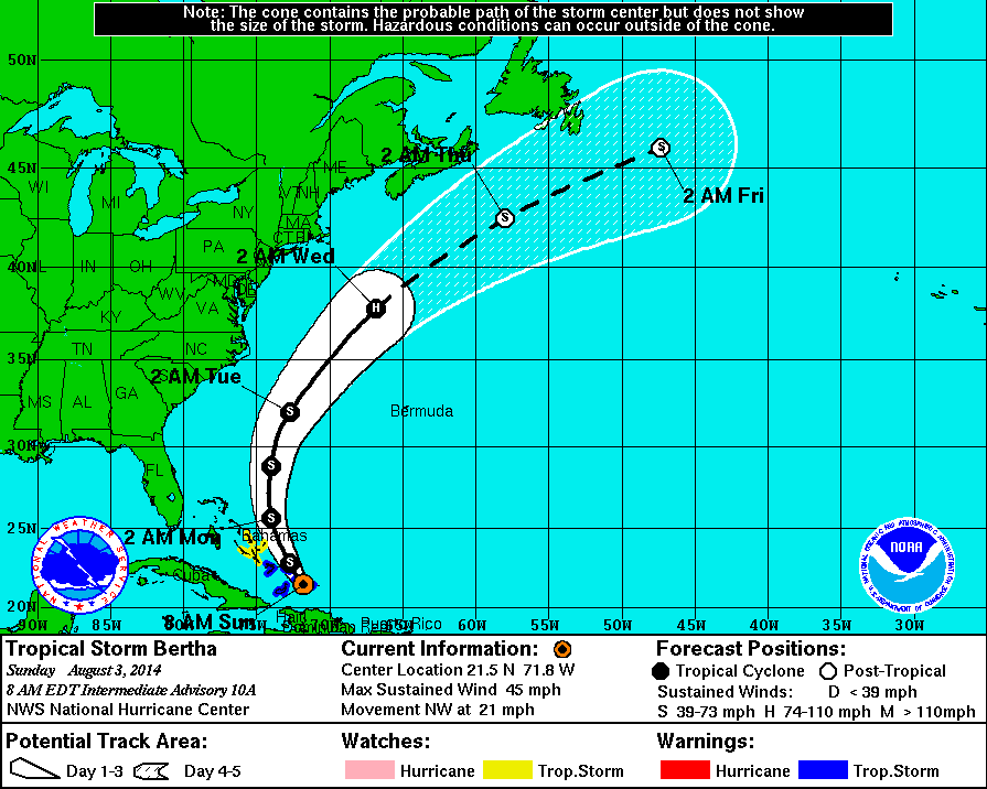
2 PM Intermediate Update | Tropical Storm Bertha Moving Near Southeastern Bahamas
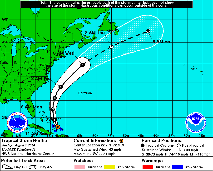
11 AM Update | Tropical Storm Bertha Moving Near Southeastern Bahamas
Tropical Storm Bertha is approximately 175 miles southeast of San Salvador moving northwest at 21 mph. Maximum sustained winds remain at 45 mph with TS force wind extending outward from the center, mostly to the northeast, 160 miles. The minimum central pressure is holding at 1012 mb.
The forecast expects TS Bertha to turn north-northwest then north overnight and early Monday morning where she will begin heading north-northeast. Bertha will begin moving away from Southeastern Bahamas, later today. The center is expected to pass to the east of the central Bahamas this evening.
Atmospheric conditions are becoming more favorable for the system. The intensity forecast continues to indicate strengthening will begin later today as she moves over open waters between the East Coast and Bermuda. Bertha may briefly reach hurricane strength on Wednesday with an estimated 75 mph winds as she is well away from land in the Atlantic ocean.
Heavy rain is still a threat in the Dominican Republic and the Turks and Caicos through Monday.
8 AM Intermediate Update | Tropical Storm Bertha Near Turks and Caicos
Tropical Storm Bertha is approximately 45 miles west of Grand Turk Island moving northwest at 21 mph. Maximum sustained winds remain at 45 mph with TS force wind extending outward from the center, mostly to the northeast, 160 miles. The minimum central pressure is holding at 1012 mb.
The forecast expects TS Bertha to continue to move on her current heading today and turn north-northwest then north overnight and early Monday morning. Bertha will move near the Southeastern Bahamas and Turks and Caicos this morning. Later today, TS Bertha will move east of the Central Bahamas eventually heading out to sea.
The intensity forecast continues to indicate strengthening will begin later today as she moves over open waters between the East Coast and Bermuda. Bertha may briefly reach hurricane strength on Wednesday with an estimated 75 mph winds as she is well away from land in the Atlantic ocean.
The tropical storm warning for the Dominican Republic has been discontinued. Although, heavy rain is still a threat in the Dominican Repubic.
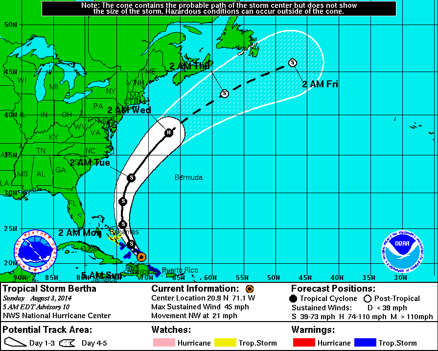
5 AM Update | Bertha Moving Away From the Dominican Republic Leaving Heavy Rain Behind
Tropical Storm Bertha is approximately 40 miles south of Grand Turk island moving northwest at 21 mph. Maximum sustained winds remain at 45 mph with TS force wind extending outward from the center, mostly to the northeast, 160 miles. The minimum central pressure is holding at 1012 mb.
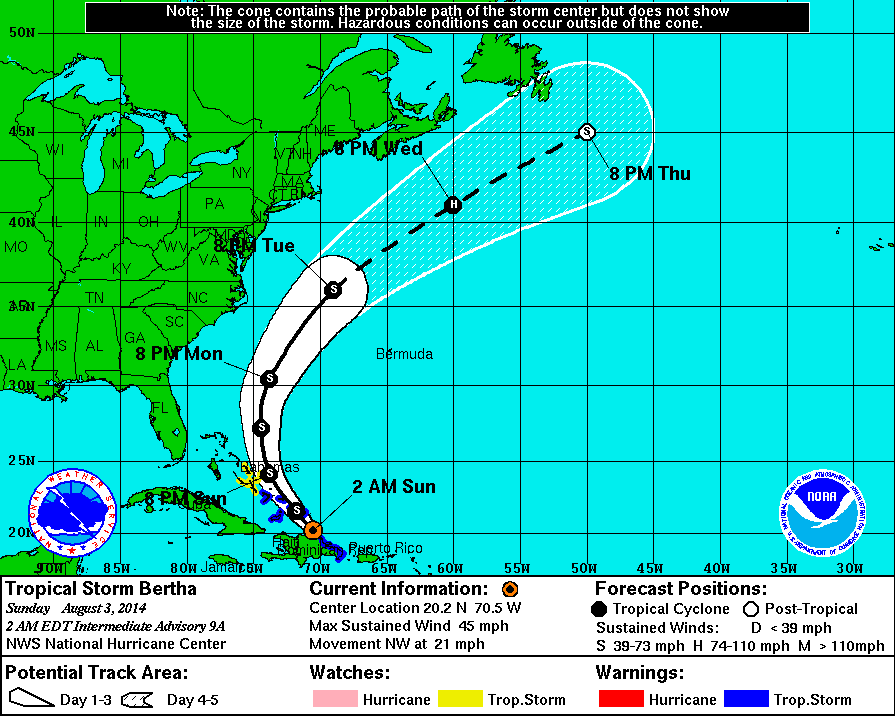
2 AM Intermediate Update | Tropical Storm Bertha Heading to The Southern Bahamas & Turks and Caicos
Tropical Storm Bertha is approximately 30 miles north of Puerto Plata, Dominican Republic moving northwest at 21 mph. Maximum sustained winds remain at 45 mph with TS force wind extending outward, mainly to the north and east the center to 160 miles. The minimum central pressure is up to 1012 mb.
Tropical Cyclone History | Bertha
This table contains the NHC’s statistics for the tropical cyclone from each advisory.
| Date | Time (EST) | Classification | Max Winds (mph) | Movement/Speed | Pressure (mb) |
| July 28 | Invest 93L | ||||
| July 29 | |||||
| July 30 | |||||
| July 31 | 11 PM | Tropical Storm | 45 | WNW at 20 mph | 1008 |
| Aug 1 | 2 AM | 45 | WNW at 18 mph | 1008 | |
| 5 AM | 45 | WNW at 20 mph | 1008 | ||
| 8 AM | 45 | WNW at 20 mph | 1008 | ||
| 11 AM | 50 | WNW at 21 mph | 1008 | ||
| 2 PM | 50 | WNW at 22 mph | 1007 | ||
| 5 PM | 50 | WNW at 24 mph | 1007 | ||
| 8 PM | 50 | WNW at 24 mph | 1007 | ||
| 11 PM | 50 | WNW at 22 mph | 1007 | ||
| Aug 2 | 2 AM | 50 | WNW at 22 mph | 1008 | |
| 5 AM | 50 | WNW at 22 mph | 1008 | ||
| 8 AM | 50 | WNW at 22 mph | 1008 | ||
| 11 AM | 50 | WNW at 22 mph | 1008 | ||
| 2 PM | 50 | WNW at 22 mph | 1009 | ||
| 5 PM | 45 | WNW at 22 mph | 1010 | ||
| 8 PM | 45 | WNW at 22 mph | 1010 | ||
| 11 PM | 45 | NW at 22 mph | 1010 | ||
| Aug 3 | 2 AM | 45 | NW at 21 mph | 1012 | |
| 5 AM | 45 | NW at 21 mph | 1012 | ||
| 8 AM | 45 | NW at 21 mph | 1012 | ||
| 11 AM | 45 | NW at 21 mph | 1012 | ||
| 2 PM | 45 | NW at 18 mph | 1012 | ||
| 5 PM | 45 | NW at 18 mph | 1012 | ||
| 8 PM | 65 | NNW at 17 mph | 1007 | ||
| 11 PM | 65 | NNW at 17 mph | 1007 | ||