
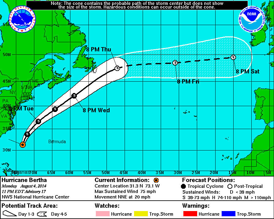
11 PM Update | Hurricane Bertha Expected to Weaken Tuesday
Hurricane Bertha is now approximately 490 miles west of Bermuda. She is moving north-northeast at 20 mph with maximum sustained winds of 75 mph. Hurricane force winds are extended outwards up to 25 miles while TS force winds are reaching out 125 miles. The estimated minimum central pressure is up to 1001 mb.
Bertha will pass about midway between the United States and Bermuda tomorrow and make a gradual turn to the northeast with increased forward speeed.
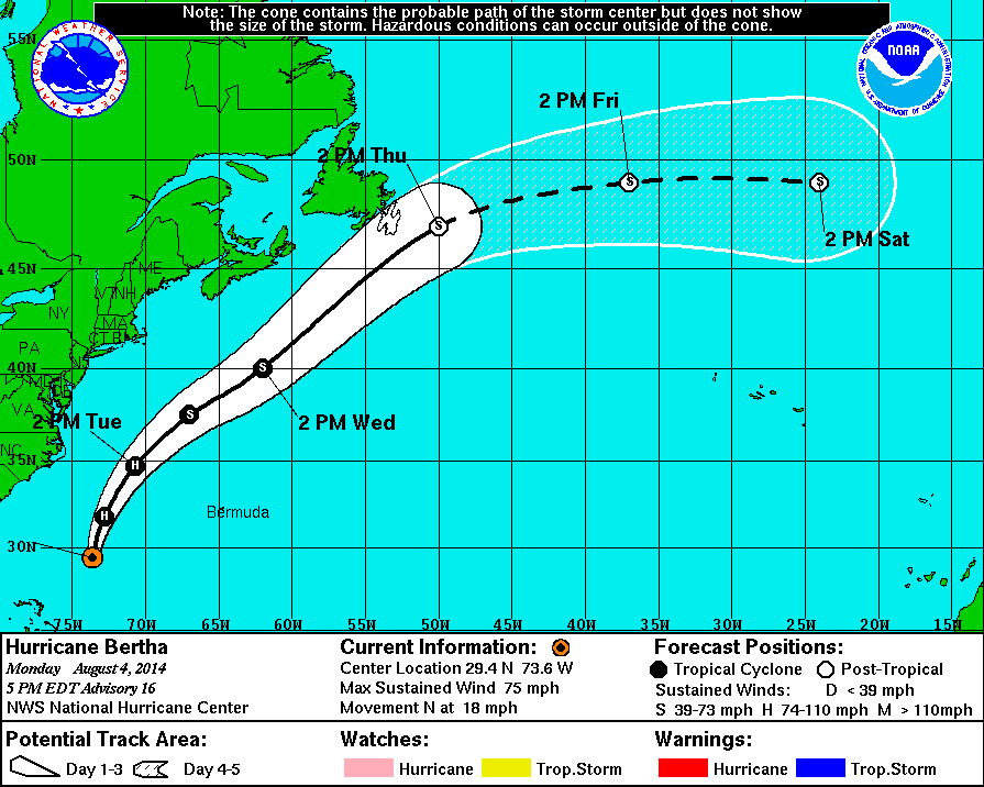
5 PM Update | Hurricane Bertha No Threat to Land as She Continues North
According to the National Hurricane Center, Hurricane Bertha is not a threat to land. Bertha is now approximately 560 miles west-southwest of Bermuda. She is moving north at 18 mph with maximum sustained winds dropping to 75 mph. Hurricane force winds are extended outwards up to 25 miles while TS force winds are reaching out 140 miles. The estimated minimum central pressure is 998 mb.
Bertha will pass about midway between the United States and Bermuda tomorrow and make a gradual turn to the northeast over the next two days.
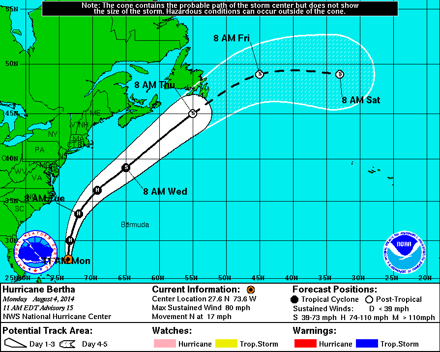
11 AM Update | Bertha Becomes 2nd Atlantic Hurricane of 2014
We now have Hurricane Bertha. Bertha has strengthened into the second hurricane of 2014 Atlantic season. She is now approximately 230 miles east-northeast of Great Abaco Island well away from Castaway Cay. She is moving north at 17 mph with maximum sustained winds increasing to 80 mph. Hurricane force winds are extended outwards up to 25 miles while TS force winds are reaching out 160 miles. The estimated minimum central pressure is 998 mb.
Little change is expected in strength during the next 24 hours as she will gain forward speed and move midway between the United States and Bermuda tomorrow.
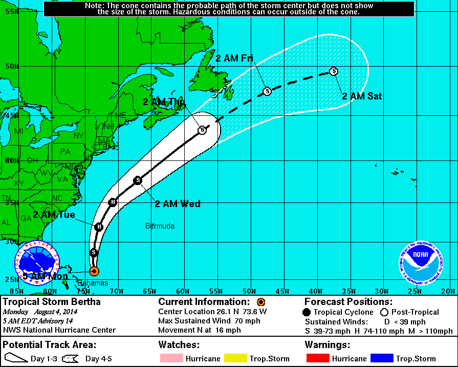
5 AM Update | Bertha Strengthens Overnight
Tropical Storm Bertha continues to strengthen and is now approximately 220 miles east of Great Abaco Island well away from Castaway Cay. She is moving north at 16 mph with maximum sustained winds increasing to 70 mph. TS force winds are extending outward from the center, 160 miles. The minimum central pressure dropped overnight to 999 mb.
TS Bertha is forecast to stay over open water passing midway between the United States an Bermuda on Tuesday. She could become a hurricane as early as today, followed by a gradual weakening as she moves further north.
Tropical Cyclone History | Bertha
This table contains the NHC’s statistics for the tropical cyclone from each advisory.
| Date | Time (EST) | Classification | Max Winds (mph) | Movement/Speed | Pressure (mb) |
| July 28 | Invest 93L | ||||
| July 29 | |||||
| July 30 | |||||
| July 31 | 11 PM | Tropical Storm | 45 | WNW at 20 mph | 1008 |
| Aug 1 | 2 AM | 45 | WNW at 18 mph | 1008 | |
| 5 AM | 45 | WNW at 20 mph | 1008 | ||
| 8 AM | 45 | WNW at 20 mph | 1008 | ||
| 11 AM | 50 | WNW at 21 mph | 1008 | ||
| 2 PM | 50 | WNW at 22 mph | 1007 | ||
| 5 PM | 50 | WNW at 24 mph | 1007 | ||
| 8 PM | 50 | WNW at 24 mph | 1007 | ||
| 11 PM | 50 | WNW at 22 mph | 1007 | ||
| Aug 2 | 2 AM | 50 | WNW at 22 mph | 1008 | |
| 5 AM | 50 | WNW at 22 mph | 1008 | ||
| 8 AM | 50 | WNW at 22 mph | 1008 | ||
| 11 AM | 50 | WNW at 22 mph | 1008 | ||
| 2 PM | 50 | WNW at 22 mph | 1009 | ||
| 5 PM | 45 | WNW at 22 mph | 1010 | ||
| 8 PM | 45 | WNW at 22 mph | 1010 | ||
| 11 PM | 45 | NW at 22 mph | 1010 | ||
| Aug 3 | 2 AM | 45 | NW at 21 mph | 1012 | |
| 5 AM | 45 | NW at 21 mph | 1012 | ||
| 8 AM | 45 | NW at 21 mph | 1012 | ||
| 11 AM | 45 | NW at 21 mph | 1012 | ||
| 2 PM | 45 | NW at 18 mph | 1012 | ||
| 5 PM | 45 | NW at 18 mph | 1012 | ||
| 8 PM | 65 | NNW at 17 mph | 1007 | ||
| 11 PM | 65 | NNW at 17 mph | 1007 | ||
| Aug 4 | 5 AM | 70 | N at 16 mph | 999 | |
| 11 AM | Hurricane | 80 | N at 17 mph | 998 | |
| 5 PM | 75 | N at 18 mph | 998 | ||
| 11 PM | 75 | NNE at 20 mph | 1001 | ||