
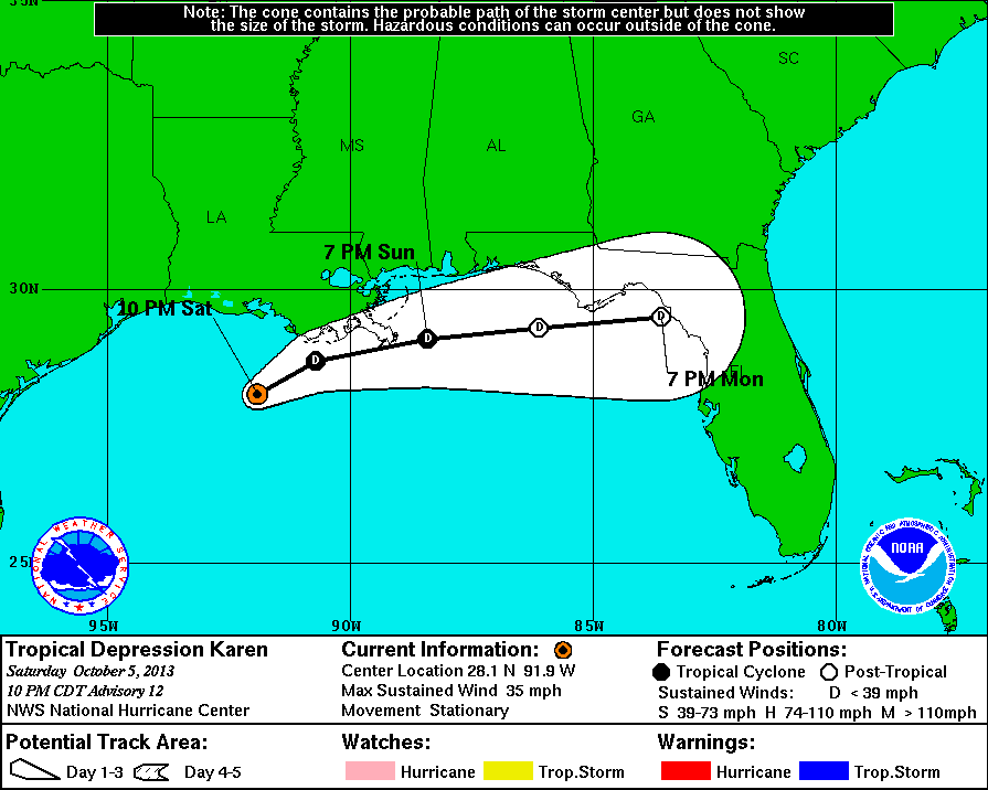
11 PM Update | Karen Weakens to a Tropical Depression
Tropical Storm Karen has been downgraded to a tropical depression and is sitting stationary at this hour with maximum sustained winds of 35 mph. Tropical depression Karen is located 120 miles south-southwest of Morgan City, Louisiana and is expected to turn to the northeast followed by a turn to the east-northeast on Sunday. The forecast suggests that Karen may degenerate into remnant low by Monday.
Watches & Warnings as of 11 PM
All tropical storm warnings have been discontinued. There are NO coastal tropical storm warnings or watches in effect.
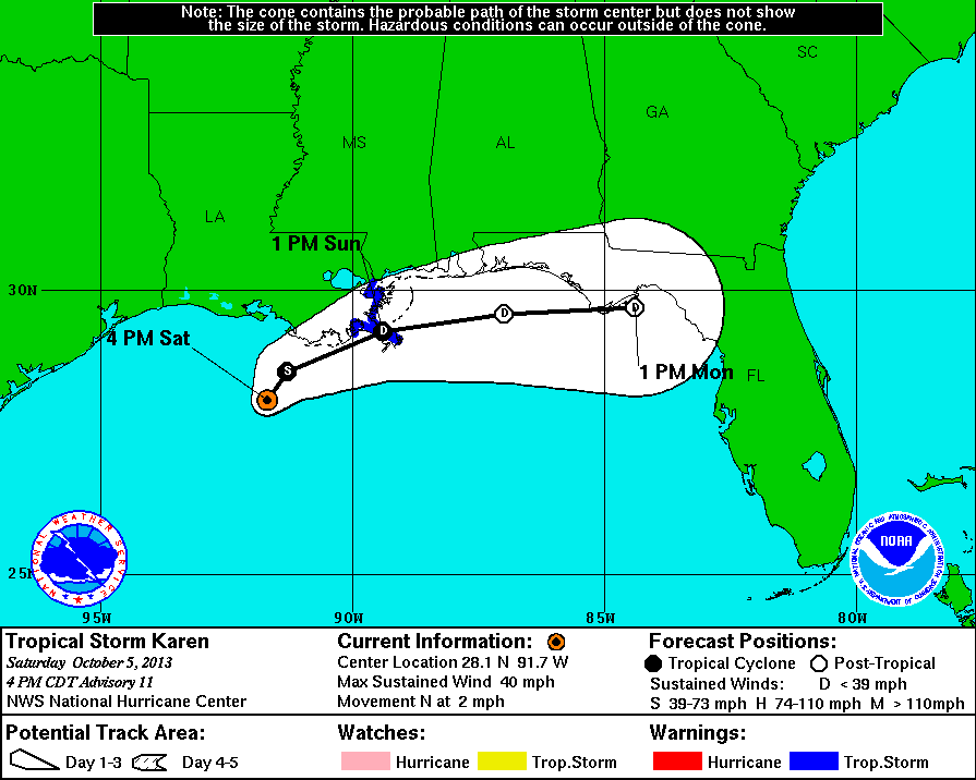
5 PM Update | All Tropical Storm Watches Discontinued
Tropical Storm Karen is now moving to the North at 2mph with maximum sustained winds of 40 mph. Karen is still a tropical storm, but her tropical storm force wind field has shrunk from over 100 miles earlier today to just 35 miles mainly to the east and southeast. The center of circulation has become hard to find on satellite imager, but the Air Force Hurricane Hunters were able to find tropical storm force winds. Due to this real time data, the National Hurricane Center is keeping Karen as a tropical storm, but data suggests that the circulation aloft is spinning down. This weakening continues to be the result of shear and dry air to the west. A turn toward the east-northeast with an increase in forward motion is expected on Sunday as she weakens to a tropical depression.
Watches & Warnings as of 5 PM
More importantly at this hour is that ALL tropical storm watches have been discontinued. A tropical storm warning is in effect for Grand Isle, LA to the mouth of the Pearl River.
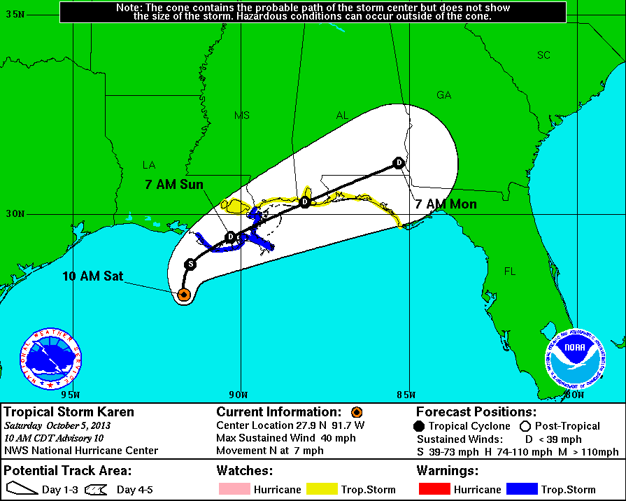
11 AM Update | Expect to Move Over Southeastern Louisiana Tonight
Tropical Storm Karen is now moving to the North at 7 mph with maximum sustained winds of 40 mph. Pressure is up again from early this morning to 1008 mb. Previous watches and warnings remain in effect and unchanged. Karen is forecasted to being making a turn to the northeast tonight and move over southeastern Louisiana tonight and into early Sunday. Tropical storm force winds are reaching outward to 115 miles mostly to the east and southeast of the center.
5 AM Update | Tropical Storm Karen Continues to Weaken
Tropical Storm Karen has weakened overnight with maximum sustained winds dropping to 40 mph and a pressure climbing to 1007 mb. Karen has also changed course and is now working herself northwest at 10 mph. Tropical Storm Karen is located 180 miles south of the mouth of the Mississippi River. The reach of Karen is also shrinking, with tropical storm force winds are now reaching outward up to 115 miles from the center. The previous watches and warnings are still in effect and unchanged.
Karen is not expected to change in intensity today and tonight, and is expected to pass over or near the mouth of the Mississippi River in about 24-36 hours before final landfall in Alabama or the Western Florida Panhandle in 36-58 hours. There serveral possible scenarious that could play out over the next few days. Karen could remain as is until final landfall, she could strengthen if convection moves towards the center, or she weakens before landfall.
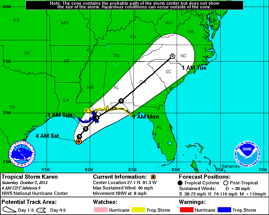
Watches & Warnings as of 5 AM
A tropical storm warning is in effect from from Morgan City, LA eastward to the mouth of the Pearl River. Metropolitan New Orleans, Lake Maurepas, and Lake Pontchartrain are NOT included in the hurricane watch at this time.
A tropical storm watch is in effect from East of the mouth of the Pearl River eastward to Indian Pass, FL. Metropolitan New Orleans, Lake Maurepas, and Lake Pontchartrain are included in the hurricane watch at this time.
Tropical Storm Karen | System History
This table contains the NHC’s statistics for the tropical cyclone from each advisory.
| Date | Time (EST) | Classification | Max Winds (mph) | Movement/Speed | Pressure (mb) |
| Oct 3 | 8 AM | Tropical Storm | 60 | NNW at 13 mph | 1004 |
| 11 AM | 65 | NNW at 12 mph | 1004 | ||
| 2 PM | 65 | NNW at 12 mph | 1004 | ||
| 5 PM | 65 | NNW at 12 mph | 999 | ||
| 8 PM | 65 | NNW at 12 mph | 999 | ||
| 11 PM | 65 | NNW at 10 mph | 999 | ||
| Oct 4 | 5 AM | 60 | NW at 10 mph | 1002 | |
| 8 AM | 60 | NNW at 10 mph | 1003 | ||
| 11 AM | 50 | NNW at 10 mph | 1003 | ||
| 2 PM | 50 | NNW at 9 mph | 1003 | ||
| 5 PM | 50 | NNW at 7 mph | 1003 | ||
| 8 PM | 50 | Stationary | 1002 | ||
| 11 PM | 45 | NNW at 7 mph | 1002 | ||
| Oct 5 | 2 AM | 40 | NNW at 8 mph | 1004 | |
| 5 AM | 40 | NNW at 8 mph | 1007 | ||
| 8 AM | 40 | N at 10 mph | 1008 | ||
| 11 AM | 40 | N at 7 mph | 1008 | ||
| 2 PM | 40 | Stationary | 1009 | ||
| 5 PM | 40 | N at 2 mph | 1007 | ||
| 8 PM | 40 | Stationary | 1007 | ||
| 11 PM | Tropical Depression | 35 | Stationary | 1008 |