
11 PM Update | Tropical Storm Erin Yet to Strengthen
Tropical Storm Erin has not strengthened this evening as she moves west-northwest across the Atlantic at 15 mph with maximum sustained winds of 40 mph. TS Erin is positioned roughly 340 miles west of the Cape Verde Islands. The estimated minimum central pressure has risen to 1007 mb.
Erin is still expected to slow down while continuing to move west-northwest over the next couple of days, but is still in a favorable environment for intensification.
The promising news this evening is the shift we mentioned during the 5 PM update has indeed occurred, shifting to the North. The global models show a turn to the North early next week, however, the NHC track (red line with red circles below) remains south of the forecast models consensus for now. The NHC is playing it safe due to some uncertainty in the ridge that may weaken and allow the system to track west.
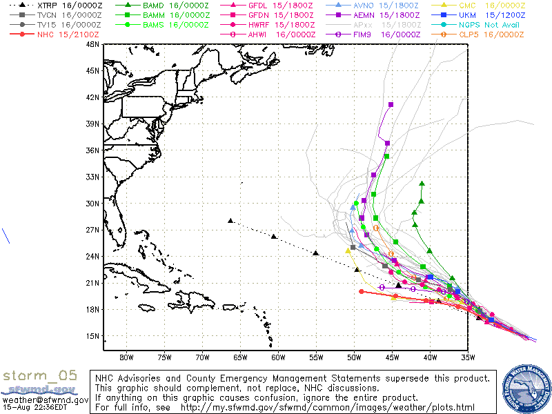
Even better is the expected weakening in 5 days to a tropical depression on Tuesday night.
5 PM Update | Tropical Storm Erin Moving Across Atlantic
Tropical Storm Erin transatlantic crossing continues to slow and is now moving west-northwest at 14mph with maximum sustained winds holding at 40 mph. Her tropical storm force reach has decreased and are only extending outward up to 35 miles. TS Erin is presently located 245 miles west-southwest of the Cape Verde Islands with pressure holding at 1006 mb. Erin’s forward movement is expected decrease while remaining on this track over the next couple of days.
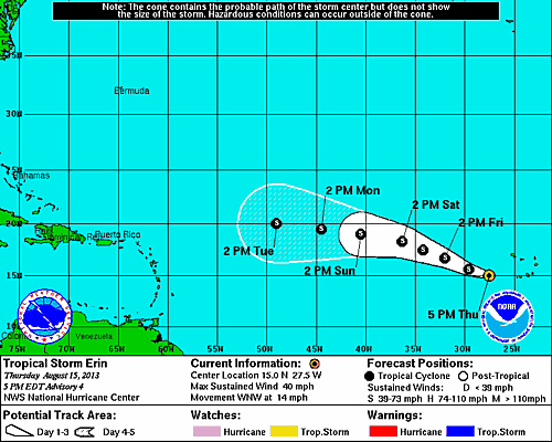
Modest strengthening is still expected over the next few days while conditions remain favorable before colliding with a dryer air mass which will help to weaken Tropical Storm Erin.
Over the duration of the day the forecast track has shifted incrementally to the north. There could be an additional shift north will be likely if the global models continue to show a northward trend. YOu can see in the spaghetti model above that the NHC forecast track (red line with red circles) is the the south of the other model runs. If a the models continue to shift Erin to the north in the next model run, the NHC forecast will be adjusted accordingly.
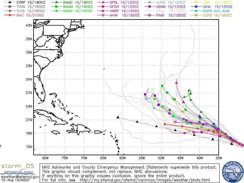
11 AM Update | Tropical Storm Erin Moving Away from the Cape Verde Islands
Tropical Storm Erin is now approximately 115 miles west southwest of Brava in the Cape Verde Islands moving to the west northwest at 15 mph, a slight slowdown from the 8AM advisory. Estimated minimum central pressure remains at 1006 mb as well as the maximum sustained winds of 40 mph. Tropical storm force winds are extending outward up to 35 miles, primarily to the east of the center.
The tropical storm warning previously in effect for the southern Cape Verde Islands has been discontinued.
Erin is expected to remain over an area of moist air, warm sea surface temperatures and low shear all which will aid in strengthening the storm over the next 3 days. By Saturday, Erin will encounter a drier air mass which should result in a weakening. The long range models are split, with some showing a weak dissipating system by day 5 where others show just the opposite and even slight strengthening. The official forecast from the National Hurricane Center is siding with the models that have Erin weakening.
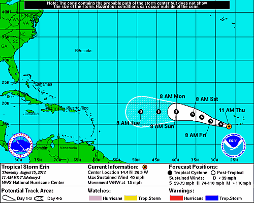
8 AM Update | Tropical Depression 5 Becomes Tropical Storm Erin
The National Hurricane Center issued an intermediate advisory at 8AM as Tropical Depression 5 has intensified based on satellite imagery to the 5th named storm of 2013, Tropical Storm Erin. At this hour, TS Erin was located 65 miles West Southwest of Brava in the Cape Verde Islands moving West Northwest at 16 mph. Maximum sustained winds are up to 40 mph with an estimated central minimum pressure of 1006 mb.
The tropical storm warning for the Cape Verde Islands of Maio, Santiago, Fogo, and Brava remain in effect. Tropical storm force winds are extended outwards of 35 miles from the center of circulation.

Tropical Storm Erin will move away from the Cape Verde Islands into the open water of the Atlantic Ocean. The forecast track continues on the current heading until Sunday when Erin will take a turn to the West towards the Lesser Antilles.
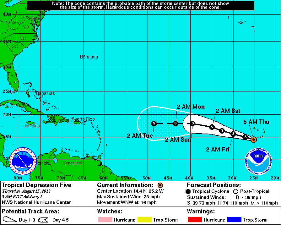
5 AM Update | Tropical Depression 5 Approaching TS Strength
Tropical Depression 5 is presently located 45 southwest of the Brava in the Cape Verde Islands off the west coast of Africa moving West Northwest at 16 mph with maximum sustained winds of 35 mph. The estimated minimum central pressure dropped to 1007 mb. Satellite imagery suggests TD5 is becoming better organized. Tropical Depression 5 will more than likly strengthen to a tropical storm in the next few hours it moves over an area with warm sea surface temperatures and little vertical sheer to disrupt circulation.
System History
This table contains the NHC’s statistics for the tropical cyclone from each advisory.
| Date | Time (EST) | Classification | Max Winds (mph) | Movement/Speed | Pressure (mb) |
| Aug 14 | 11 PM | Tropical Depression | 35 | WNW at 14 mph | 1008 |
| Aug 15 | 5 AM | 35 | WNW at 16 mph | 1007 | |
| 8 AM* | Tropical Storm | 40 | WNW at 16 mph | 1006 | |
| 11 AM | 40 | WNW at 15 mph | 1006 | ||
| 5 PM | 40 | WNW at 14 mph | 1006 | ||
| 11 PM | 40 | WNW at 15 mph | 1007 |