
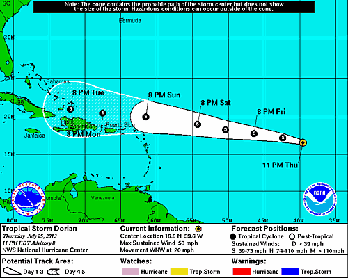
11 PM Update – Weakens this Evening
Tropical Storm Dorian has weakened a bit this evening with the maximum sustained winds dropping to 50 mph and a central pressure increasing to 1001mb. Tropical storm force winds continue to stretch out up to 60 miles. TS Dorian is presently located 1550 miles east of the Northern Leeward Island and moving west-northwest at 20 mph. The system is expected to speed up on Friday due to the high pressure system in the Central Atlantic. The forecast track has shifted to the south a bit as a result of the high pressure system. Finally, the intensity forecast has been reduce fore the end of the forecast track to 60 mph versus the previous estimate of 70 mph.
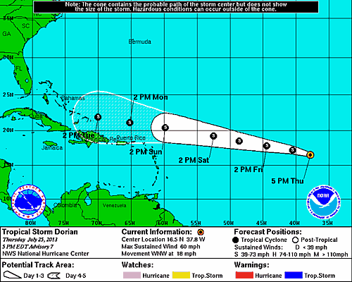
5 PM Update – Status Quo for Dorian, Again.
Tropical Storm Dorian’s status remains the same this evening. Dorian is moving slightly faster at 18 mph on a west-northwest track with maximum sustained winds of 60 mph and an estimated central pressure of 999 happy haunts, oops I meant millibars. (sorry, just trying to keep it fresh.) The tropical storm is presently located approximately 1670 miles east of the Northern Leeward Islands. The models continue to be in agreement on the forecast track, but differ in terms of the forward speed and intensity. The National Hurricane Center is leaning towards the models which have proven accurate thus far which are forecasting a slower moving system. TS Dorian is expected gradually strengthen over the next 3 to 4 days while in an area of low sheer. The 5 day outlook becomes harder to pinpoint as there is some uncertainty with regards the whether or not Dorian will encounter an area of moderate to strong southwesterly shear conditions which could help weaken the system.
11 AM Update – Status Quo for Dorian
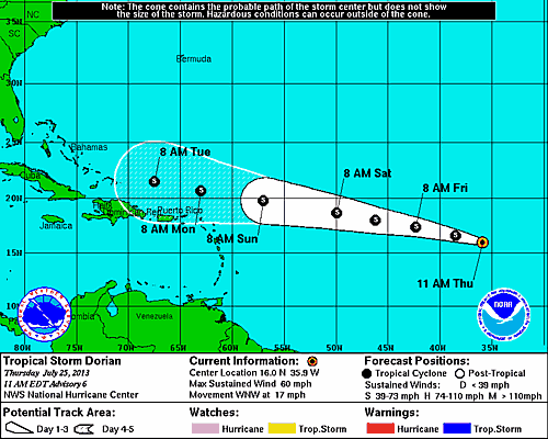
Tropical Storm Dorian has not changed over the last 6 hours. TS Dorian remains on a west-northwest course moving at 17 mph with maximum sustained winds of 60 mph. After dropping overnight, the estimated minimum central pressure remains at 999 mb. The center of circulation is approximately 1800 miles east of the Northern Leeward Islands. The forecast indicates a slight turn towards the west on Friday. The NHC’s confidence in the forecast track is excellent, but models have differing option on the systems forward speed and intensity. Faster forward movement yields a lower intensity, while a slower moving system could become stronger. At this time, the forecast is hedging to the side of a slower moving system. The new intensity model indicates Tropical Storm Dorian will be close to 70 mph at the beginning of next week at same time the Disney Fantasy is steaming toward St Maarten.
5 AM Update – Dorian Strengthens Slightly Overnight
Tropical Storm Dorian found a way to strengthen overnight with a drop in pressure from 1002 mb at 11 PM to 999 mb and maximum sustained winds up to 60 mph. Dorian’s west-northwest forward movement has slowed a bit to 17 mph. The center of circulation is located approximately 700 miles west of the Cape Verde Islands. Dorian is also growing in size with tropical storm force wind reaching outward up to 60 miles.
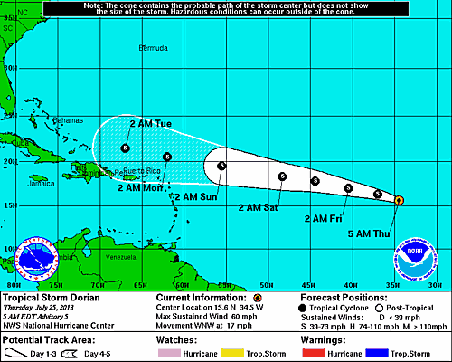
The official forecast track from the National Hurricane Center has been nudged a bit to the north based on the latest model runs. The forecast track models continue to be in agreement.
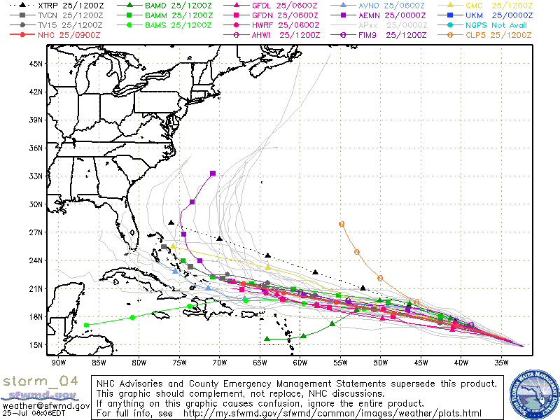
While the forecast track may be in agreement, the intensity models are still all over the place. Over the next 2 to 3 days TS Dorian will move over warmer water adding a little fuel to the system. The official forecasts shows little intensification through Friday with maximum sustained winds reaching 65 mph by the end of the weekend.
As of this morning, due to the current location of the system there are no recon flights schedule for today or tomorrow. This means the forecast will continue to be based on satellite data and model analysis. The official NHC forecast could change drastically in either direction once live, realtime data is collected and analyzed.
System History
| Date | Time | Classification | Max Winds (mph) | Movement/Speed | Pressure (mb) |
| July 24 | 5AM EST | Tropical Depression | 35 | WNW at 20 mph | 1008 |
| 11AM EST | Tropical Storm | 50 | WNW at 21 mph | 1002 | |
| 5PM EST | 50 | WNW at 20 mph | 1002 | ||
| 11PM EST | 50 | WNW at 20 mph | 1002 | ||
| July 25 | 5AM EST | Tropical Storm | 60 | WNW at 17 mph | 999 |
| 11AM EST | 60 | WNW at 17 mph | 999 | ||
| 5PM EST | 60 | WNW at 18 mph | 999 | ||
| 11PM EST | 50 | WNW at 20 mph | 1001 |