
We normally do not track tropical systems in the Pacific as the focus is usually in the Bahamas and Caribbean, but the Disney Wonder is scheduled to arrive in San Diego Friday morning and depart on a 14-night Eastbound Panama Canal Cruise Friday evening. Early Wednesday morning, a tropical depression developed south of Mexico and has since strengthened into Tropical Storm Odile. TS Odile is forecast to remain over open waters while moving northwest align the west coast of Mexico.
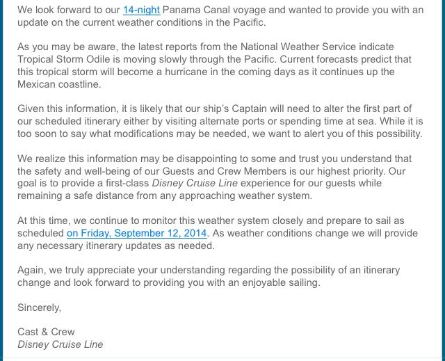
Disney Cruise Line has sent email to guests sailing on the Panama Canal Cruise to let them know the cruise will sail as planned, but the Captain may need to alter the first few days to avoid Odile. The following is a copy of the email from DCL which was shared by a passenger booked on the cruise.
11 PM PDT Update | Tropical Strom Odile Drifting West-Northwestward
Tropical Storm Odile is approximately 245 miles south of Manzanillo, Mexico with maximum sustained winds up to 60 mph. Tropical storm force winds are extending outward up to 105 miles from the center. Odile could become a hurricane by Friday night.
2 PM PDT Update | Tropical Strom Odile Moving Little
Tropical Storm Odile is approximately 260 miles south west of Lazaro Cardenas, Mexico with maximum sustained winds up to 60 mph. The NHC is forecasting that TS Odile will reach hurricane strength on Friday and is already showing signs of strengthening with a pressure drop of 2 mb and winds up 10 mph.
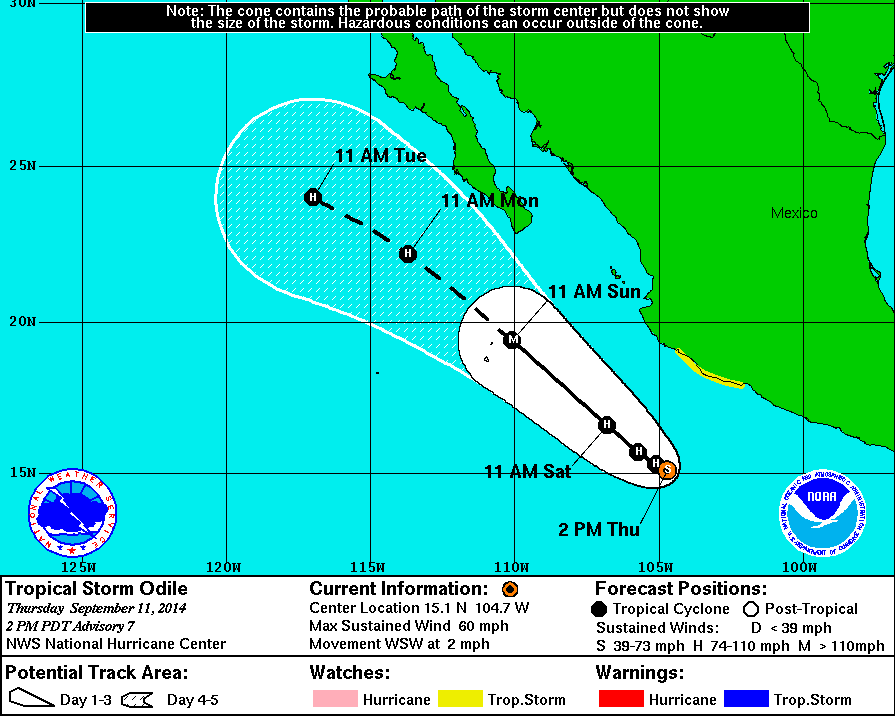
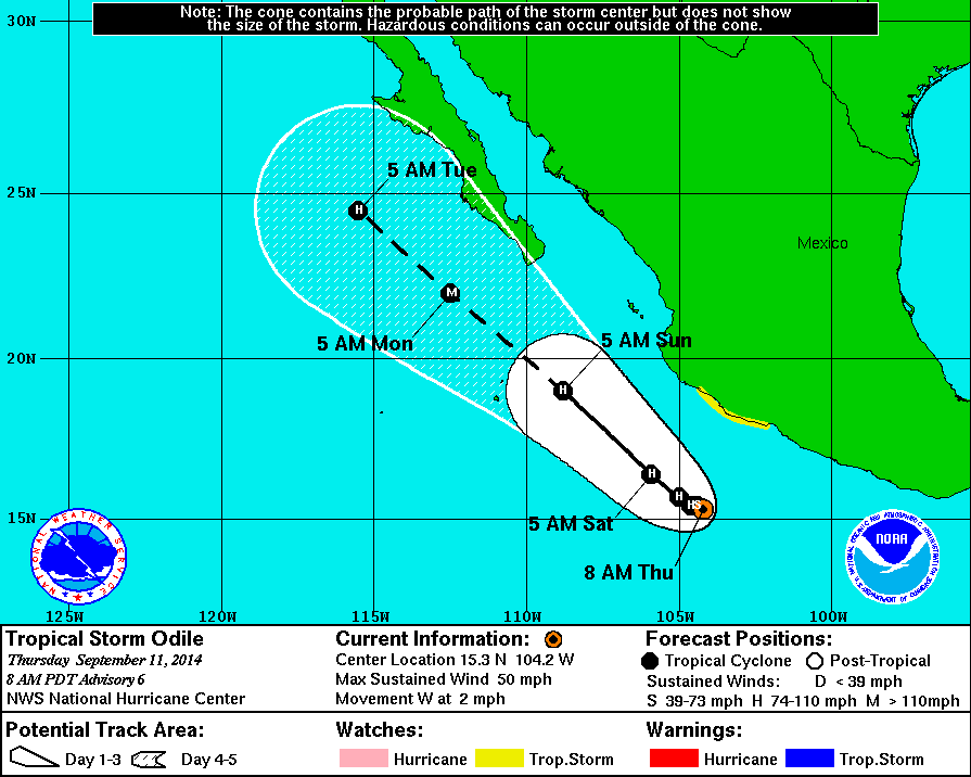
11 AM PDT Update | Tropical Strom Odile Moving Little
Tropical Storm Odile is approximately 250 miles south west of Lazaro Cardenas, Mexico with maximum sustained winds of 50 mph. The NHC is forecasting that TS Odile will reach hurricane strength on Friday.
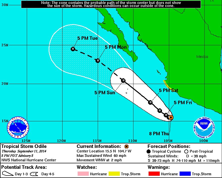
8 AM PDT Update | Tropical Strom Odile Drifting Westward – Expect to Strengthen
Tropical Storm Odile is approximately 230 miles south west of Lazaro Cardenas, Mexico with maximum sustained winds of 50 mph. The NHC is forecasting that TS Odile will reach hurricane strength on Friday.
Tropical Cyclone History | Odile
This table contains the NHC’s statistics for the tropical cyclone from each advisory.
| Date | Time (PDT) | Classification | Max Winds (mph) | Movement/Speed | Pressure (mb) |
| Sep 10 | 2 AM | Tropical Depression (TD15-E) |
35 | NNW at 1 mph | 1006 |
| 8 AM | Tropical Storm | 40 | NW at 3 mph | 1005 | |
| 2 PM | 40 | NW at 6 mph | 1004 | ||
| 8 PM | 45 | NW at 3 mph | 1001 | ||
| 11 PM | 45 | NW at 2 mph | 1001 | ||
| Sep 11 | 2 AM | 50 | W at 2 mph | 999 | |
| 5 AM | 50 | W at 1 mph | 999 | ||
| 8 AM | 50 | W at 3 mph | 999 | ||
| 11 AM | 50 | W at 2 mph | 999 | ||
| 2 PM | 60 | WSW at 2 mph | 997 | ||
| 8 PM | 60 | WNW at 2 mph | 996 |