
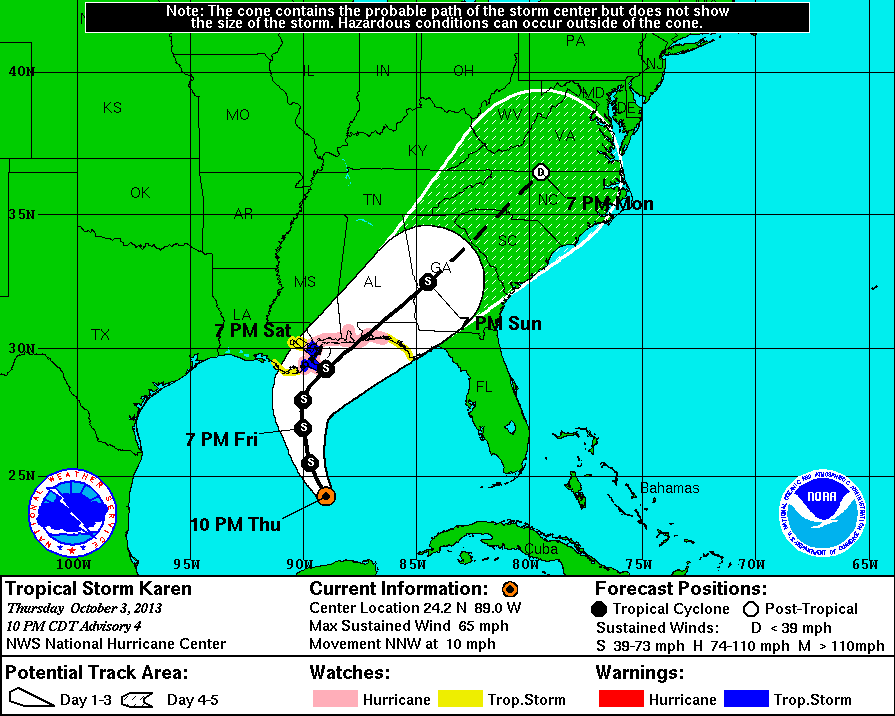
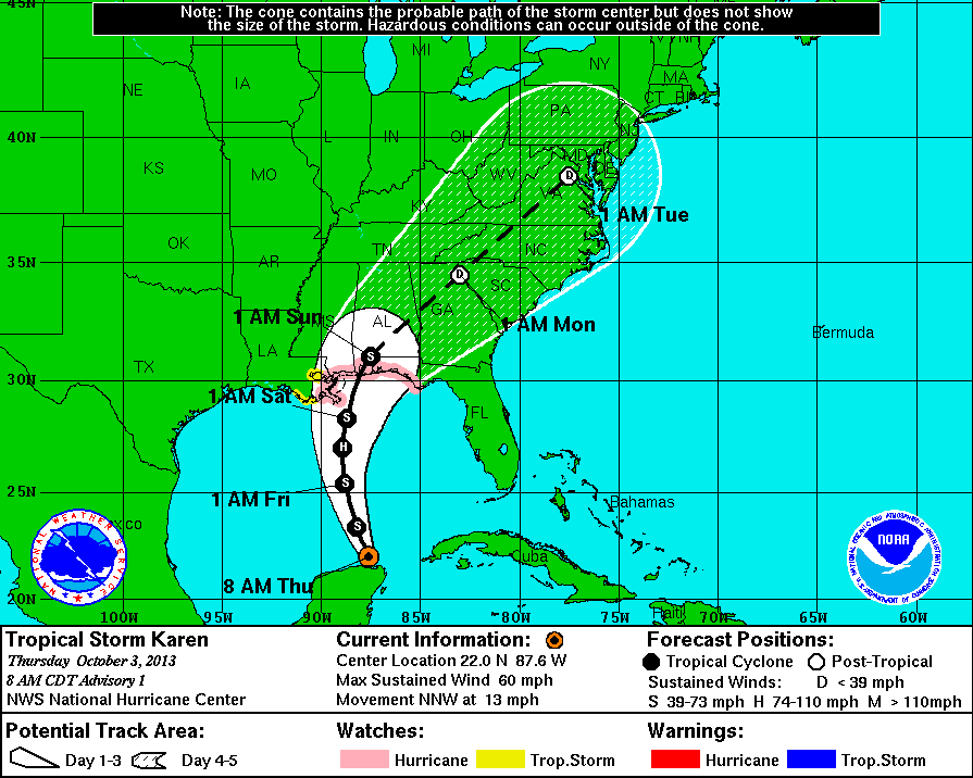
11 PM Intermediate Update | Tropical Storm Karen Moving Slower
Tropical Storm Karen remains on a north-northwest course at a slightly slower forward speed of 10 mph with maximum sustained winds still at 65 mph and a minimum central pressure of 999 mb. TS Karen is moving into the Central Gulf of Mexico approximately 340 miles south of the mouth of the Mississippi River. Tropical storm force winds are still reaching outward up to 140 miles from the center. The watches and warnings from the 5 PM update are still in effect and unchanged.
Karen is expected to make a turn to the north and decrease in forward speed over night into Friday, with a turn to the northeast on Saturday. Karen is experiencing some shear that is forecast to increase which would result in a weakening of the tropical storm. The National Hurricane Center’s intensity forecast indicates that Karen may no longer reach hurricane strength. The 11 PM forecast track is very similar to the previous intermediary update track.
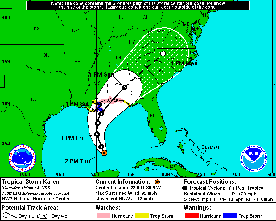
8 PM Intermediate Update | Tropical Storm Karen Maintaining Course
Tropical Storm Karen has not changed much in the last 3 hours. Karen remains on a north-northwest course at 12 mph with maximum sustained winds of 65 mph and a minimum central pressure of 999 mb. TS Karen is moving into the Central Gulf of Mexico approximately 360 miles south of the mouth of the Mississippi River. Tropical storm force winds are still reaching outward up to 140 miles from the center. The watches and warnings from the 5 PM update are still in effect and unchanged.
Karen is expected to make a turn to the north and decrease in forward speed over the next 48 hours. During the day tomorrow she is expected to gradually intensify to near hurricane strength.
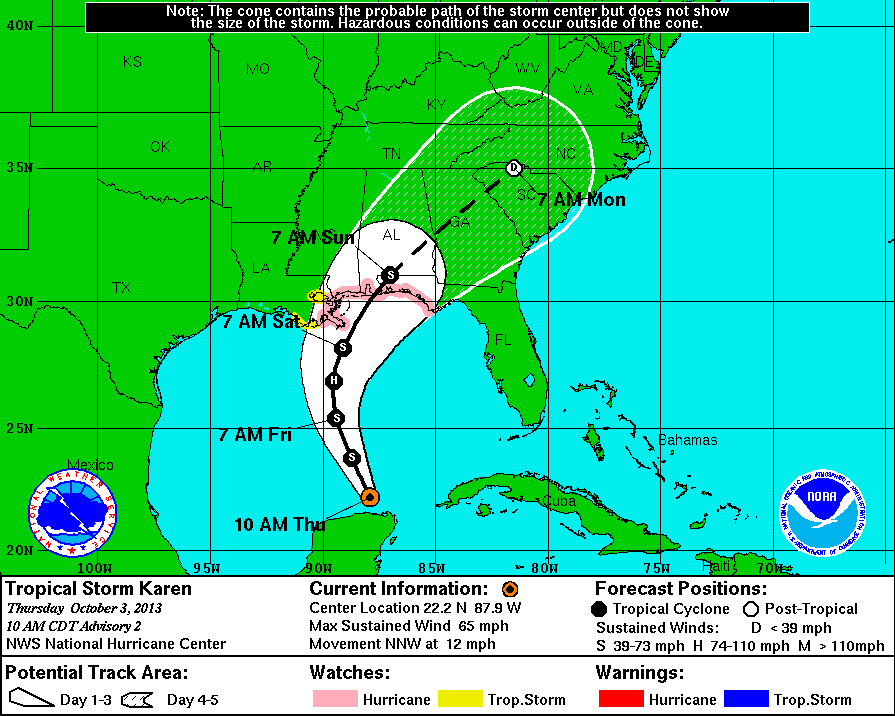
5 PM Update | Tropical Storm Warning Extended to Southeastern Louisiana
Tropical Storm Karen is a little stronger with a significant drop in pressure to 999 mb. TS Karen is producing maximum sustained winds of 65 mph with tropical storm force winds extending up to 140 miles (an increase). TS Karen is roughly 400 miles south of the Mississippi River delta. Karen remains on a north-northwest heading at 12 mph.
Although Karen looks less impressive on the satellite, she continues to maintain her intensity this evening. Gradual strengthening is expected over the next 48 hours and then some weakening as she approaches the Gulf Coast. The National Hurricane Center continues to suggest that Karen could still be near hurricane strength at landfall. The official forecast track has shifted to the west triggering a tropical storm warning for portions of Southeastern Louisiana.
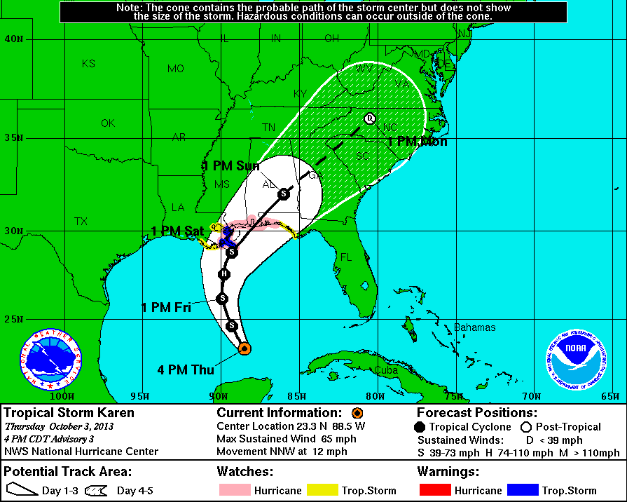
Watches & Warnings as of 5 PM
A tropical storm warning is in effect from from Grand Isle, LA eastward to the mouth of the Pearl River. Metropolitan New Orleans, Lake Maurepas, and Lake Pontchartrain are NOT included in the hurricane watch at this time.
A tropical storm watch is in effect from Grand Isle, LA eastward to Indian Pass, FL. Metropolitan New Orleans, Lake Maurepas, and Lake Pontchartrain are included in the hurricane watch at this time.
A hurricane watch is in effect from Grand Isle, LA eastward to west of Destin, FL. Metropolitan New Orleans, Lake Maurepas, and Lake Pontchartrain are NOT included in the hurricane watch at this time.
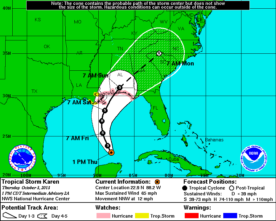
2 PM Intermediate Update | Expected to Reach Gulf Coast on Saturday
Tropical Storm Karen is a little stronger with maximum sustained winds of 65 mph with tropical storm force winds extending up to 105 miles. TS Karen is roughly 430 miles south of the Mississippi River delta. Karen remains on a north-northwest heading at 12 mph and a minimum central pressure of 1004 mb. There a no changes to the earlier watches or warnings.
A decrease in forward speed is expected over the next 48 hours. Tropical storm conditions are likely to reach the gulf coast within portions of the hurricane watch area on late Friday, with hurricane conditions arriving Saturday morning. Storm surge estimates ranges from 1 to 4 feet above ground if surge occurs during a period of high tide. The highest surge will occur from the center of Karen and to the east.
11 AM Update | Tropical Storm Karen a Little Stronger
Tropical Storm Karen is a little stronger with maximum sustained winds up 5 mph to 65 mph with tropical storm force winds extending up to 105 miles. TS Karen is roughly 485 miles south of the Mississippi River delta. Karen remains on a north-northwest heading at 12 mph and a minimum central pressure of 1004 mb. There a no changes to the earlier watches or warnings.
Additional strengthening is expected over next day or so with most of the activity to the northeast of the center. The National Hurricane Center anticipates some weakening as Karen approached the Gulf Coast, but still could be near hurricane strength at landfall. Tropical storm conditions are possible by late Friday night within portions of the hurricane watch area with hurricane conditions arriving by Saturday morning.
8 AM Update | Invest 97L Develops into Tropical Storm Karen
This morning’s Air Force Hurricane Hunter recon flight determined that Invest 97L does have a closed area of circulation with maximum sustained winds recorded at 60 mph. As a result, the National Hurricane Center officially named the Invest 97L, Tropical Storm Karen. TS Karen is located over the Southeastern Gulf of Mexico just north of Mexico’s Yucatan Peninsula. The system is expected to continue moving north-northwest towards the Gulf Coast of the United States with a gradual turn to the north with a decreased forwards speed over the course of the next 2 days. Tropical storm force winds are extending outward up to 90 miles from the center of of circulation with the strongest winds observed north and east of the center. Gradual intensification is possible and could reach hurricane strength Friday. Overall, the forecast tracks show a significant east to west spread which should become better define as the models analyze the latest data sets.
Watches & Warnings at 8 AM
A tropical storm watch has been issued from Grand Isle, LA eastward to Indian Pass, FL. Metropolitan New Orleans, Lake Maurepas, and Lake Pontchartrain are included in the hurricane watch at this time.
A hurricane watch has been issued from Grand Isle, LA eastward to Indian Pass, FL. Metropolitan New Orleans, Lake Maurepas, and Lake Pontchartrain are NOT included in the hurricane watch at this time.
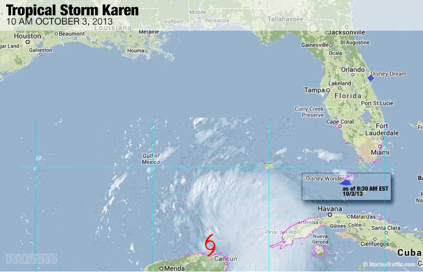
The Disney Wonder, sailing her first 7-night Bahamian cruise this fall, is currently en route back to Galveston, Texas from her last port of call, Nassau. On Saturday, the Disney Wonder is schedule to sail a 7-Night Western Caribbean cruise, which based on the current forecast should not cause an problems as Karen will be well to the east of Texas. The map below is a composite of the visual satellite and the Disney Wonder approximately at 9:30 AM – 10:00 AM. The Disney Fantasy may show up later when she is in range of an AIS receiver en route to Castaway Cay from Cozumel.
Tropical Storm Karen | System History
This table contains the NHC’s statistics for the tropical cyclone from each advisory.
| Date | Time (EST) | Classification | Max Winds (mph) | Movement/Speed | Pressure (mb) |
| Oct 3 | 8 AM | Tropical Storm | 60 | NNW at 13 mph | 1004 |
| 11 AM | 65 | NNW at 12 mph | 1004 | ||
| 2 PM | 65 | NNW at 12 mph | 1004 | ||
| 5 PM | 65 | NNW at 12 mph | 999 | ||
| 8 PM | 65 | NNW at 12 mph | 999 | ||
| 11 PM | 65 | NNW at 10 mph | 999 |
I bet there is going to be some horror stories from the Wonder once she does make it back to port. I really don’t know how this one could have been avoided since it looks like it just formed up as soon as it got over the water. The poor Wonder has no clean path back to port. It looks like these people are in for a rough ride. The Fantasy will probably get beat around a little bit too before it gets around the southern tip and out of the path of those winds.
Just off the Wonder this morning and no horror stories. Captain Thord did an amazing job of sailing around the southern edge of the storm. The only effects we felt were some slightly high seas (we were told they were in the 10 foot range) and some high winds on deck. The worst of it was in the middle of the night, and it was not bad at all. My kids didn’t even notice anything was going on!
Good to hear! Thanks for the update.
We rocked and rolled on the Fantasy for about 6 hours. Seasick people didnt have a fun time with it, and the poor crew was out strapping things down. But at about 2am we punched through the other side, and it was smooth sailing again. Kudos to the crew, who did a great job with safety and making sure everyone knew we would be fine, despite the motion.
Thanks for the report!