
11 PM Update | Karen’s Loosing Steam
Following Tropical Storm Karen break earlier this evening, she is back on the move heading north-northwest at 7 mph. TS Karen is loosing steam tonight with maximum sustained winds down to 45 mph, but the minimum central pressure is holding at 1002 mb.. This weakening is mostly due to a strong southwesterly shear and dry air to the west. Tropical Storm Karen is located 205 miles south-southwest of the mouth of the Mississippi River. Tropical storm force winds are still reaching outward up to 140 miles from the center. The strongest winds are still located to the north and east of the center of circulation.
There are no changes to the watches or warnings that were put in effect at the 5 PM update.
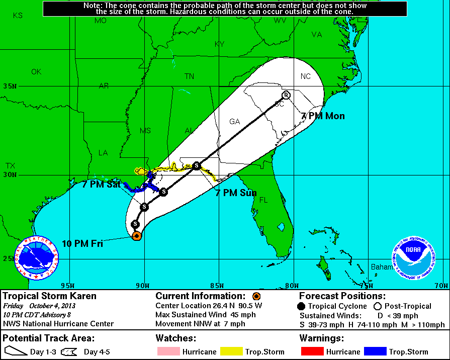
Tropical storms rarely recover after being depreciated by strong shear, especially in an area dry air like it is the case in the western Gulf of Mexico. The latest recon flight data indicates a that Karen maintains a well defined circulation, but the winds are decreasing. According the the National Hurricane Center, there is a small window of opportunity for Karen to strengthen if the shear relaxes. Karen will make a sharp turn to the northeast on Saturday and increase her forward speed while maintaining her present intensity. Most of the models are in agreement with this forecast track.
8 PM Update | Karen’s On Break
Tropical Storm Karen decided to take a break this evening, in fact, she has not moved in a few hours. TS Karen’s maximum sustained winds are holding at 50 mph and pressure dipped to 1002 mb. Tropical Storm Karen is located 235 miles south-southwest of the mouth of the Mississippi River. Tropical storm force winds are still reaching outward up to 140 miles from the center. The strongest winds are still located to the north and east of the center of circulation.
There are no changes to the watches or warnings that were put in effect at the 5 PM update.
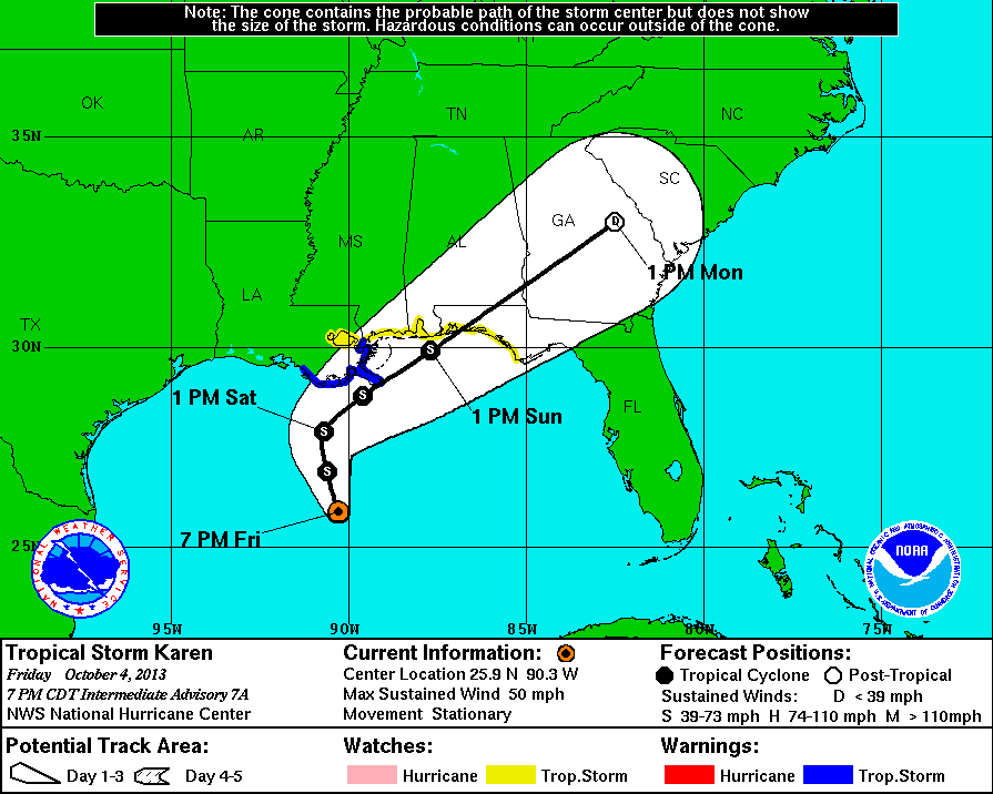
While there has been little movement, she is expected to resume a north-northwest heading at about 7 mph later tonight. Eventually, she will turn to the north and slow down before heading northeast on the forecast track. The center is expected to be near the coast of Southeastern Louisiana on Saturday night.
5 PM Update | Hurricane Watch Discontinued
Tropical Storm Karen’s maximum sustained winds are holding at 50 mph with pressure at 1003 mb, and remains on a north-northwest heading which has slowed to 7 mph. Tropical Storm Karen is located 235 miles south-southwest of the mouth of the Mississippi River. Tropical storm force winds are still reaching outward up to 140 miles from the center. The strongest winds are still located to the north and east of the center of circulation.

Karen is a bit disorganized at this hour and as a result the hurricane watch previously in effect has been changed to tropical storm watch from the mouth of the Pearl River to Destin, Florida. There are no areas at this time with a hurricane watch or warning!
Watches & Warnings as of 5 PM
A tropical storm warning is in effect from from Morgan City, LA eastward to the mouth of the Pearl River. Metropolitan New Orleans, Lake Maurepas, and Lake Pontchartrain are NOT included in the hurricane watch at this time.
A tropical storm watch is in effect from East of the mouth of the Pearl River eastward to Indian Pass, FL. Metropolitan New Orleans, Lake Maurepas, and Lake Pontchartrain are included in the hurricane watch at this time.
2 PM Intermediate Update | Karen Headed for the Gulf Coast
Tropical Storm Karen’s maximum sustained winds are holding at 50 mph with pressure at 1003 mb. Karen course remains on a north-northwest heading slowing to 9 mph. Karen continues to be dampened by dry air to the west and westerly shear. Tropical Storm Karen is located 240 miles south-southwest of the mouth of the Mississippi River. Tropical storm force winds are still reaching outward up to 140 miles from the center. The strongest winds are still located to the north and east of the center of circulation. There are no changes to the watches or warnings that were put in effect at the 11 AM update.
Karen is expected to change begin turning to the north with a decreased forward speed overnight into Saturday morning. Followed by a turn to the northeast on Sunday as she speeds up with the center of circulation making landfall within the tropical storm warning area Saturday night.

11 AM Update | Tropical Storm Karen A Little Weaker
Tropical Storm Karen’s maximum sustained winds dropped from 60 mph to 50 mph with pressure holding at 1003 mb. Karen course remains on a north-northwest heading at 10 mph. Karen continues to be dampened by dry air to the west and westerly shear. Tropical Storm Karen is located 250 miles south of the mouth of the Mississippi River. Tropical storm force winds are still reaching outward up to 140 miles from the center. The strongest winds are still located to the north and east of the center of circulation. The tropical storm warning has been extended westward from Grand Isle, LA to Morgan City. The hurricane watch could change to a tropical storm watch or warning later today.
Watches & Warnings as of 5 AM
A tropical storm warning is in effect from from Morgan City, LA eastward to the mouth of the Pearl River. Metropolitan New Orleans, Lake Maurepas, and Lake Pontchartrain are NOT included in the hurricane watch at this time.
A tropical storm watch is in effect from Grand Isle, LA eastward to Indian Pass, FL. Metropolitan New Orleans, Lake Maurepas, and Lake Pontchartrain are included in the hurricane watch at this time.
A hurricane watch is in effect from Grand Isle, LA eastward to west of Destin, FL. Metropolitan New Orleans, Lake Maurepas, and Lake Pontchartrain are NOT included in the hurricane watch at this time.

Karen is expected to change begin turning to the north with a decreased forward speed overnight into Saturday morning. Followed by a turn to the northeast on Sunday as she speeds up with the center of circulation making landfall within the tropical storm warning area Saturday night.
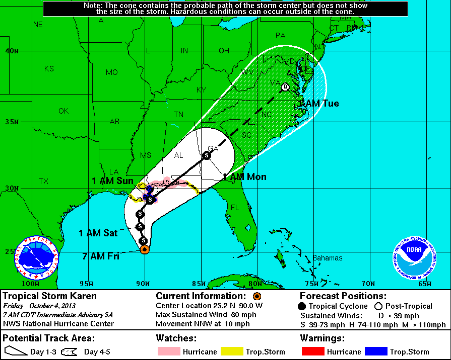
8 AM Intermediate Update | Tropical Storm Karen Moving North-Northwest
Tropical Storm Karen remains the same as the previous update with maximum sustained winds of 60 mph with a bump up in pressure increase to 1003 mb. Karen changed course again, and is now back on a north-northwest heading at 10 mph. Tropical Storm Karen is located 275 miles south of the mouth of the Mississippi River. Tropical storm force winds are still reaching outward up to 140 miles from the center. The strongest winds are located to the north and east of the center of circulation. The watches and warnings from the October 3rd 5 PM update are still in effect and unchanged.
Karen is not expected to change in intensity much today and overnight as she begins to head north, but strengthening is possible over the weekend as she begins to turn to the northeast.
Expected landfall is estimated to be within the tropical storm warning area on Saturday or Saturday night.
5 AM Update | Tropical Storm a Little Weaker
Tropical Storm Karen has weakened overnight with maximum sustained winds dropping to 60 mph and a pressure increase to 1002 mb. Karen has also changed course and is now working herself northwest at 10 mph. As of the latest fix by the Air Force Hurricane Hunters, Tropical Storm Karen is located 295 miles south of the mouth of the Mississippi River. Tropical storm force winds are still reaching outward up to 140 miles from the center. The watches and warnings from the October 3rd 5 PM update are still in effect and unchanged.
Karen is not expected to change in intensity today and tonight, but strengthening is possible over the weekend as she begins to turn to a northeast heading.
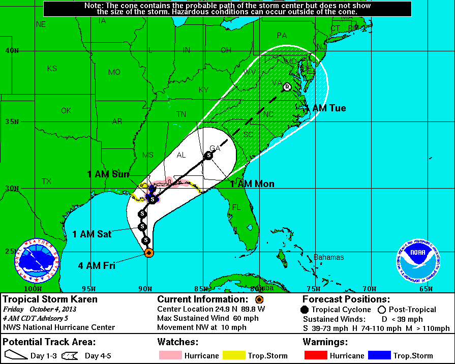
Watches & Warnings as of 5 AM
A tropical storm warning is in effect from from Grand Isle, LA eastward to the mouth of the Pearl River. Metropolitan New Orleans, Lake Maurepas, and Lake Pontchartrain are NOT included in the hurricane watch at this time.
A tropical storm watch is in effect from Grand Isle, LA eastward to Indian Pass, FL. Metropolitan New Orleans, Lake Maurepas, and Lake Pontchartrain are included in the hurricane watch at this time.
A hurricane watch is in effect from Grand Isle, LA eastward to west of Destin, FL. Metropolitan New Orleans, Lake Maurepas, and Lake Pontchartrain are NOT included in the hurricane watch at this time.
Tropical Storm Karen | System History
This table contains the NHC’s statistics for the tropical cyclone from each advisory.
| Date | Time (EST) | Classification | Max Winds (mph) | Movement/Speed | Pressure (mb) |
| Oct 3 | 8 AM | Tropical Storm | 60 | NNW at 13 mph | 1004 |
| 11 AM | 65 | NNW at 12 mph | 1004 | ||
| 2 PM | 65 | NNW at 12 mph | 1004 | ||
| 5 PM | 65 | NNW at 12 mph | 999 | ||
| 8 PM | 65 | NNW at 12 mph | 999 | ||
| 11 PM | 65 | NNW at 10 mph | 999 | ||
| Oct 4 | 5 AM | 60 | NW at 10 mph | 1002 | |
| 8 AM | 60 | NNW at 10 mph | 1003 | ||
| 11 AM | 50 | NNW at 10 mph | 1003 | ||
| 2 PM | 50 | NNW at 9 mph | 1003 | ||
| 5 PM | 50 | NNW at 7 mph | 1003 | ||
| 8 PM | 50 | Stationary | 1002 | ||
| 11 PM | 45 | NNW at 7 mph | 1002 |