
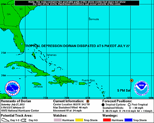
5 PM Update – Tropical Storm Dorian Degenerates into a Tropical Wave
Mother Nature finally pulled the plug on Tropical Storm Dorian this afternoon after struggling to maintain circulation for almost a day in less than favorable conditions. The remnants of Dorian are presently located about 550 miles east of the Northern Leeward Islands speeding west at 24 mph with maximum sustained winds of 40 mph…. Wait – but tropical storm force winds are 35 mph or more??? True, but the system is no longer has closed circulation; therefore it is no longer a tropical cyclone, but is just a tropical wave.
Regeneration of the system is unlikely due to dry air and the persistent southwesterly shear, which was ultimately Dorian’s nail in the coffin. The tropical wave that remains will pass north of the Leeward Island and Puerto Rico in about 2 to 3 days. The Hurricane Hunters do have a scheduled flight for tomorrow if conditions warrant.
This will be the last update on what was Tropical Storm Dorian pending any drastic changes.
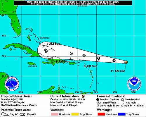
11 AM Update – Dorian Still Hanging Around
Disorganized, Tropical Storm Dorian is presently located around 720 miles east of the Northern Leeward Islands moving rapidly west at 23 mph. Maximum sustained winds remain at 40 mph with hight gusts. The estimated minimum central pressure of Dorian is holding at 1011 mb.
Dorian continues to encounter dry air and a southwester shear which should begin to affect the system soon. With the hostile e conditions ahead of Dorian a weakening to a remnant low is expected in the next day or so. Additionally, the circulation is barely closed and they system could open up into a tropical wave at any time.
The highlight of the NHC’s 11 AM update that watches and warnings are not needed for the islands of the Northeast Caribbean due to the systems given track and intensity forecast!
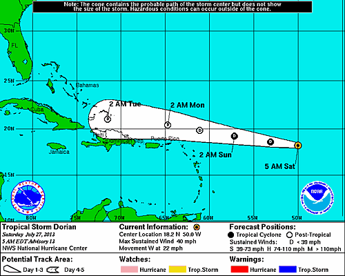
5 AM Update – Dorian Remains on Life Support
Tropical Storm Dorian remains on life support this morning while speeding west at 22 mph. As of this update, Dorian is located 860 miles east of the Northern Leeward Islands. Winds are now at 40 mph and the pressure has risen again to 1011 mb. The tropical storm force winds are now only extending outward 60 miles from north of the center of circulation.
As has been for the duration of Dorian the models are in agreement on the track this system will take regardless of intensity. Dorian is expected to experience some vertical shear and pass through a dry air mass which could pull the plug on his current lifeline. The intensity models show TS Dorian degenerating to a remnant low by Sunday night and further to a tropical wave by next week.
The environment ahead of the system is not conductive for any re-intensification.
System History
| Date | Time | Classification | Max Winds (mph) | Movement/Speed | Pressure (mb) |
| July 24 | 5AM EST | Tropical Depression | 35 | WNW at 20 mph | 1008 |
| 11AM EST | Tropical Storm | 50 | WNW at 21 mph | 1002 | |
| 5PM EST | 50 | WNW at 20 mph | 1002 | ||
| 11PM EST | 50 | WNW at 20 mph | 1002 | ||
| July 25 | 5AM EST | 60 | WNW at 17 mph | 999 | |
| 11AM EST | 60 | WNW at 17 mph | 999 | ||
| 5PM EST | 60 | WNW at 18 mph | 999 | ||
| 11PM EST | 50 | WNW at 20 mph | 1001 | ||
| July 26 | 5AM EST | 50 | WNW at 20 mph | 1001 | |
| 11AM EST | 50 | WNW at 21 mph | 1006 | ||
| 5PM EST | 45 | W at 22 mph | 1010 | ||
| 11PM EST | 40 | W at 22 mph | 1010 | ||
| July 27 | 5AM EST | 40 | W at 22 mph | 1011 | |
| 11AM EST | 40 | W at 23 mph | 1011 | ||
| 5PM EST | DISSIPATED | ||||