
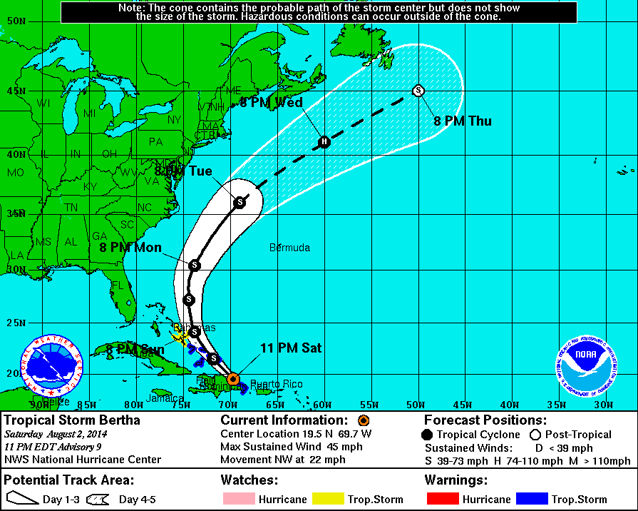
11 PM Update | TS Bertha Changes Course – Remains Disorganized
Tropical Storm Bertha is approximately 70 miles east-southeast of Puerto Plata, Dominican Republic moving northwest at 22 mph. Maximum sustained winds remain at 45 mph with TS force wind extending outward mostly to the northeast from the center 160 miles. The minimum central pressure remains at 1010 mb.
The forecast shows tropical storm Bertha move away from the northeastern coast of Dominican Republic and continue this heading through Sunday as she approaches the southeastern Bahamas and Turks and Caicos. Monday, Bertha is expected to turn to the north and head out into the open waters of the Atlantic where strengthening may occur mid week.
The tropical storm warning has been discontinued for Puerto Rico, Vieques, and Culebra.
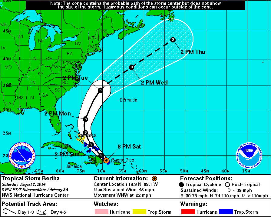
8 PM Intermediate Update | TS Bertha Moving Over Eastern Dominican Republic
Tropical Storm Bertha is approximately 60 miles east-northeast of Santo Domino, Dominican Republic moving west-northwest at 22 mph. Maximum sustained winds remain at 45 mph with TS force wind extending outward mostly to the northeast from the center 150 miles. The minimum central pressure is now up to 1010 mb.
The forecast shows tropical storm Bertha turning to the northwest tonight passing over portions of the Dominican Republic and continue this heading through Sunday as she approaches the southeastern Bahamas and Turks and Caicos. Monday, Bertha is expected to turn to the north and head out into the open waters of the Atlantic where strengthening may occur mid week.
The tropical storm warning has been discontinued for Puerto Rico, Vieques, and Culebra.
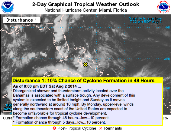
 Additionally at this hour, an area of disorganized showers and thunderstorms has emerged north of Bertha in the Bahamas. Development is expected to be limited through Sunday as it moves to the north at about 10 mph. Early next week atmospheric conditions become unfavorable for development and the NHC has it at a 10% chance of developing into a tropical cyclone.
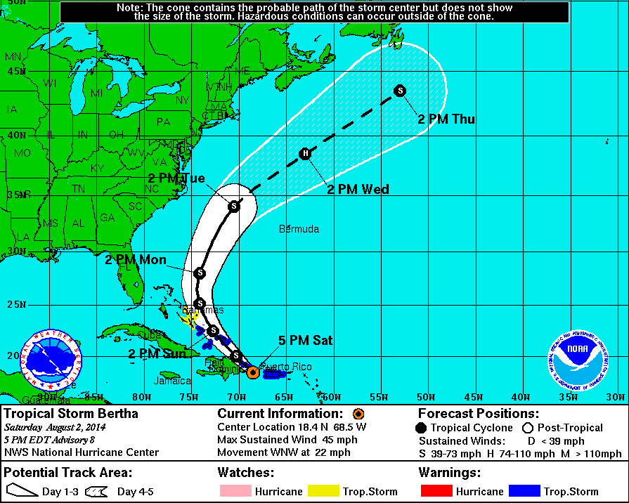
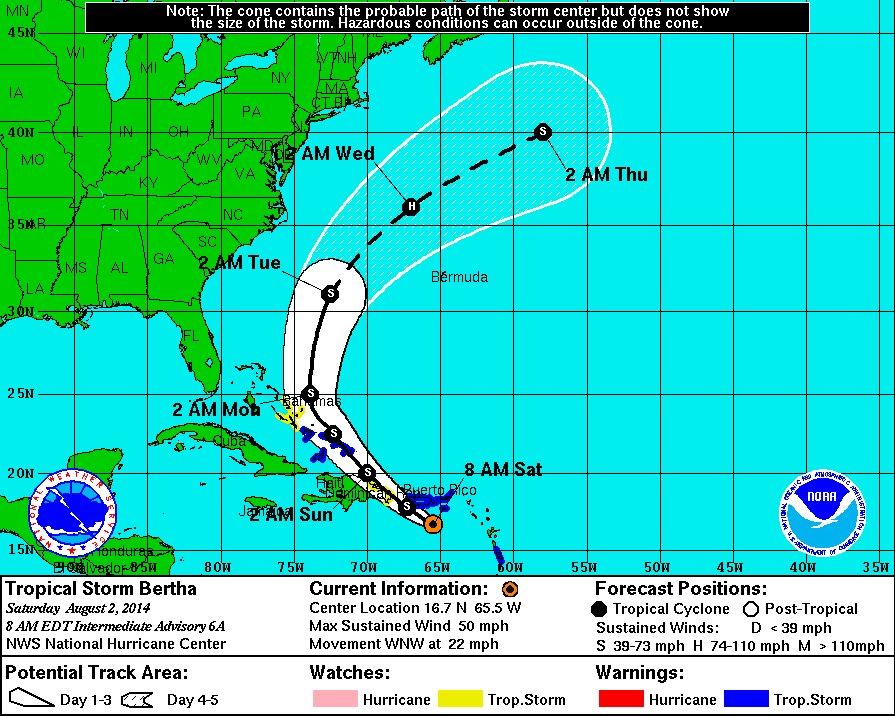
5 PM Update | TS Bertha Moving Into Eastern Dominican Republic
Tropical Storm Bertha is approximately 90 miles east of Santo Domino, Dominican Republic moving west-northwest at 22 mph. Maximum sustained winds have dropped to 45 mph with TS force wind extending outward mostly to the northeast from the center 105 miles. The minimum central pressure is now up to 1010 mb.
The forecast shows tropical storm Bertha turning to the northwest tonight passing over portions of the Dominican Republic and continue this heading through Sunday as she approaches the southeastern Bahamas and Turks and Caicos. Monday, Bertha is expected to turn to the north and head out into the open waters of the Atlantic where strengthening may occur mid week.
The tropical storm warning has been discontinued for the US Virgin Islands and British Virgin Islands.
Bertha barely qualifies as a tropical cyclone based on her characteristics at this hour according to the National Hurricane Center.
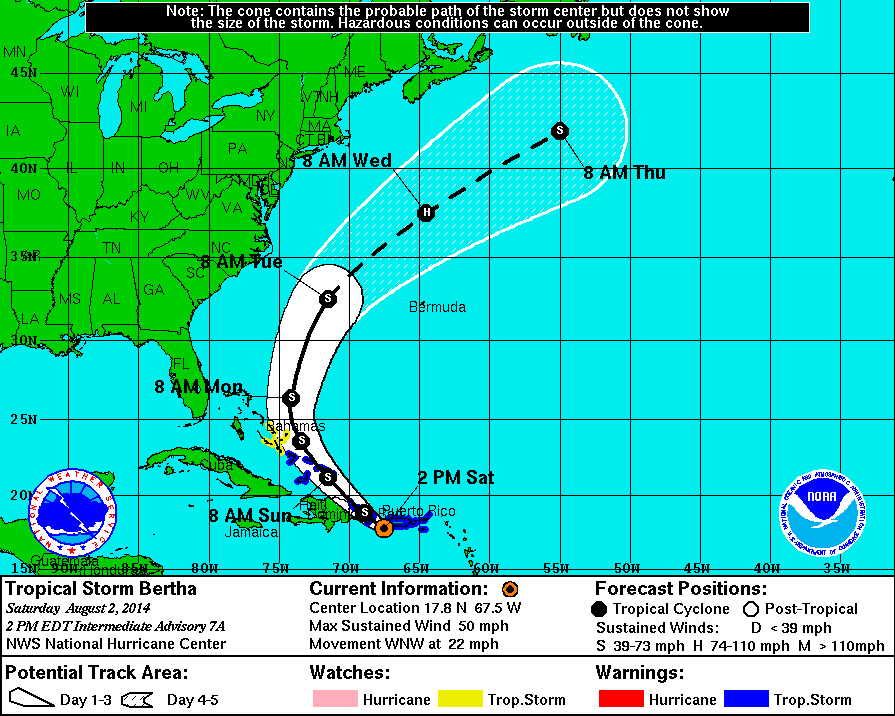
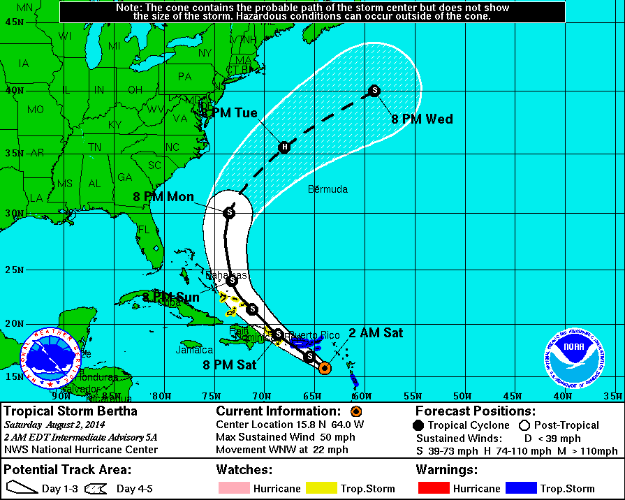
2 PM Intermediate Update | Poorly Organized TS Bertha Moving Into the Mona Passage
Tropical Storm Bertha center, which is poorly organized is approximately 110 miles west-southwest of Puerto Rico moving west-northwest at 22 mph. Maximum sustained winds remain at 50 mph with TS force wind extending outward from the center to 105 miles. The minimum central pressure is up to 1009 mb.
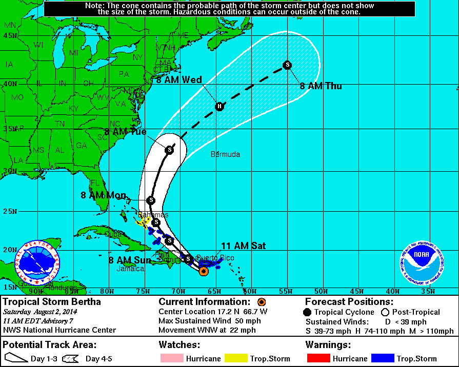
11 AM Update | TS Bertha Passing South of Puerto Rico
Tropical Storm Bertha is approximately 90 miles south-southwest of Puerto Rico moving west-northwest at 22 mph. Maximum sustained winds remain at 50 mph with TS force wind extending outward from the center to 105 miles. The minimum central pressure is holding at 1008 mb. A buoy located just south of St Thomas recorded maximum sustained winds of 44 mph with a gust of 72 mph.
The forecast expects TS Bertha to continue to move across the northeastern Caribbean Sea on her current west-northwest heading. TS Bertha will continue to pass near Puerto Rico this afternoon, and eastern Dominican Republic tonight. Bertha is forecast to turn to the northwest on Sunday before approaching the southeastern Bahamas and the Turks and Caicos islands. The official forecast track continues to show Bertha moving into the Atlantic early next week.
The Dominican Republic has issued a tropical storm warning from Cabo Frances Viejo to Isla Saona. The previous tropical storm warning in Martinique has been discontinued.
Bertha remains disorganized and it has been difficult for the NHC to find a closed circulation. The intensity forecast has Bertha briefly reaching hurricane strength on Wednesday with an estimated 75 mph winds as she is well away from land in the Atlantic ocean.
8 AM Intermediate Update | TS Bertha Generating Heavy Squalls Moving into the Virgin Islands
Tropical Storm Bertha is approximately 85 miles southwest of St Croix moving west-northwest at 22 mph. Maximum sustained winds remain at 50 mph with TS force wind extending outward from the center to 115 miles. The minimum central pressure is holding at 1008 mb. A NOAA buoy recorded maximum sustained winds of 40 mph with a gust of 45 mph.
The forecast expects TS Bertha to continue to move across the northeastern Caribbean Sea on her current west-northwest heading. TS Bertha pass near Puerto Rico this afternoon, and eastern Dominican Republic tonight. Bertha is forecast to turn to the northwest on Sunday before approaching the southeastern Bahamas and the Turks and Caicos islands. The official forecast track continues to show Bertha moving into the Atlantic early next week.
The intensity forecast has Bertha briefly reaching hurricane strength on Wednesday with an estimated 75 mph winds as she is well away from land in the Atlantic ocean.
5 AM Update | Heavy Squalls Approaching Puerto Rico and the Virgin Islands
Tropical Storm Bertha is approximately 95 miles south of St Croix moving west-northwest at 22 mph. Maximum sustained winds remain at 50 mph with TS force wind extending outward from the center to 115 miles. The minimum central pressure is holding at 1008 mb.
The Bahamas has issued at tropical storm waring for southeastern Bahamas.
The forecast expects TS Bertha to continue to move across the northeastern Caribbean Sea on her current west-northwest heading. TS Bertha pass near Puerto Rico this afternoon, and eastern Dominican Republic tonight. Bertha is forecast to turn to the northwest on Sunday before approaching the southeastern Bahamas and the Turks and Caicos islands. The official forecast track continues to show Bertha moving into the Atlantic early next week.
2 AM Intermediate Update | Tropical Storm Bertha Racing Across the Northeastern Caribbean Sea
Tropical Storm Bertha is approximately 140 miles south-southeast of St Croix moving west-northwest at 22 mph. Maximum sustained winds remain at 50 mph with TS force wind extending outward, mainly to the north and east the center to 115 miles. The minimum central pressure is up to 1008 mb.
The forecast expects TS Bertha to continue to move across the northeastern Caribbean Sea an turn to the northwest later today passing near Puerto Rico this afternoon, and eastern Dominican Republic tonight. Sunday, TS Bertha is expected to approach the southeastern Bahamas and the Turks and Caicos islands. The official forecast track continues to show Bertha moving into the Atlantic early next week.
Bertha remains in a area that is unfavorable for any additional strengthening based on data collected by a recon flight by the Air Force Reserve Hurricane Hunters.
Tropical Cyclone History | Bertha
This table contains the NHC’s statistics for the tropical cyclone from each advisory.
| Date | Time (EST) | Classification | Max Winds (mph) | Movement/Speed | Pressure (mb) |
| July 28 | Invest 93L | ||||
| July 29 | |||||
| July 30 | |||||
| July 31 | 11 PM | Tropical Storm | 45 | WNW at 20 mph | 1008 |
| Aug 1 | 2 AM | 45 | WNW at 18 mph | 1008 | |
| 5 AM | 45 | WNW at 20 mph | 1008 | ||
| 8 AM | 45 | WNW at 20 mph | 1008 | ||
| 11 AM | 50 | WNW at 21 mph | 1008 | ||
| 2 PM | 50 | WNW at 22 mph | 1007 | ||
| 5 PM | 50 | WNW at 24 mph | 1007 | ||
| 8 PM | 50 | WNW at 24 mph | 1007 | ||
| 11 PM | 50 | WNW at 22 mph | 1007 | ||
| Aug 2 | 2 AM | 50 | WNW at 22 mph | 1008 | |
| 5 AM | 50 | WNW at 22 mph | 1008 | ||
| 8 AM | 50 | WNW at 22 mph | 1008 | ||
| 11 AM | 50 | WNW at 22 mph | 1008 | ||
| 2 PM | 50 | WNW at 22 mph | 1009 | ||
| 5 PM | 45 | WNW at 22 mph | 1010 | ||
| 8 PM | 45 | WNW at 22 mph | 1010 | ||
| 11 PM | 45 | NW at 22 mph | 1010 | ||