
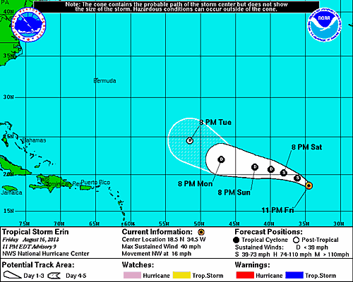
11 PM Update | Erin Strengthens to a Tropical Storm
Erin strengthens back to a tropical storm this evening and has changed course. TS Erin is now moving to the northwest at 16 mph with maximum sustained winds of 40 mph. The minimum central pressure has dropped to 1006 mb. Erin will be moving near a dry air mass that will weaken her again early Sunday morning.
The forecast continues to show Erin dissipating early in the week far away from land or any cruise destinations.
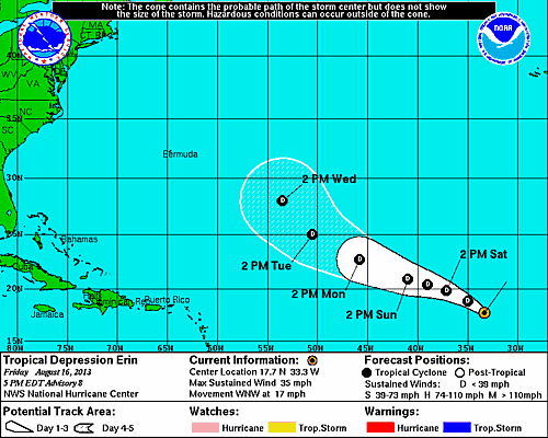
5 PM Update | Little Change
Tropical Depression Erin has not changed much this afternoon. Erin remain on a west-northwest heading at 17 mph with maximum sustained winds of 35 mph. Erin could degenerate into a remnant low or an open trough during the ned few days.
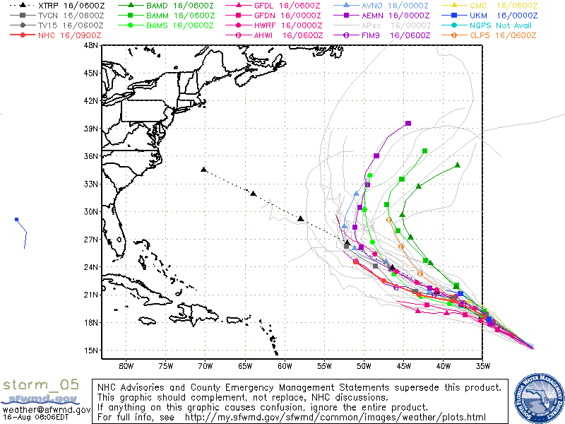
11 AM Update | Erin Weakens to a Tropical Depression
The National Hurricane Center just downgraded the weakening TS Erin to a Tropical Depression Erin much earlier than originally expected. The weakening has been attributed to the cooler sea surface temperatures and a stable air mass. Tropical Depression Erin is now moving west-northwest at 17 mph with max winds down to 35 mph. The minim central pressure has risen again to 1008 mb. Little change in strength is expected over the next couple days.
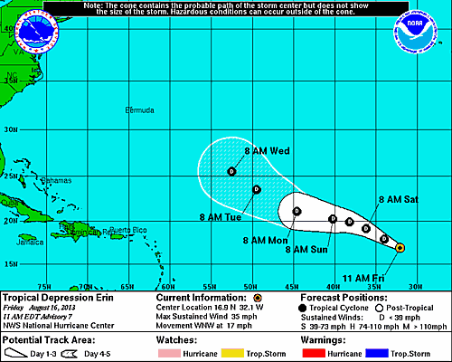
It is quite possible that TD Erin will further weaken to a remnant low or even an open trough during the next few days despite moving back over warmer water. By that time, she should be out of steam.
5 AM Update | Erin is a Little Disorganized
Tropical Storm Erin did not change much overnight. Erin is still moving to the west-northwest at 16 mph with maximum sustained winds of 40 mph and pressure is holding at 1007 mb. TS Erin will stay on this course through Saturday with some gradual slowing. Then, Erin will temporarily head west until she takes a turn to the north.
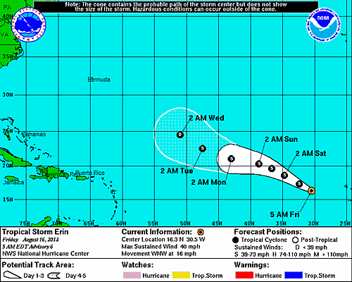
The latest model runs have all shifted Erin North. As a result, the NHC has shifted the official track to the North. The NHC track still resided to the south to the model consensus. As you can see below, the long range forecast for Tropical Storm Erin keeps her in the open waters of the Atlantic.
While TS Erin looks to be on the way out, another storm is about to emerge from the coast of Africa that will be worth keeping an eye on. Erin could very well be clearing out any atmospheric roadblocks ahead of this potential system.
Invest 92L | Gulf of Mexico
Elsewhere, we still have Invest 92L emerging off the Yucatan Peninsula into the Gulf of Mexico. The National Hurricane Center has it as a medium chance for development during the next couple days. Today’s Hurricane Hunter flight has been canceled.
System History
This table contains the NHC’s statistics for the tropical cyclone from each advisory.
| Date | Time (EST) | Classification | Max Winds (mph) | Movement/Speed | Pressure (mb) |
| Aug 14 | 11 PM | Tropical Depression | 35 | WNW at 14 mph | 1008 |
| Aug 15 | 5 AM | 35 | WNW at 16 mph | 1007 | |
| 8 AM* | Tropical Storm | 40 | WNW at 16 mph | 1006 | |
| 11 AM | 40 | WNW at 15 mph | 1006 | ||
| 5 PM | 40 | WNW at 14 mph | 1006 | ||
| 11 PM | 40 | WNW at 15 mph | 1007 |
||
| Aug 16 | 5 AM | 40 | WNW at 16 mph | 1007 | |
| 11 AM | Tropical Depression | 35 | WNW at 17 mph | 1008 | |
| 5 PM | 35 | WNW at 17 mph | 1008 | ||
| 11 PM | Tropical Storm | 40 | NW at 15 mph | 1006 |