
11 PM Update – Dorian on Life Support
Tropical Storm Dorian is on life support this evening and is expected to dissipate in the next day or so to a remnant low. Dorian is presently located about 985 miles east of the Northern Leeward Island with maximum sustained winds of 40 mph with an estimated central pressure of 1010 mb.
The NHC almost declared Dorian a remnant low tonight, but decided to hold off given the fact that the circulation is moving over warmer waters and the shear is expected to lessen giving the system one last hurrah. The decision was made to continue to monitor Dorian for a couple more advisory cycles (5AM & 11AM).
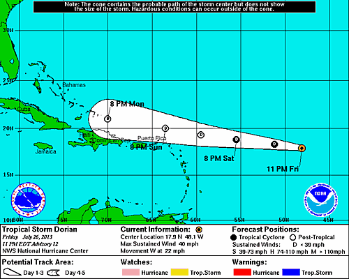
There is new tropical wave that has emerged off the coast of Africa that has about an ~7% chance of becoming a tropical cyclone in the next 48 hrs.
5 PM Update – Dorian Weakens
Tropical Storm Dorian continues to weaken and become disorganized as a result of westerly shear and a drier air mass. Dorian is now moving West at a brisk 22 mph with maximum sustained winds dropping to 45 mph. Although weakening, Dorian’s tropical storm force winds are now reaching outwards of 70 miles. Presently, Dorian is located 1135 miles east of the Northern Leeward Islands. The latest estimated central pressure has risen to 1010 mb (another sign of weakening).
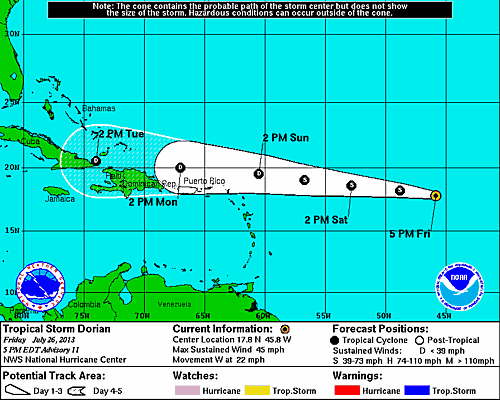
The forecast now shows TS Dorian slowing to a tropical depression on Sunday and completely disapating by day 5! However, the system could degenerate into a tropical wave sooner. The forecast track has shifted south from earlier today as a result of the high pressure system north of Dorian in the central Atlantic. This high is moving west and will continue to keep what is currently TS Dorian on a western track.
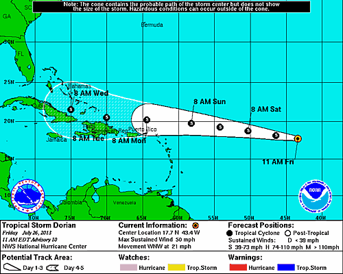
11 AM Update – Dorian Remains Disorganized
Tropical Storm Dorian remains disorganized based on visual satellite images and appears to be weakening a bit. Dorian’s west-northwest movement sped up to 21 mph with a considerable increase in the estimated minimum central pressure which has risen to 1006 mb. Maximum sustained winds are still around 50 mph with a reach of 60 miles. TS Dorian is expected to track to the west at a slightly faster forward speed over the next couple of days.
An area of dry air in conjunction with moderate west-southwesterly shear should cause some further weakening of the system. This is the second update in a row in which the NHC has suggested Tropical Storm Dorian could degenerate into a tropical wave sometime this weekend. As of this morning, the Hurricane Hunter are scheduled to begin their 6-hour fixes on TS Dorian on Sunday afternoon.
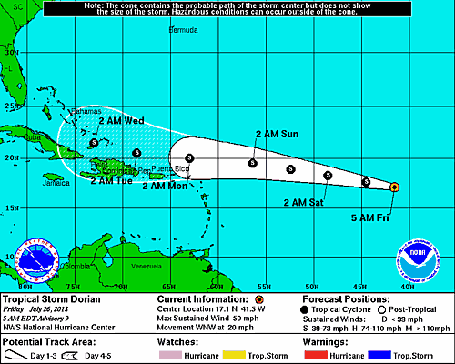
5 AM Update – Dorian Becomes Slightly Disorganized Overnight
Tropical Storm Dorian remains approximately 1425 miles east of the Northern Leeward Islands on a west-northwest course moving at 20 mph. Dorian’s winds continue to max out at 50 mph and are extending outward some 60 miles. A turn towards the west is expected over the next couple days in conjunction with an increase in forward speed. The latest satellite data shows Dorian becoming less organized due to the southwesterly shear mentioned during last night’s llPM update which may lead to continued weakening period today.
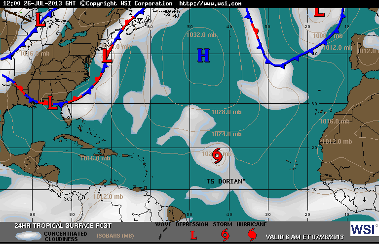
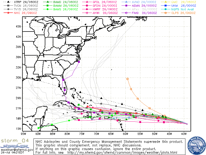
The high pressure system in the Central Atlantic continues to drive TS Dorian on a west-northwest track. You can see in the surface analysis below that Dorian is interacting with the high essentially being pushed to the west.
The forecast track from the National Hurricane Center remains in agreement with the models. There is an area of dry air directly to the west of Dorian that in will help weaken the system over the next day or so, but the forecast shows some re-intensificaiton in about 4 days. As of now, the intensity forecast shows winds topping out at 50 mph early next week.
Below is a look at the various models tracks which are mostly in agreement.
Based on what we know now, the NHC has proposed an alternative scenario where Tropical Storm Dorian could dissipate due to landfall in Hispaniola, or due to the the current hostile environment that is already weakening the system.
System History
| Date | Time | Classification | Max Winds (mph) | Movement/Speed | Pressure (mb) |
| July 24 | 5AM EST | Tropical Depression | 35 | WNW at 20 mph | 1008 |
| 11AM EST | Tropical Storm | 50 | WNW at 21 mph | 1002 | |
| 5PM EST | 50 | WNW at 20 mph | 1002 | ||
| 11PM EST | 50 | WNW at 20 mph | 1002 | ||
| July 25 | 5AM EST | Tropical Storm | 60 | WNW at 17 mph | 999 |
| 11AM EST | 60 | WNW at 17 mph | 999 | ||
| 5PM EST | 60 | WNW at 18 mph | 999 | ||
| 11PM EST | 50 | WNW at 20 mph | 1001 | ||
| July 26 | 5AM EST | Tropical Storm | 50 | WNW at 20 mph | 1001 |
| 11AM EST | 50 | WNW at 21 mph | 1006 | ||
| 5PM EST | 45 | W at 22 mph | 1010 | ||
| 11PM EST | 40 | W at 22 mph | 1010 |