
11 PM Update
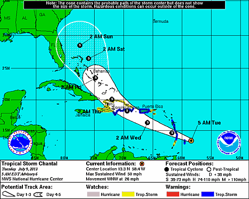
The center of Tropical Storm Chantal is passing about 215 miles south of Puerto Rico. Chantal has picked up about 2 mph and is currently moving at 28 mph, but her minimum central pressure has risen to 1009mb and maximum sustained winds have dropped to 60 mph. The latest updated suggests there will be little change in intensity between now and the time she makes landfall in Hispaniola. The forecast track shifted slightly to the west.
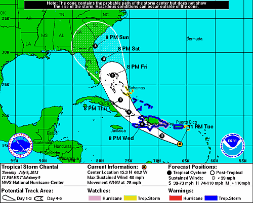
The rapid forward motion of Chantal could suggest that a westerly low to mid level shear is having an affect which could limit intensification between now an the time she makes landfall in Hispaniola. Once Chantal interacts with the topography of the land mass should disrupt the circulation causing significant weakening or best case dissipation. If Chantal survives the interaction with the land mass and strong westerly shear, the system could restrengthen as she makes her way into the Bahamian waters. The NHC notes that there is significant uncertainty in the intensity forecast 3 to 5 days from now.
This is the last update for 7/9/2013. There will be a new post Wednesday to document the tropical storm.
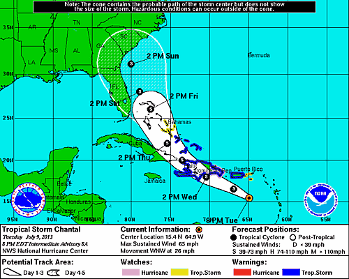
8 PM Update
Tropical Storm Chantal remains steady this evening continuing along the forecast track at 26 mph with maximum sustained winds of 65 mph. The estimated minimum central pressure remains at 1006mb.
5 PM Update
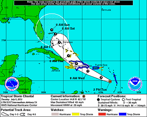
Tropical Storm Chantal is approximately 270 miles south east of San Juan, Puerto Rico over the open waters of the Eastern Caribbean on a West Northwest heading towards Hispaniola moving at a brisk at 26 mph. The estimated minimum central pressure remains at 1006mb. Maximum sustained winds are near 65 mph with higher gusts. This area of strong wind is located to east of the center of circulation. Tropical storm force winds continue to extend outward up to 90 miles. The Bahamian government has issued a tropical storm warning for the Turks and Caicos Islands as well as the Southeastern Bahamas. Haiti is now completely under a tropical storm warning.
Chantal is expected to intensify and be near hurricane strength by the time she makes landfall in the Dominican Republic on Wednesday afternoon.
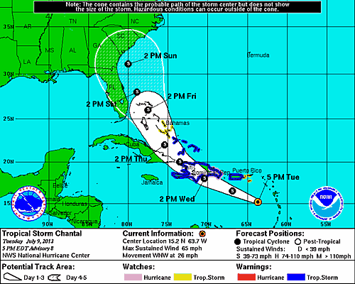
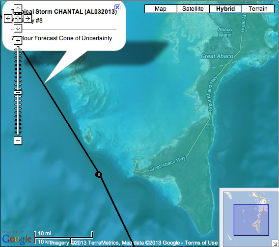
That latest forecast track saw a slight westward shift bringing her closer to Nassau on Thursday and positioning the center near Castaway Cay on Friday afternoon, a day in which the [Disney_Fantasy] is scheduled to be in port. For those not familiar with the area, Castaway Cay is the small island just to the east of the black forecast line.
2 PM Update
Tropical Storm Chantal continues to intensify this afternoon with maximum sustained winds of 65 mph. These winds were observed to a small area to the east of the center. Chantal is steaming away from the Lesser Antilles into the Eastern Caribbean Sea at 29 mph. A slight increase in strength is possible before Chantal reaches Hispaniola on Wednesday.
The long range forecast for the end of the week has Tropical Storm Chantal passing to to the East of both Nassau on Friday and Castaway Cay on Saturday.
11 AM Update
This morning the Hurricane Hunters flew into Tropical Storm Chantal collecting some valuable data. Chantal is now moving at 29 mph between Martinique and St Lucia with increased winds of 60 mph. The minimum central pressure has dropped to 1006mb (although recon did measure a low of 1003mb). As a result of this mornings intensification, the Dominican Republic has issued a hurricane watch from Barahona to Samana. Haiti has issued a tropical storm warning for it’s Northern coast.
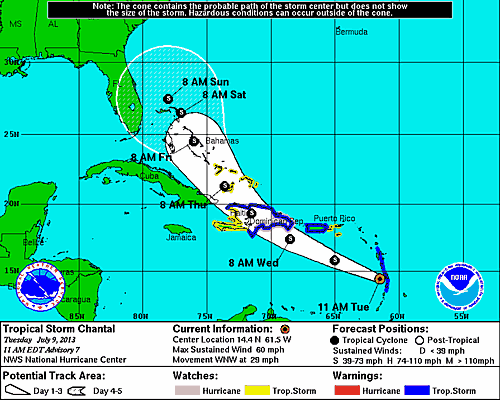
The long range forecast track continues to place the Bahamas in her path as a tropical storm with an indication of a slight turn to the west towards the Atlantic coast of Florida potentially affecting Port Canaveral. Additionally, it looks like Chantal’s forward movement will begin to slow down as she enters Bahamian waters.
As of this update, there have been no changes posted on Disney Cruise Line’s website. Since, I received a few inquiries this morning here is a link to Disney Cruise Line’s Cruise Contract. Finally, you can always call Port Canaveral at (321) 783-7831 and select option 4 to listen to the current status of the port as a result of tropical weather.
8 AM Update
Tropical Storm Chantal has been observed by the Barbados and Martinique radars. Chantal is currently approximately 45 miles east of Barbados and 85 miles east of St Lucia with winds holding at 50 mph. Chantal continues to move West Northwest at 26 mph with an estimated central pressure of 1010mb.
The Bahamian government has issued a tropical storm watch for the Turks and Caicos Islands as well as the Southeastern Bahamas. Tropical storm force winds continue to reach outward up to 90 miles, mostly north of the center of circulation. Strengthening is expected over the next 48 hours. The Hurricane Hunters are en-route to the get a fix on Chantal providing valuable data for the next forecast update.
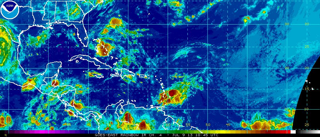
Elsewhere, an area of disorganized storms has formed off the coast of Africa that may we worth keeping an eye one for potential development. This is visible in the bottom right hand corner for the GOES-East satellite view below.
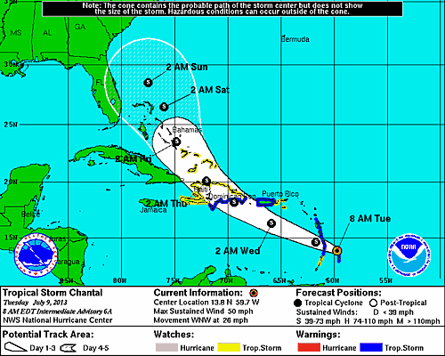
5 AM Update
Tropical Storm Chantal has changed very little overnight and continues to move westward through the Leeward and Windward Islands at 25 mph with maximum sustained winds of 50 mph. Outer wind bands of tropical storm strength are reaching outwards up to 90 miles. The estimated minimum central pressures is holding at 1010mb. A tropical storm watch has been issued for the northern coast of the Dominican Republic and Haiti.
The forecast track for Chantal again, has shifted a bit to the east and now projected to pass through the Bahamas on the Atlantic side further away from Nassau and Castaway Cay.
Although, weakening is expected when Chantal interacts with the rugged terrain of Hispaniola, the forecast suggests a restrengthening over open water and remain a tropical storm through the Bahamas. The Air Force Hurricane Hunters are scheduled to investigate Chantal later this morning providing a better assesment of the tropical storm.