
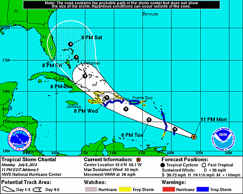
11PM Update
Tropical Storm Chantal is racing toward the Lesser Antilles West Northwest at 26 mph. The minimum central pressure was 1010 mb with maximum sustained winds of about 50 mph. The big news tonight is that Chantal will not be weakening following her landfall in Hispaniola and will now remain a tropical storm through the Bahamas. It is important to keep in mind that this forecast can change with regards to path and intensity as there are many factors in play. The potential impact Chantal could have on the Dream & Fantasy is not clear, nor will it for a few days. This is the last update for today. For continued coverage check the post Tropical Storm Chantal 7/9/2013.
8PM Update
This afternoon’s recon flight was able to determine that Tropical Storm Chantal a little stronger. Chantal is continuing to move at 26 mph along the forecast track with winds up to 50 mph. Previous estimates had her central pressure at 1005 mb, but the Hurricane Hunters measured Chantal at 1010 mb. Additionally, Chantal’s tropical storm force winds are reaching outward to 90 miles from her center, a good 30 mile more than estimated earlier in the day. Tropical Storm Chantal is expected to reach the Lesser Antilles early Tuesday morning before moving into to Eastern Caribbean Sea.
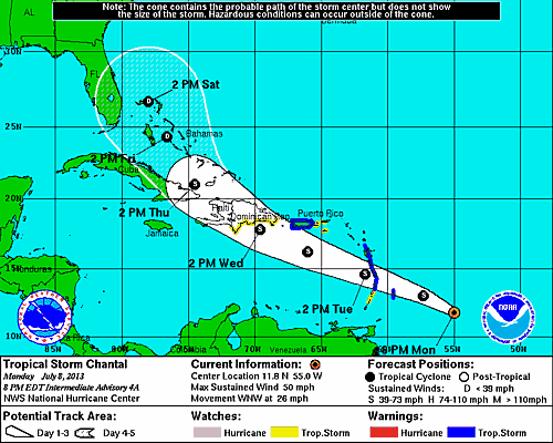
The latest NHC forecast track shows Chantal passing Nassau on Friday and skirting Castaway Cay on Saturday as a tropical depression, the same schedule as the Disney Dream.
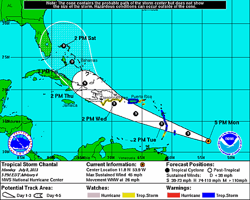
4PM Update
The Hurricane Hunters are nearing tropical storm Chantal which is now moving West Northwest at 26 mph with maximum sustained winds of 45 mph. The tropical storm force winds are extending outward up to 60 miles from the center, and the estimated pressure seems to be holding at 1005 mb. A tropical storm watch has been added for parts of the Dominican Republic as well as the US Virgin Islands. The next update should provide a much better picture of Chantal as the NHC will have some realtime data to work with that will soon be collected by the recon flight.
The forecast path has changed with a slight course change to the north as Chantal makes landfall in Hispaniola, whereas before the forecast indicated a turn near Cuba.
2PM Update
As previously mentioned, the Hurricane Hunter’s recon flight is now en-route to investigate Tropical Storm Chantal. Not much other than current position has changed over the last few hours. Chantal is presently positioned 470 East Southeast of Barbados moving West Northwest at 25 mph with maximum sustained winds of 45 mph.

Elsewhere, the National Hurricane Center has added an area of interest which is producing a large area of disturbed weather across the central and souther Bahamas this afternoon. The system currently has a 0% chance of becoming a tropical cyclone over the next 48 hours as it moves westward at 10-15 mph. The system at time will likely produce heavy rainfall and gusty winds across the Bahamas.
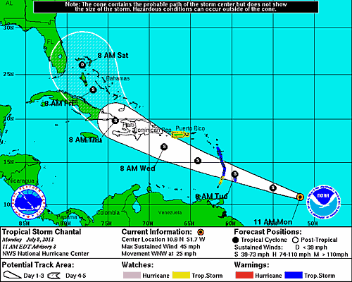
11AM Update
The late morning update on tropical storm Chantal has the system strengthening slightly on a West Northwest heading at 25 mph. Although, her forward speed dropped my 1 mph her maximum sustained winds have increased to 45 mph. A tropical storm warning has been issued for Puerto Rico. The forecast track remains mostly unchanged with a weakening later in the week as Chantal interacts with Hispaniola and the eastern tip of Cuba. The Hurricane Hunters have a mission planned for this afternoon to get a fix on the Chantal, providing realtime data that will be used to generate a more accurate forecast. (I also fixed my spelling error from Chantel to Chantal)
8AM Update
Late last night, the fast moving Invest 95L intensified into Tropical Storm Chantel. TS Chantal is currently moving quickly west towards the Lesser Antilles at 26 mph with maximum sustained winds of 40 mph. As of 8AM, Chantal was located approximately 630 miles East Southeast of Barbados. Tropical storm warnings are in effect for Barbados, Dominica, St Lucia, Martinique, and Guadeloupe with a tropical storm watch for St Vincent.
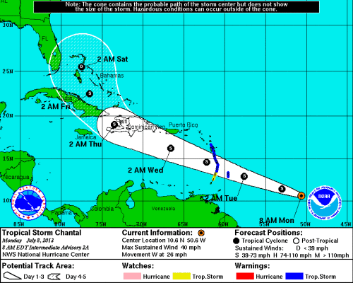
The current forecast has TS Chantal reaching the Lesser Antilles early Tuesday before moving into the Eastern Caribbean Sea later in the day. Tropical storm force winds may extend outward up to 60 miles. So far, the wind speed probability forecast does not show Chantal developing into a hurricane.
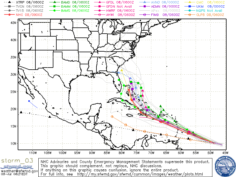
The majority of the models mapped by SFWMD are in agreement that the system will continue on it’s forecast path through Hispaniola before heading north northwest into the Bahamas. Cuba could play a significant role in the system if it crosses over the Sierra Maestra mountain range, which would disrupt the circulation and weakening the system before emerging into the Bahamas.
Upcoming Cruise Outlook
The [Disney_Fantasy] is sailing on a Western Caribbean cruise this week, but is scheduled to call on Castaway Cay on Friday ahead of the system. The [Disney_Dream] sails from Port Canaveral Thursday on a 3-Night cruise with Nassau on Friday, and Castaway Cay on Saturday.
If you are sailing this week, make sure to check Disney Cruise Line’s website for any Travel Advisories which will have a notice if there are any changes or modifications.
For the more information check out our Tropical Weather Center which is updated throughout the day with the latest information from the National Weather Service.